Pillow > Europe > France > Canton > Maine
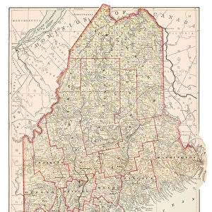
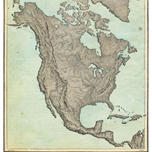
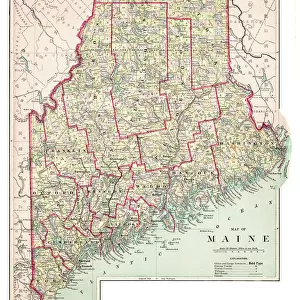
Pillow : Map of Maine USA 1883


![]()
Home Decor from Fine Art Storehouse
Map of Maine USA 1883
Warrens Common School Geography
Unleash your creativity and transform your space into a visual masterpiece!
THEPALMER
Media ID 13669351
© This content is subject to copyright
18"x18" (46x46cm) Pillow
18"x18" (46x46cm) Faux Suede Pillow with a plush soft feel. Your choice of image fills the front, with a stone colored faux suede back. Flat sewn concealed white zip.
Accessorise your space with decorative, soft pillows
Estimated Product Size is 45.7cm x 45.7cm (18" x 18")
These are individually made so all sizes are approximate
Artwork printed orientated as per the preview above, with landscape (horizontal) or portrait (vertical) orientation to match the source image.
FEATURES IN THESE COLLECTIONS
> Fine Art Storehouse
> The Magical World of Illustration
> Palmer Illustrated Collection
> Fine Art Storehouse
> Map
> Historical Maps
> Fine Art Storehouse
> Map
> USA Maps
> Europe
> France
> Canton
> Maine
> Maps and Charts
> Related Images
> North America
> Related Images
> North America
> United States of America
> Maine
> Related Images
> North America
> United States of America
> Maps
EDITORS COMMENTS
This print takes us back to the year 1883, showcasing a beautifully detailed "Map of Maine, USA". A true testament to the artistry and precision of cartography from that era, this engraving is a remarkable piece of history. The map's vertical orientation allows for an in-depth exploration of Maine's diverse landscapes and geographical features. The intricate lines etched onto paper reveal an antique charm that transports us to a time when maps were meticulously crafted by hand. Every contour, river, and mountain range has been carefully illustrated with utmost accuracy. It is evident that this map was created with great care and dedication. Maine itself emerges as the focal point within North America on this stunning representation. From its jagged coastline stretching along the Atlantic Ocean to its vast forests and picturesque lakes inland, every aspect of Maine's physical geography is captured in exquisite detail. As we delve into this vintage masterpiece by THEPALMER from Fine Art Storehouse, we are reminded of how far cartography has come since then. Yet it also serves as a reminder of the importance placed on understanding our surroundings through visual representations throughout history. Whether you are an enthusiast for historical artifacts or simply appreciate fine art prints that tell stories from times gone by, this Map of Maine USA 1883 will undoubtedly captivate your imagination and transport you back to an era where exploration was at its peak.
MADE IN THE USA
Safe Shipping with 30 Day Money Back Guarantee
FREE PERSONALISATION*
We are proud to offer a range of customisation features including Personalised Captions, Color Filters and Picture Zoom Tools
SECURE PAYMENTS
We happily accept a wide range of payment options so you can pay for the things you need in the way that is most convenient for you
* Options may vary by product and licensing agreement. Zoomed Pictures can be adjusted in the Cart.