Pillow > Europe > Iceland > Maps
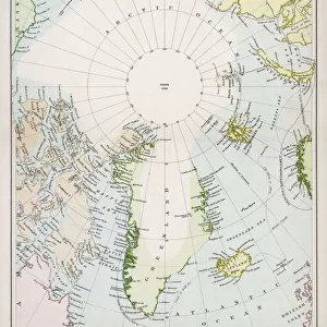
Pillow : Map of Denmark, Iceland, Faroe Islands and Schleswig-Holstein. lithograph, 1893


![]()
Home Decor from Fine Art Storehouse
Map of Denmark, Iceland, Faroe Islands and Schleswig-Holstein. lithograph, 1893
Historical map of Denmark with Iceland, the Faroe Islands and the Prussian province of Schleswig-Holstein. Lithograph, published in 1893
Unleash your creativity and transform your space into a visual masterpiece!
ZU_09
Media ID 35842588
18"x18" (46x46cm) Pillow
18"x18" (46x46cm) Faux Suede Pillow with a plush soft feel. Your choice of image fills the front, with a stone colored faux suede back. Flat sewn concealed white zip.
Accessorise your space with decorative, soft pillows
Estimated Product Size is 45.7cm x 45.7cm (18" x 18")
These are individually made so all sizes are approximate
Artwork printed orientated as per the preview above, with landscape (horizontal) or portrait (vertical) orientation to match the source image.
FEATURES IN THESE COLLECTIONS
> Fine Art Storehouse
> Map
> Historical Maps
> Europe
> Denmark
> Related Images
> Europe
> Iceland
> Related Images
> Maps and Charts
> Early Maps
> Maps and Charts
> Related Images
EDITORS COMMENTS
This stunning lithograph, published in 1893, presents a historical map of Denmark, Iceland, the Faroe Islands, and the Prussian province of Schleswig-Holstein. The intricate details of the map reveal the political boundaries and geographical features of the region during that time. Denmark, located in northern Europe, is depicted in the center of the map, with its peninsulas Jutland and Zealand clearly visible. To the north, the autonomous territories of the Faroe Islands and Iceland are shown, separated by the North Atlantic Ocean. The Faroe Islands, a cluster of eighteen islands, are depicted with their rugged coastlines and mountainous interiors. Iceland, the world's twentieth largest island, is shown with its volcanic landscape and glacial features. To the south of Denmark, the Prussian province of Schleswig-Holstein is depicted. This region, which was under Danish rule until the late 19th century, is shown with its intricate network of rivers and lakes, as well as its coastal areas. The map also includes various labels indicating important cities, towns, and natural features. This historical map provides a fascinating glimpse into the political and geographical landscape of northern Europe during the late 19th century. The intricate details and beautiful design make it a valuable addition to any collection of historical maps or art. Whether you are a historian, a collector, or simply someone with an interest in the history of Europe, this map is sure to captivate and inform.
MADE IN THE USA
Safe Shipping with 30 Day Money Back Guarantee
FREE PERSONALISATION*
We are proud to offer a range of customisation features including Personalised Captions, Color Filters and Picture Zoom Tools
SECURE PAYMENTS
We happily accept a wide range of payment options so you can pay for the things you need in the way that is most convenient for you
* Options may vary by product and licensing agreement. Zoomed Pictures can be adjusted in the Cart.