Pillow > Arts > Artists > M > Mexican School Mexican School
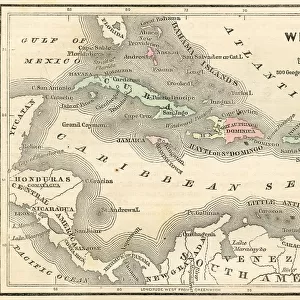
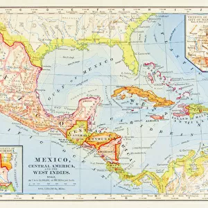
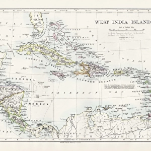
Pillow : Map of Mexico and West Indies 1895


![]()
Home Decor from Fine Art Storehouse
Map of Mexico and West Indies 1895
The Rand-McNally Grammar School Geography 1895 - Chicago & New York
Unleash your creativity and transform your space into a visual masterpiece!
THEPALMER
Media ID 14824637
© This content is subject to copyright
Caribbean Central America Cuba Dominican Republic Honduras Mexico Nicaragua Panama Puerto Rico West Indies
18"x18" (46x46cm) Pillow
18"x18" (46x46cm) Faux Suede Pillow with a plush soft feel. Your choice of image fills the front, with a stone colored faux suede back. Flat sewn concealed white zip.
Accessorise your space with decorative, soft pillows
Estimated Product Size is 45.7cm x 45.7cm (18" x 18")
These are individually made so all sizes are approximate
Artwork printed orientated as per the preview above, with landscape (horizontal) or portrait (vertical) orientation to match the source image.
FEATURES IN THESE COLLECTIONS
> Fine Art Storehouse
> Map
> Historical Maps
> Arts
> Artists
> M
> Mexican School Mexican School
> Maps and Charts
> Related Images
> North America
> Cuba
> Maps
> North America
> Cuba
> Related Images
> North America
> Dominican Republic
> Maps
> North America
> Dominican Republic
> Related Images
> North America
> Honduras
> Maps
> North America
> Honduras
> Related Images
> North America
> Mexico
> Related Images
EDITORS COMMENTS
In this print titled "Map of Mexico and West Indies 1895" we are transported back in time to the late 19th century, when cartography was a meticulous art form. The map, sourced from "The Rand-McNally Grammar School Geography 1895" publication, showcases the rich tapestry of lands that make up the Caribbean and Central America. With its intricate details and vibrant colors, this piece offers a window into an era where exploration and discovery were at their peak. From Cuba to Puerto Rico, from Honduras to Panama, each country is meticulously outlined with precision and care. It serves as a testament to the importance of geography education during that period. As we delve deeper into this historical treasure trove, our eyes are drawn to the fine craftsmanship displayed by THEPALMER in preserving this relic. The attention paid to every minute detail allows us to appreciate not only the geographical features but also the cultural diversity present within these regions. This print invites us on a journey through time; it sparks curiosity about how these landscapes have evolved over more than a century. Whether you're an avid traveler or simply fascinated by history, "Map of Mexico and West Indies 1895" will undoubtedly captivate your imagination while adding a touch of vintage charm to any space it graces.
MADE IN THE USA
Safe Shipping with 30 Day Money Back Guarantee
FREE PERSONALISATION*
We are proud to offer a range of customisation features including Personalised Captions, Color Filters and Picture Zoom Tools
SECURE PAYMENTS
We happily accept a wide range of payment options so you can pay for the things you need in the way that is most convenient for you
* Options may vary by product and licensing agreement. Zoomed Pictures can be adjusted in the Cart.