Pillow > Europe > Germany > Maps
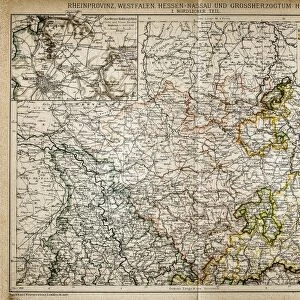
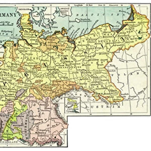
Pillow : Map of Rhine Province (Prussia, Germany), lithograph, published in 1897
, lithograph, published in 1897")
, lithograph, published in 1897")

![]()
Home Decor from Fine Art Storehouse
Map of Rhine Province (Prussia, Germany), lithograph, published in 1897
Topographic map of Rhine Province, the westernmost province of Prussia, within the German Reich, from 1822 to 1946. Lithograph, published in 1897
Unleash your creativity and transform your space into a visual masterpiece!
ZU_09
Media ID 18292253
18"x18" (46x46cm) Pillow
18"x18" (46x46cm) Faux Suede Pillow with a plush soft feel. Your choice of image fills the front, with a stone colored faux suede back. Flat sewn concealed white zip.
Accessorise your space with decorative, soft pillows
Estimated Product Size is 45.7cm x 45.7cm (18" x 18")
These are individually made so all sizes are approximate
Artwork printed orientated as per the preview above, with landscape (horizontal) or portrait (vertical) orientation to match the source image.
FEATURES IN THESE COLLECTIONS
> Fine Art Storehouse
> Map
> Historical Maps
> Maps and Charts
> Related Images
EDITORS COMMENTS
This lithograph, titled "Map of Rhine Province (Prussia, Germany)" takes us on a visual journey back to the late 19th century. Published in 1897, it offers a detailed topographic representation of the westernmost province of Prussia within the German Reich. The artist behind this remarkable piece is ZU_09. The map showcases the intricate network of rivers and tributaries that crisscross through this historically significant region. From its source in Switzerland's Alps to its mouth at the North Sea, the mighty Rhine River dominates the landscape depicted here. Its meandering path is surrounded by lush green valleys, picturesque towns, and imposing castles perched atop hillsides. As we explore further into this lithograph, we discover an abundance of information meticulously etched onto its surface. Towns and cities are marked with tiny dots or names written in elegant calligraphy. Forested areas are represented by delicate lines mimicking nature's patterns. Beyond being aesthetically pleasing, this map serves as a valuable historical artifact. It provides insight into how borders were defined during a time when Prussia played a central role in shaping Germany's political landscape. Whether you're an avid cartography enthusiast or simply intrigued by history, this print transports you to another era while offering glimpses into both natural beauty and geopolitical intricacies. A true testament to ZU_09's skillful craftsmanship and attention to detail!
MADE IN THE USA
Safe Shipping with 30 Day Money Back Guarantee
FREE PERSONALISATION*
We are proud to offer a range of customisation features including Personalised Captions, Color Filters and Picture Zoom Tools
SECURE PAYMENTS
We happily accept a wide range of payment options so you can pay for the things you need in the way that is most convenient for you
* Options may vary by product and licensing agreement. Zoomed Pictures can be adjusted in the Cart.