Pillow > Europe > United Kingdom > England > Essex > Canvey Island
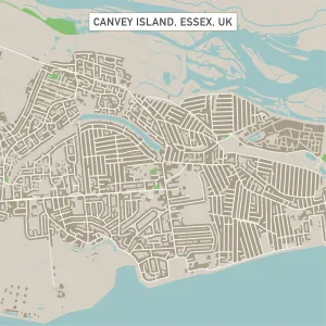
Pillow : Canvey Island Essex UK City Street Map


![]()
Home Decor from Fine Art Storehouse
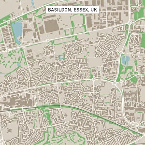
Canvey Island Essex UK City Street Map
Vector Illustration of a City Street Map of Canvey Island, Essex, UK. Included files are EPS (v10) and Hi-Res JPG.
Data courtesy from Ordnance Survey: VectorMap District
https:/ordnancesurvey.co.uk/business-and-government/products/vectormap-district.html
OS OpenData is free to use under the Open Government Licence (OGL).
Contains OS data eCrown copyright and database right 2017.
http:/nationalarchives.gov.uk/doc/open-government-licence/version/3/
Unleash your creativity and transform your space into a visual masterpiece!
Frank Ramspott
Media ID 15055223
© Frank Ramspott, all rights reserved
Aerial View Computer Graphic Directly Above Essex Gray Green North Sea Road Map Street Map Text Thames Canvey Island Digitally Generated Image Thames Estuary
18"x18" (46x46cm) Pillow
18"x18" (46x46cm) Faux Suede Pillow with a plush soft feel. Your choice of image fills the front, with a stone colored faux suede back. Flat sewn concealed white zip.
Accessorise your space with decorative, soft pillows
Estimated Product Size is 45.7cm x 45.7cm (18" x 18")
These are individually made so all sizes are approximate
Artwork printed orientated as per the preview above, with landscape (horizontal) or portrait (vertical) orientation to match the source image.
FEATURES IN THESE COLLECTIONS
> Fine Art Storehouse
> Map
> Street Maps
> Aerial Photography
> Related Images
> Arts
> Contemporary art
> Digital artwork
> Street art
> Arts
> Portraits
> Pop art gallery
> Street art portraits
> Arts
> Street art graffiti
> Digital art
> Digital paintings
> Arts
> Street art graffiti
> Digital art
> Vector illustrations
> Europe
> United Kingdom
> England
> Essex
> Canvey Island
> Europe
> United Kingdom
> England
> Essex
> Grays
> Europe
> United Kingdom
> England
> Essex
> Related Images
> Europe
> United Kingdom
> Maps
> Maps and Charts
> Related Images
EDITORS COMMENTS
This print showcases a meticulously detailed vector illustration of the charming Canvey Island in Essex, UK. The city street map is expertly crafted, highlighting every road and building with precision. The inclusion of EPS (v10) and Hi-Res JPG files ensures optimal quality for any purpose. The data used to create this masterpiece is courtesy of Ordnance Survey's VectorMap District, a reliable source known for its accuracy. It is worth noting that OS OpenData allows free usage under the Open Government Licence (OGL), emphasizing transparency and accessibility. From the aerial perspective captured in this digitally generated image, one can appreciate the beauty of Canvey Island nestled between the Thames Estuary and North Sea. The color palette consists of shades of gray, green, blue, and white, enhancing both clarity and aesthetics. This stunning piece combines elements of cartography with modern design techniques to produce an artwork that appeals to both enthusiasts and professionals alike. With no people present in the image itself, it focuses solely on showcasing the physical geography and layout of Canvey Island. Frank Ramspott's skillful execution brings life to this city street map print from Fine Art Storehouse. Whether you are seeking inspiration or simply admire intricate computer graphics depicting real-world locations, this artwork will undoubtedly captivate your imagination.
MADE IN THE USA
Safe Shipping with 30 Day Money Back Guarantee
FREE PERSONALISATION*
We are proud to offer a range of customisation features including Personalised Captions, Color Filters and Picture Zoom Tools
SECURE PAYMENTS
We happily accept a wide range of payment options so you can pay for the things you need in the way that is most convenient for you
* Options may vary by product and licensing agreement. Zoomed Pictures can be adjusted in the Cart.