Pillow > Europe > United Kingdom > Scotland > Edinburgh > Edinburgh
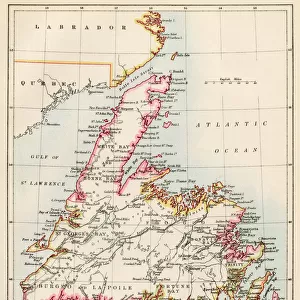
Pillow : Map of North America, 1902. Creator: Unknown


![]()
Home Decor from Heritage Images
Map of North America, 1902. Creator: Unknown
Map of North America, 1902. Showing the USA, Canada, Greenland, Central America and the Caribbean, with an inset of the Isthmus of Nicaragua. From The Century Atlas of the World. [John Walker & Co, Ltd. London, 1902]
Heritage Images features heritage image collections
Media ID 15515524
© The Print Collector / Heritage-Images
Canada Caribbean Central America Coastline Edinburgh Geographical Institute Greenland Isthmus North America North And Central America
18"x18" (46x46cm) Pillow
18"x18" (46x46cm) Faux Suede Pillow with a plush soft feel. Your choice of image fills the front, with a stone colored faux suede back. Flat sewn concealed white zip.
Accessorise your space with decorative, soft pillows
Estimated Product Size is 45.7cm x 45.7cm (18" x 18")
These are individually made so all sizes are approximate
Artwork printed orientated as per the preview above, with landscape (horizontal) or portrait (vertical) orientation to match the source image.
FEATURES IN THESE COLLECTIONS
> Europe
> United Kingdom
> Scotland
> Edinburgh
> Edinburgh
> Europe
> United Kingdom
> Scotland
> Lothian
> Edinburgh
> Maps and Charts
> Related Images
> Maps and Charts
> World
> North America
> Canada
> Maps
> North America
> Canada
> Related Images
> North America
> Greenland
> Maps
> North America
> Greenland
> Related Images
> North America
> Nicaragua
> Maps
EDITORS COMMENTS
This print showcases a beautifully detailed "Map of North America, 1902". The creator remains unknown, but their expertise in cartography is evident. The map encompasses the vast expanse of North America, featuring the United States, Canada, Greenland, Central America, and the Caribbean. The intricate details highlight various geographical features such as coastlines and seas. A special inset focuses on the Isthmus of Nicaragua—a narrow strip connecting two larger land masses—providing additional insight into this significant location. Printed in color by John Walker & Co. , Ltd. in London during the early 20th century (1900s), this map emanates historical charm. Its vibrant hues bring life to each country and region depicted. Crafted by the Edinburgh Geographical Institute, this map serves as a testament to their dedication to accuracy and precision in representing our world's geography. It offers an invaluable resource for scholars and enthusiasts alike seeking knowledge about North American countries' locations and boundaries during that period. Preserved by The Print Collector—an organization dedicated to safeguarding historical prints—this particular piece has been carefully maintained over time. While its original purpose may have been educational or informative, today it stands as a remarkable work of art that allows us to appreciate both its aesthetic appeal and historical significance.
MADE IN THE USA
Safe Shipping with 30 Day Money Back Guarantee
FREE PERSONALISATION*
We are proud to offer a range of customisation features including Personalised Captions, Color Filters and Picture Zoom Tools
SECURE PAYMENTS
We happily accept a wide range of payment options so you can pay for the things you need in the way that is most convenient for you
* Options may vary by product and licensing agreement. Zoomed Pictures can be adjusted in the Cart.