Pillow > Arts > Artists > O > Oceanic Oceanic
Pillow : GPAC2A-00018


![]()
Home Decor from North Wind
GPAC2A-00018
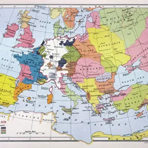
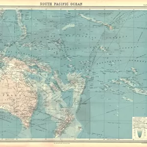
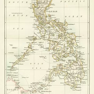
Map of the Pacific island groups, 1800s.
Hand-colored woodcut of a 19th-century illustration
North Wind Picture Archives brings history to life with stock images and hand-colored illustrations
Media ID 5882605
© North Wind Picture Archives
Asia Asian Australia Indonesia Island Java Ocean Oceania Pacific Pacific Ocean Philippines Polynesia Borneo Micronesia New Guinea Pacific Islands Philippine Islands South China Sea
18"x18" (46x46cm) Pillow
18"x18" (46x46cm) Faux Suede Pillow with a plush soft feel. Your choice of image fills the front, with a stone colored faux suede back. Flat sewn concealed white zip.
Accessorise your space with decorative, soft pillows
Estimated Product Size is 45.7cm x 45.7cm (18" x 18")
These are individually made so all sizes are approximate
Artwork printed orientated as per the preview above, with landscape (horizontal) or portrait (vertical) orientation to match the source image.
FEATURES IN THESE COLLECTIONS
> North Wind Picture Archives
> Maps
> Animals
> Fishes
> G
> Grouper
> Arts
> Artists
> O
> Oceanic Oceanic
> Asia
> Indonesia
> Related Images
> Asia
> Malaysia
> Related Images
> Asia
> Philippines
> Maps
EDITORS COMMENTS
This print showcases a hand-colored woodcut of a 19th-century illustration, titled "GPAC2A-00018: Map of the Pacific island groups". Steeped in history and cultural significance, this vintage artwork takes us on a journey through the vast expanse of the Pacific Ocean. The intricate details of this map highlight various island groups that dot the ocean's surface. From Australia to Malaysia, from Indonesia to New Zealand, it encompasses an extensive range of territories. The artist skillfully captures the essence of each region with traditional motifs and symbols unique to their respective cultures. As we explore this visual masterpiece, we are transported back in time to an era when these islands were still largely unexplored by Western civilization. It serves as a testament to the curiosity and adventurous spirit that drove explorers across treacherous seas in search of new lands. The map not only provides geographical information but also offers glimpses into the historical context surrounding these regions. It sheds light on ancient trade routes, colonial influences, and indigenous communities that have thrived for centuries amidst breathtaking natural landscapes. With its vibrant colors and meticulous craftsmanship, this artful representation invites us to appreciate both the beauty and complexity of Oceania's diverse tapestry. Whether you are an art enthusiast or a history buff, this piece is sure to ignite your imagination as you embark on a visual voyage through time and space.
MADE IN THE USA
Safe Shipping with 30 Day Money Back Guarantee
FREE PERSONALISATION*
We are proud to offer a range of customisation features including Personalised Captions, Color Filters and Picture Zoom Tools
SECURE PAYMENTS
We happily accept a wide range of payment options so you can pay for the things you need in the way that is most convenient for you
* Options may vary by product and licensing agreement. Zoomed Pictures can be adjusted in the Cart.