Pillow > Europe > United Kingdom > England > Sussex > East Marden
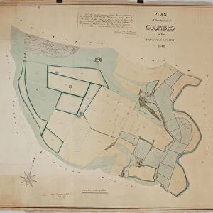
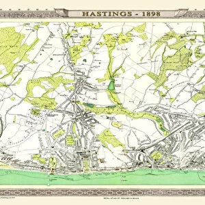
Pillow : East Marden tithe map, 1842


![]()
Home Decor from West Sussex County Council
East Marden tithe map, 1842
By Edward Fuller, Surveyor, Chichester. 20 in. to 1 m. 56 × 39
Tithe Award Map Collection
West Sussex Record Office Ref No: TD/W49
West Sussex County Council Record Office contains a fascinating history of the county of West Sussex, England
Media ID 10716295
© West Sussex County Council - All Rights Reserved
1840s 19th Century Historical Mapping South Of England
18"x18" (46x46cm) Pillow
18"x18" (46x46cm) Faux Suede Pillow with a plush soft feel. Your choice of image fills the front, with a stone colored faux suede back. Flat sewn concealed white zip.
Accessorise your space with decorative, soft pillows
Estimated Product Size is 45.7cm x 45.7cm (18" x 18")
These are individually made so all sizes are approximate
Artwork printed orientated as per the preview above, with landscape (horizontal) or portrait (vertical) orientation to match the source image.
FEATURES IN THESE COLLECTIONS
> Europe
> United Kingdom
> England
> Chichester
> Europe
> United Kingdom
> England
> East Sussex
> Related Images
> Europe
> United Kingdom
> England
> Maps
> Europe
> United Kingdom
> England
> Sussex
> Chichester
> Europe
> United Kingdom
> England
> Sussex
> East Marden
> Europe
> United Kingdom
> England
> Sussex
> Related Images
> Europe
> United Kingdom
> England
> Sussex
> West Marden
> Europe
> United Kingdom
> England
> West Sussex
> Chichester
> Europe
> United Kingdom
> England
> West Sussex
> Related Images
> Maps and Charts
> Early Maps
EDITORS COMMENTS
This print showcases the East Marden tithe map from 1842, a remarkable piece of historical mapping that offers a glimpse into the past. Created by Edward Fuller, an esteemed surveyor from Chichester, this meticulously detailed map provides valuable insights into the land and its use during the 19th century in southern England. Measuring an impressive 20 inches to one mile, this stunning reproduction captures every intricate detail with utmost precision. The East Marden tithe map is part of the renowned Tithe Award Map Collection housed at West Sussex Record Office. With reference number TD/W49, it stands as a testament to our rich cultural heritage and serves as an invaluable resource for researchers and history enthusiasts alike. Transporting us back in time, this photograph allows us to explore the landscape as it once was - revealing fields, farms, roads, and boundaries that have shaped East Marden's history. It offers a unique opportunity to delve into rural life during this era and gain insight into how land was utilized for agricultural purposes. While not intended for commercial use or promotion of any company or product, this print invites us on a journey through time. It reminds us of our responsibility to preserve these historical treasures so future generations can continue to learn from them.
MADE IN THE USA
Safe Shipping with 30 Day Money Back Guarantee
FREE PERSONALISATION*
We are proud to offer a range of customisation features including Personalised Captions, Color Filters and Picture Zoom Tools
SECURE PAYMENTS
We happily accept a wide range of payment options so you can pay for the things you need in the way that is most convenient for you
* Options may vary by product and licensing agreement. Zoomed Pictures can be adjusted in the Cart.