Poster Print > Europe > Italy > Maps
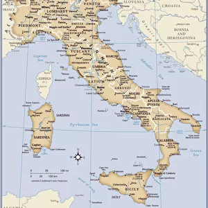
Poster Print : Map of Ancient Sicily and southern Italy, c. 278 BC. From Cassells Illustrated Universal History, published 1883
![]()

Poster Prints From Design Pics
Map of Ancient Sicily and southern Italy, c. 278 BC. From Cassells Illustrated Universal History, published 1883
Map of Ancient Sicily and southern Italy, c.278 BC. From Cassells Illustrated Universal History, published 1883
Design Pics offers Distinctively Different Imagery representing over 1,500 contributors
Media ID 24908371
© Ken Welsh
Ancient Civilizations Cartography Geographical Geography Italian Italy Southern
18x24 inch Poster Print
Step back in time with our exquisite Ancient Sicily and Southern Italy Poster Print by Ken Welsh from Design Pics. This captivating map, taken from the Cassells Illustrated Universal History published in 1883, offers a glimpse into the rich history of the ancient world. Explore the intricacies of the geography of Sicily and Italy around 278 BC, and adorn your walls with a piece of history that is sure to ignite curiosity and inspire conversation. Perfect for history enthusiasts and those seeking to add a touch of antiquity to their decor. Add this stunning poster print to your collection today!
Poster prints are budget friendly enlarged prints in standard poster paper sizes. Printed on 150 gsm Matte Paper for a natural feel and supplied rolled in a tube. Great for framing and should last many years. To clean wipe with a microfiber, non-abrasive cloth or napkin. Our Archival Quality Photo Prints and Fine Art Paper Prints are printed on higher quality paper and the choice of which largely depends on your budget.
Poster prints are budget friendly enlarged prints in standard poster paper sizes (A0, A1, A2, A3 etc). Whilst poster paper is sometimes thinner and less durable than our other paper types, they are still ok for framing and should last many years. Our Archival Quality Photo Prints and Fine Art Paper Prints are printed on higher quality paper and the choice of which largely depends on your budget.
Estimated Product Size is 61.6cm x 46.3cm (24.3" x 18.2")
These are individually made so all sizes are approximate
Artwork printed orientated as per the preview above, with landscape (horizontal) orientation to match the source image.
FEATURES IN THESE COLLECTIONS
> Europe
> Italy
> Sicily
> Related Images
> Historic
> Ancient civilizations
> Maps and Charts
> Early Maps
> Maps and Charts
> Italy
EDITORS COMMENTS
This print showcases a remarkable piece of history - the "Map of Ancient Sicily and southern Italy, c. 278 BC". Published in 1883 as part of Cassells Illustrated Universal History, this map offers a glimpse into the geographical landscape and ancient civilizations that once thrived in this region. The intricate details captured in this engraving highlight the rich cartography skills employed during that era. The boundaries of ancient Sicily and southern Italy are clearly demarcated, allowing viewers to trace the contours of these lands as they were over two thousand years ago. As we delve into this archival gem, we are transported back in time to an age where Italian culture flourished amidst magnificent landscapes. This picture is not just an illustration; it is a portal to explore the roots and origins of one of Europe's most influential countries. With its vintage charm and historical significance, this print by Ken Welsh serves as a valuable resource for historians, geographers, or anyone with an interest in ancient civilizations. It invites us to reflect upon how our world has evolved over centuries while reminding us that beneath modernity lies a tapestry woven with stories from antiquity. Whether displayed on your wall or used for educational purposes, let this image transport you back to 278 BC when Sicily and southern Italy were at their zenith – vibrant hubs teeming with life and cultural exchange.
MADE IN THE USA
Safe Shipping with 30 Day Money Back Guarantee
FREE PERSONALISATION*
We are proud to offer a range of customisation features including Personalised Captions, Color Filters and Picture Zoom Tools
SECURE PAYMENTS
We happily accept a wide range of payment options so you can pay for the things you need in the way that is most convenient for you
* Options may vary by product and licensing agreement. Zoomed Pictures can be adjusted in the Basket.


