Poster Print > Arts > Artists > S > Syrian Syrian
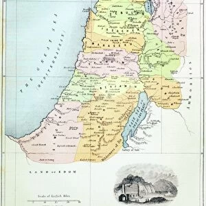
Poster Print : Map of Syria and Palestine in 624 AD during the invasion of Muhammad Arabs (570-632) (Historical map of middle east, Syria and Palestine during the conquest of Muslim arabs)
 (Historical map of middle east, Syria and Palestine during the conquest of Muslim arabs)")


![]()
Poster Prints from Fine Art Finder
Map of Syria and Palestine in 624 AD during the invasion of Muhammad Arabs (570-632) (Historical map of middle east, Syria and Palestine during the conquest of Muslim arabs)
ELD4921416 Map of Syria and Palestine in 624 AD during the invasion of Muhammad Arabs (570-632) (Historical map of middle east, Syria and Palestine during the conquest of Muslim arabs, 624 (634) AD ca) Engraving from Houze's " Atlas Universale" 1851 Private collection; (add.info.: Map of Syria and Palestine in 624 AD during the invasion of Muhammad Arabs (570-632) (Historical map of middle east, Syria and Palestine during the conquest of Muslim arabs, 624 (634) AD ca) Engraving from Houze's " Atlas Universale" 1851 Private collection); Photo © The Holbarn Archive
Media ID 38331220
© © The Holbarn Archive / Bridgeman Images
Islamic Religion Islamism Israel Israeli Muhammad Palestine Palestinian Syria Geographical Map Isadora
18x24 inch Poster Print
"Step back in time to 624 AD with our stunning poster print from Bridgeman Images, featuring a historical map of Syria and Palestine during the invasion of Muhammad's Arabs. This beautifully rendered illustration showcases the Middle East at a pivotal moment in history, as the Muslim armies spread across the region. Perfect for history buffs, art lovers, and anyone fascinated by ancient civilizations, this captivating print is sure to make a statement in any room.
Poster prints are budget friendly enlarged prints in standard poster paper sizes. Printed on 150 gsm Matte Paper for a natural feel and supplied rolled in a tube. Great for framing and should last many years. To clean wipe with a microfiber, non-abrasive cloth or napkin. Our Archival Quality Photo Prints and Fine Art Paper Prints are printed on higher quality paper and the choice of which largely depends on your budget.
Poster prints are budget friendly enlarged prints in standard poster paper sizes (A0, A1, A2, A3 etc). Whilst poster paper is sometimes thinner and less durable than our other paper types, they are still ok for framing and should last many years. Our Archival Quality Photo Prints and Fine Art Paper Prints are printed on higher quality paper and the choice of which largely depends on your budget.
Estimated Product Size is 46.3cm x 61.6cm (18.2" x 24.3")
These are individually made so all sizes are approximate
Artwork printed orientated as per the preview above, with portrait (vertical) orientation to match the source image.
FEATURES IN THESE COLLECTIONS
> Fine Art Finder
> Artists
> Emile Andre Schefer
> Arts
> Artists
> S
> Syrian Syrian
> Asia
> Israel
> Related Images
> Asia
> Palestine
> Related Images
> Asia
> Syria
> Related Images
> Maps and Charts
> Early Maps
EDITORS COMMENTS
This print showcases a historical map of Syria and Palestine in 624 AD during the invasion of Muhammad Arabs. The intricate details on this engraving from Houze's "Atlas Universale" in 1851 provide a glimpse into the geographical landscape and political boundaries of the Middle East during this significant period.
As we study this map, we can visualize the conquest of Muslim Arabs led by Prophet Muhammad (570-632) as they expanded their influence across the region. The strategic placement of cities, rivers, and mountains on the map offers valuable insights into how these territories were navigated and controlled during that time.
The rich history depicted in this image serves as a reminder of the complex interactions between different cultures and religions in Syria and Palestine centuries ago. It highlights the impact of Islamism on shaping the landscape and society of these regions, while also shedding light on the ongoing conflicts surrounding Israel and Palestinian territories.
Overall, this print is not just a visual representation but also a gateway to understanding the historical significance of events that unfolded in 624 AD. It invites us to reflect on how past invasions have shaped modern-day geopolitics in the Middle East.
MADE IN THE USA
Safe Shipping with 30 Day Money Back Guarantee
FREE PERSONALISATION*
We are proud to offer a range of customisation features including Personalised Captions, Color Filters and Picture Zoom Tools
SECURE PAYMENTS
We happily accept a wide range of payment options so you can pay for the things you need in the way that is most convenient for you
* Options may vary by product and licensing agreement. Zoomed Pictures can be adjusted in the Cart.