Poster Print > Africa > Tunisia > Maps
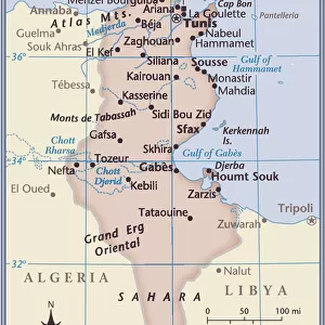
Poster Print : Universal Geography: Tunisia, under the Protectorate of France, beg of 20th century (lithograph)
")


![]()
Poster Prints from Fine Art Finder
Universal Geography: Tunisia, under the Protectorate of France, beg of 20th century (lithograph)
DUV4218001 Universal Geography: Tunisia, under the Protectorate of France, beg of 20th century (lithograph); 9.5x6.5 cm; (add.info.: Advertising images edited for the brand Louit); Photo © Duvallon
Media ID 38444580
© © Duvallon / Bridgeman Images
Blazon Coat Of Arm Maghrebin Maghrebine Tunisia Tunisian Geographical Map Maghreb
18x24 inch Poster Print
Explore the world's rich history with our Media Storehouse range of Poster Prints! This stunning piece features 'Universal Geography: Tunisia, under the Protectorate of France, beg of 20th century (lithograph)' by Bridgeman Images from Fine Art Finder. A beautiful and unique addition to any room or office space.
Poster prints are budget friendly enlarged prints in standard poster paper sizes. Printed on 150 gsm Matte Paper for a natural feel and supplied rolled in a tube. Great for framing and should last many years. To clean wipe with a microfiber, non-abrasive cloth or napkin. Our Archival Quality Photo Prints and Fine Art Paper Prints are printed on higher quality paper and the choice of which largely depends on your budget.
Poster prints are budget friendly enlarged prints in standard poster paper sizes (A0, A1, A2, A3 etc). Whilst poster paper is sometimes thinner and less durable than our other paper types, they are still ok for framing and should last many years. Our Archival Quality Photo Prints and Fine Art Paper Prints are printed on higher quality paper and the choice of which largely depends on your budget.
Estimated Product Size is 46.3cm x 61.6cm (18.2" x 24.3")
These are individually made so all sizes are approximate
Artwork printed orientated as per the preview above, with portrait (vertical) orientation to match the source image.
FEATURES IN THESE COLLECTIONS
> Fine Art Finder
> Artists
> Raymond de la Neziere
> Africa
> Tunisia
> Related Images
> Maps and Charts
> Early Maps
> Maps and Charts
> Related Images
EDITORS COMMENTS
This lithograph print of Universal Geography: Tunisia, under the Protectorate of France at the beginning of the 20th century offers a glimpse into the intricate details of North African geography and culture. The image, measuring 9.5x6.5 cm, showcases a beautifully crafted map adorned with Tunisian coat of arms and symbols that represent the rich history and heritage of this Maghreb country.
The subtle colors and fine lines in this lithograph highlight the delicate craftsmanship that went into creating this piece for advertising purposes by Louit brand. The attention to detail in depicting Tunisia under French protectorate rule adds depth to our understanding of colonial influences on African nations during this time period.
As we study this historical artwork, we are transported back to a time when Africa was undergoing significant changes due to European colonization. The blend of traditional Tunisian elements with French influence is evident in every corner of this map, reflecting the complex relationship between colonizer and colonized.
Overall, this lithograph print serves as a valuable visual resource for exploring not just geographical boundaries but also cultural intersections in early 20th-century Tunisia. It invites us to delve deeper into the layers of history embedded within its design and appreciate the artistry behind capturing such an important moment in time.
MADE IN THE USA
Safe Shipping with 30 Day Money Back Guarantee
FREE PERSONALISATION*
We are proud to offer a range of customisation features including Personalised Captions, Color Filters and Picture Zoom Tools
SECURE PAYMENTS
We happily accept a wide range of payment options so you can pay for the things you need in the way that is most convenient for you
* Options may vary by product and licensing agreement. Zoomed Pictures can be adjusted in the Cart.