Poster Print > Europe > United Kingdom > England > London > Museums > National Maritime Museum
Poster Print : Ireland between Londonderry and Dublin, 1595 (linen, paper)
")

![]()
Poster Prints from Fine Art Finder
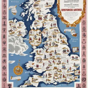
Ireland between Londonderry and Dublin, 1595 (linen, paper)
7339818 Ireland between Londonderry and Dublin, 1595 (linen, paper) by Thomas, John (16th century); 104x113.5 cm; National Maritime Museum, London, UK; (add.info.: Creator: Ihon Thomas
Scale: [ca. 1:150 000]. Cartographic Note: North at 90 degrees. In the scale cartouche text box the surveyor states that his map shows only what he has himself surveyed and expresses a willingness to survey the whole of Ireland. The coat of arms of Lord Burghley is also depicted. The map was drawn early in the Nine Years Rebellion led by Hugh O'Neill against the English. John Thomas, a soldier, also drew plans of the Battle of Belleek and siege of Enniskillen in 1594. Belleek is captioned on this map: ye fourde where Sr Henry Bagnall marshall of her Maj Army of Ireland went over & gave the over througe unto ye traytor maggyer [McGuire]'. Near Enniskillen ye fount wherin fresh beaved her maj forces is marked. From volume eight, Maps of Ireland, of the Dartmouth collection of maps and plans, compiled for or by George Legge, Master General of the Ordnance.); © National Maritime Museum, Greenwich, London
Media ID 38410142
© © National Maritime Museum, Greenwich, London / Bridgeman Images
27x27 inch Poster Print
Step into the past with our Media Storehouse range of Poster Prints! This stunning piece by Bridgeman Images from Fine Art Finder features 'Ireland between Londonderry and Dublin, 1595' - a beautiful illustration that captures the essence of Ireland's rich history. Printed on high-quality paper, this poster is perfect for anyone who loves art, history or simply wants to add some elegance to their home decor.
Poster prints are budget friendly enlarged prints in standard poster paper sizes. Printed on 150 gsm Matte Paper for a natural feel and supplied rolled in a tube. Great for framing and should last many years. To clean wipe with a microfiber, non-abrasive cloth or napkin. Our Archival Quality Photo Prints and Fine Art Paper Prints are printed on higher quality paper and the choice of which largely depends on your budget.
Poster prints are budget friendly enlarged prints in standard poster paper sizes (A0, A1, A2, A3 etc). Whilst poster paper is sometimes thinner and less durable than our other paper types, they are still ok for framing and should last many years. Our Archival Quality Photo Prints and Fine Art Paper Prints are printed on higher quality paper and the choice of which largely depends on your budget.
Estimated Product Size is 69.2cm x 69.2cm (27.2" x 27.2")
These are individually made so all sizes are approximate
Artwork printed orientated as per the preview above, with landscape (horizontal) or portrait (vertical) orientation to match the source image.
FEATURES IN THESE COLLECTIONS
> Fine Art Finder
> Artists
> John Thomas Serres
> Fine Art Finder
> Artists
> Thomas Baxter
> Arts
> Artists
> H
> Thomas Henry
> Arts
> Artists
> N
> Thomas North
> Europe
> Republic of Ireland
> Dublin
> Europe
> Republic of Ireland
> Maps
> Europe
> United Kingdom
> England
> London
> Boroughs
> Greenwich
> Europe
> United Kingdom
> England
> London
> Museums
> Greenwich Heritage Centre
> Europe
> United Kingdom
> England
> London
> Museums
> National Army Museum
> Europe
> United Kingdom
> England
> London
> Museums
> National Maritime Museum
> Europe
> United Kingdom
> England
> London
> Towns
> Greenwich
> Europe
> United Kingdom
> Heritage Sites
> Maritime Greenwich
EDITORS COMMENTS
This stunning print captures a historical map of Ireland between Londonderry and Dublin from 1595, created by John Thomas. The map, made on linen and paper, measures 104x113.5 cm and is housed in the National Maritime Museum in London.
The intricate details of the map reveal a snapshot of Ireland during a tumultuous time - the Nine Years Rebellion led by Hugh O'Neill against English rule. The scale cartouche notes that only areas personally surveyed are depicted, with an offer to survey the entire country.
Notable features include the coat of arms of Lord Burghley and references to key events such as the Battle of Belleek and siege of Enniskillen in 1594. Belleek is labeled as 'ye fourde where Sr Henry Bagnall marshall of her Maj Army of Ireland went over & gave the over througe unto ye traytor maggyer [McGuire],' providing insight into military movements during this period.
This print offers a glimpse into Irish history at a pivotal moment, showcasing both geographical accuracy and political significance. It serves as a valuable piece for those interested in cartography, military history, or the complex relationship between England and Ireland in the late 16th century.
MADE IN THE USA
Safe Shipping with 30 Day Money Back Guarantee
FREE PERSONALISATION*
We are proud to offer a range of customisation features including Personalised Captions, Color Filters and Picture Zoom Tools
SECURE PAYMENTS
We happily accept a wide range of payment options so you can pay for the things you need in the way that is most convenient for you
* Options may vary by product and licensing agreement. Zoomed Pictures can be adjusted in the Cart.