Poster Print > North America > United States of America > Virginia > Hampton
Poster Print : Map of the Battle of Hampton Roads


![]()
Poster Prints from Fine Art Storehouse
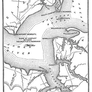
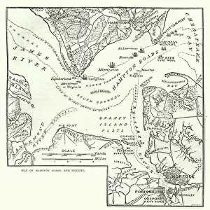
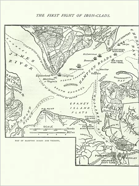
Map of the Battle of Hampton Roads
Vintage engraving of a Map of the Battle of Hampton Roads, often referred to as either the Battle of the Monitor and Merrimack (or Virginia) or the Battle of Ironclads, was the most noted and arguably most important naval battle of the American Civil War
Unleash your creativity and transform your space into a visual masterpiece!
duncan1890
Media ID 14756718
© This content is subject to copyright
Mid Atlantic Usa Paper Based Equipment Battle Of Hampton Roads
18x24 inch Poster Print
Introducing the captivating "Map of the Battle of Hampton Roads" print from our Media Storehouse collection, brought to you by the talented artist duncan1890 from Fine Art Storehouse. This vintage engraving transports you back in time to the historic clash between the Monitor and Merrimack, also known as the Battle of Ironclads or the Battle of the Monitor and Merrimack (or Virginia). Delve into the intricacies of this pivotal moment in naval warfare history with this stunning, intricately detailed map print. Elevate your home or office decor with this unique piece, sure to spark conversation and add character to any space. Order now and let history come alive in your very own home!
Poster prints are budget friendly enlarged prints in standard poster paper sizes. Printed on 150 gsm Matte Paper for a natural feel and supplied rolled in a tube. Great for framing and should last many years. To clean wipe with a microfiber, non-abrasive cloth or napkin. Our Archival Quality Photo Prints and Fine Art Paper Prints are printed on higher quality paper and the choice of which largely depends on your budget.
Poster prints are budget friendly enlarged prints in standard poster paper sizes (A0, A1, A2, A3 etc). Whilst poster paper is sometimes thinner and less durable than our other paper types, they are still ok for framing and should last many years. Our Archival Quality Photo Prints and Fine Art Paper Prints are printed on higher quality paper and the choice of which largely depends on your budget.
Estimated Product Size is 46.3cm x 61.6cm (18.2" x 24.3")
These are individually made so all sizes are approximate
Artwork printed orientated as per the preview above, with portrait (vertical) orientation to match the source image.
FEATURES IN THESE COLLECTIONS
> Fine Art Storehouse
> History
> Battles & Wars
> American Civil War (1860-1865)
> Fine Art Storehouse
> History
> Battles & Wars
> Historcal Battle Maps and Plans
> Fine Art Storehouse
> Map
> Historical Maps
> Fine Art Storehouse
> Map
> USA Maps
> Historic
> Battles
> Related Images
> Maps and Charts
> Related Images
> North America
> United States of America
> Maps
> North America
> United States of America
> Virginia
> Hampton
> North America
> United States of America
> Virginia
> Related Images
EDITORS COMMENTS
This vintage engraving of the Map of the Battle of Hampton Roads takes us back to a pivotal moment in American history. The battle, also known as the Battle of the Monitor and Merrimack or Virginia, was a groundbreaking naval encounter during the American Civil War. This print beautifully captures the essence of this historic event. The image showcases intricate details that bring to life the mid-Atlantic region where this epic clash took place. With paper-based equipment at their disposal, both sides engaged in an intense struggle for dominance on these very waters. The map highlights strategic positions and maneuvers undertaken by each vessel involved, providing a comprehensive overview of this significant engagement. Considered one of the most important naval battles in American history, it forever changed warfare tactics with its introduction of ironclad warships. As we gaze upon this remarkable piece, we are reminded not only of its historical significance but also its artistic value. Duncan1890's masterful reproduction allows us to appreciate every line and contour meticulously etched into this print. It serves as a testament to his dedication in preserving such crucial moments from our past through artistry. Whether you are an avid historian or simply captivated by stunning artwork, this Map of the Battle of Hampton Roads is sure to ignite your imagination and transport you back to a time when two iron behemoths clashed amidst swirling currents and billowing smoke.
MADE IN THE USA
Safe Shipping with 30 Day Money Back Guarantee
FREE PERSONALISATION*
We are proud to offer a range of customisation features including Personalised Captions, Color Filters and Picture Zoom Tools
SECURE PAYMENTS
We happily accept a wide range of payment options so you can pay for the things you need in the way that is most convenient for you
* Options may vary by product and licensing agreement. Zoomed Pictures can be adjusted in the Cart.