Poster Print > North America > United States of America > Maps
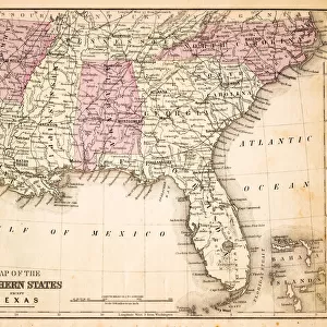
Poster Print : Map of Railroads USA 1883


![]()
Poster Prints from Fine Art Storehouse
Map of Railroads USA 1883
Warrens Common School Geography
Unleash your creativity and transform your space into a visual masterpiece!
THEPALMER
Media ID 13669349
© This content is subject to copyright
North America Paper Rail Transportation Railroad Track
18x24 inch Poster Print
Step back in time with our exquisite 'Map of Railroads USA 1883' by THEPALMER from the Media Storehouse Fine Art Storehouse collection. This captivating poster print showcases the intricate railroad network of the United States as it existed in 1883, offering a fascinating glimpse into the country's history. Ideal for history enthusiasts, educators, or anyone with a passion for vintage maps, this beautifully detailed print is sure to make a striking addition to any room. Bring history to life with this unique piece from Media Storehouse.
Poster prints are budget friendly enlarged prints in standard poster paper sizes. Printed on 150 gsm Matte Paper for a natural feel and supplied rolled in a tube. Great for framing and should last many years. To clean wipe with a microfiber, non-abrasive cloth or napkin. Our Archival Quality Photo Prints and Fine Art Paper Prints are printed on higher quality paper and the choice of which largely depends on your budget.
Poster prints are budget friendly enlarged prints in standard poster paper sizes (A0, A1, A2, A3 etc). Whilst poster paper is sometimes thinner and less durable than our other paper types, they are still ok for framing and should last many years. Our Archival Quality Photo Prints and Fine Art Paper Prints are printed on higher quality paper and the choice of which largely depends on your budget.
Estimated Product Size is 61.6cm x 46.3cm (24.3" x 18.2")
These are individually made so all sizes are approximate
Artwork printed orientated as per the preview above, with landscape (horizontal) orientation to match the source image.
FEATURES IN THESE COLLECTIONS
> Fine Art Storehouse
> The Magical World of Illustration
> Palmer Illustrated Collection
> Fine Art Storehouse
> Map
> Historical Maps
> Fine Art Storehouse
> Map
> USA Maps
> Maps and Charts
> Related Images
> North America
> Related Images
> North America
> United States of America
> Maps
EDITORS COMMENTS
This print titled "Map of Railroads USA 1883" takes us on a journey back in time to the late 19th century. A relic from Warrens Common School Geography, this horizontal image showcases the intricate network of railroads that crisscrossed the vast expanse of North America's United States. Printed on aged paper, this antique map carries an air of nostalgia and historical significance. The meticulously engraved illustration captures every detail of the railroad tracks, showcasing their importance in shaping America's physical geography during that era. The artistry behind this piece is evident in its exquisite cartography and precision engraving. It serves as a testament to the skillful craftsmanship that went into creating such comprehensive maps before modern technology took over. As we gaze upon this remarkable image, we are transported to a time when rail transportation was at its peak, connecting cities and towns across the nation like never before. It reminds us of how these iron arteries transformed not only travel but also trade and communication throughout America. "The Map of Railroads USA 1883" by THEPALMER invites us to appreciate both the beauty and historical significance embedded within old maps. This stunning print serves as a reminder of our past while igniting curiosity about how far we have come since those early days of rail transportation.
MADE IN THE USA
Safe Shipping with 30 Day Money Back Guarantee
FREE PERSONALISATION*
We are proud to offer a range of customisation features including Personalised Captions, Color Filters and Picture Zoom Tools
SECURE PAYMENTS
We happily accept a wide range of payment options so you can pay for the things you need in the way that is most convenient for you
* Options may vary by product and licensing agreement. Zoomed Pictures can be adjusted in the Cart.