Poster Print > Europe > United Kingdom > England > Maps
Poster Print : 1643, antiquity, archival, british isles, cartography, england, europe, geographical


![]()
Poster Prints from Fine Art Storehouse
1643, antiquity, archival, british isles, cartography, england, europe, geographical
1643, antiquity, archival, british isles, cartography, england, europe, geographical, geography, historical, map, nobody, old-fashioned, text, uk, vintage, Antique Maps, 89687337
Unleash your creativity and transform your space into a visual masterpiece!
Hemera Technologies
Media ID 14761238
© Getty Images
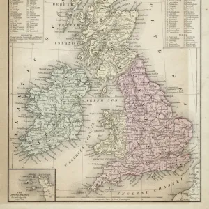
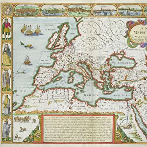
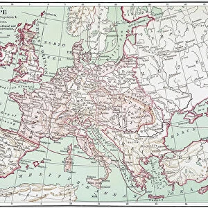
Antiquity British Isles Geographical Geography Text 1643
18x24 inch Poster Print
"Step back in time with our exquisite selection of antique poster prints from Media Storehouse, featuring this captivating map of the British Isles from 1643. This archival piece showcases the rich cartographic history of Europe, with intricate details and text that transport you back to the old-fashioned charm of England during the 17th century. The vintage map, with its aged appearance and intriguing geographical information, adds an authentic and historical touch to any room. Perfect for those who appreciate the beauty of the past, this geographical masterpiece is a must-have for collectors and enthusiasts alike."
Poster prints are budget friendly enlarged prints in standard poster paper sizes. Printed on 150 gsm Matte Paper for a natural feel and supplied rolled in a tube. Great for framing and should last many years. To clean wipe with a microfiber, non-abrasive cloth or napkin. Our Archival Quality Photo Prints and Fine Art Paper Prints are printed on higher quality paper and the choice of which largely depends on your budget.
Poster prints are budget friendly enlarged prints in standard poster paper sizes (A0, A1, A2, A3 etc). Whilst poster paper is sometimes thinner and less durable than our other paper types, they are still ok for framing and should last many years. Our Archival Quality Photo Prints and Fine Art Paper Prints are printed on higher quality paper and the choice of which largely depends on your budget.
Estimated Product Size is 61.6cm x 46.3cm (24.3" x 18.2")
These are individually made so all sizes are approximate
Artwork printed orientated as per the preview above, with landscape (horizontal) orientation to match the source image.
FEATURES IN THESE COLLECTIONS
> Fine Art Storehouse
> Map
> Historical Maps
> Europe
> United Kingdom
> England
> Maps
> Europe
> United Kingdom
> England
> Posters
> Europe
> United Kingdom
> Maps
> Maps and Charts
> Early Maps
> Maps and Charts
> Related Images
EDITORS COMMENTS
This print takes us back in time to the year 1643, immersing us in the antiquity and historical significance of the British Isles. The archival map, meticulously crafted with cartography expertise, showcases England and its place within Europe. Its vintage charm is evident through its old-fashioned text and intricate details that transport us to a bygone era. The map's geographical accuracy offers a glimpse into the past, allowing us to explore the landscapes and boundaries as they were centuries ago. It serves as a valuable resource for historians, researchers, or anyone with an interest in understanding how the British Isles fit into Europe's tapestry during this period. The absence of people in this image emphasizes its focus on geography rather than human activity. Instead, our attention is drawn to every line and contour that forms this remarkable piece of artistry. As we delve deeper into its rich history, we can appreciate both the craftsmanship behind it and Hemera Technologies' commitment to preserving these antique maps. Whether displayed in a personal collection or used for educational purposes, this print from Fine Art Storehouse captures not only an exquisite piece of cartographic heritage but also invites viewers to embark on a journey through time itself.
MADE IN THE USA
Safe Shipping with 30 Day Money Back Guarantee
FREE PERSONALISATION*
We are proud to offer a range of customisation features including Personalised Captions, Color Filters and Picture Zoom Tools
SECURE PAYMENTS
We happily accept a wide range of payment options so you can pay for the things you need in the way that is most convenient for you
* Options may vary by product and licensing agreement. Zoomed Pictures can be adjusted in the Cart.