Poster Print > North America > Related Images
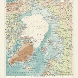
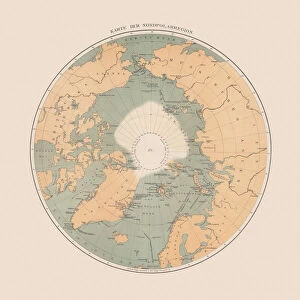
Poster Print : Historic Map of the Arctic, wood engraving, published in 1882


![]()
Poster Prints from Fine Art Storehouse
Historic Map of the Arctic, wood engraving, published in 1882
Historic Map of the Arctic. Wood engraving, published in 1882
Unleash your creativity and transform your space into a visual masterpiece!
Media ID 14756506
© This content is subject to copyright
Alaska America American Asian Canada Circle Globe Greenland Historically Island Norway Polar Russia Russian Scandinavia Siberia Square Wood Engraving Asien Geschichte Globus Gravur Gronland Historisch Nordamerika Northwest Passage Norwegen Spitzbergen Stich
27x27 inch Poster Print
Step back in time with our Historic Map of the Arctic print from the Media Storehouse Fine Art collection. This exquisite wood engraving, published in 1882, offers a captivating glimpse into the exploration and discovery of the Arctic region during the late 19th century. With intricate details and vivid colors, this historic map print adds an air of sophistication and history to any space. Ideal for avid collectors, history enthusiasts, or those seeking to add a touch of antiquity to their home or office decor. Bring the past to life with our Historic Map of the Arctic print from Media Storehouse Fine Art Storehouse.
Poster prints are budget friendly enlarged prints in standard poster paper sizes. Printed on 150 gsm Matte Paper for a natural feel and supplied rolled in a tube. Great for framing and should last many years. To clean wipe with a microfiber, non-abrasive cloth or napkin. Our Archival Quality Photo Prints and Fine Art Paper Prints are printed on higher quality paper and the choice of which largely depends on your budget.
Poster prints are budget friendly enlarged prints in standard poster paper sizes (A0, A1, A2, A3 etc). Whilst poster paper is sometimes thinner and less durable than our other paper types, they are still ok for framing and should last many years. Our Archival Quality Photo Prints and Fine Art Paper Prints are printed on higher quality paper and the choice of which largely depends on your budget.
Estimated Product Size is 69.2cm x 69.2cm (27.2" x 27.2")
These are individually made so all sizes are approximate
Artwork printed orientated as per the preview above, with landscape (horizontal) or portrait (vertical) orientation to match the source image.
FEATURES IN THESE COLLECTIONS
> Fine Art Storehouse
> Map
> Historical Maps
> Asia
> Related Images
> Europe
> Russia
> Related Images
> North America
> Related Images
EDITORS COMMENTS
This wood engraving, a historic map of the Arctic, takes us back to 1882 when exploration and discovery were at their peak. The intricate details etched into this print transport us to a time when the vast icy landscapes of the Arctic remained largely uncharted. The map showcases the immense expanse of this polar region, stretching from Greenland in the west to Russia in the east. It highlights significant landmarks such as Alaska, Canada, Scandinavia, Spitzbergen, and even parts of Asia. This comprehensive depiction allows us to appreciate how interconnected these regions are despite their geographical distance. As we gaze upon this ancient cartographic masterpiece, it is impossible not to feel a sense of awe for those intrepid explorers who braved treacherous conditions in search of new trade routes or scientific knowledge. The Northwest Passage is prominently featured on this map—a legendary route that captivated many adventurers throughout history. The square shape adds an element of uniqueness to this wood engraving while emphasizing its historical significance. Each line and curve meticulously carved into the woodcut tells a story waiting to be discovered by curious minds. Whether you are an enthusiast fascinated by history or simply drawn towards antique art forms like engravings and prints, this piece will undoubtedly become a cherished addition to your collection. Let yourself be transported through time as you explore every inch of this remarkable historic map capturing both imagination and curiosity alike.
MADE IN THE USA
Safe Shipping with 30 Day Money Back Guarantee
FREE PERSONALISATION*
We are proud to offer a range of customisation features including Personalised Captions, Color Filters and Picture Zoom Tools
SECURE PAYMENTS
We happily accept a wide range of payment options so you can pay for the things you need in the way that is most convenient for you
* Options may vary by product and licensing agreement. Zoomed Pictures can be adjusted in the Cart.