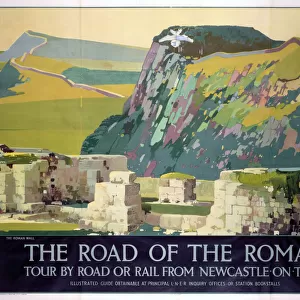
Poster Print > Historic > Ancient civilizations > Roman Empire > Roman art
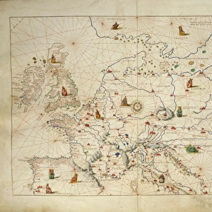
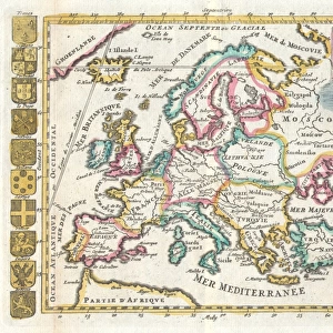
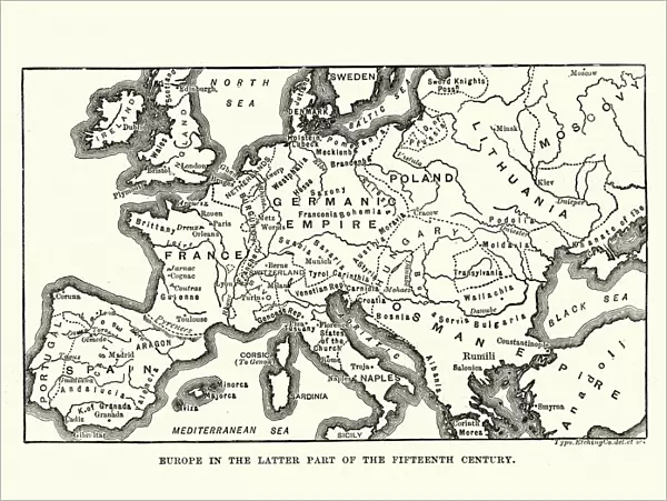
Poster Print : Map of Europe in late 15th Century


![]()
Poster Prints from Fine Art Storehouse
Map of Europe in late 15th Century
Vintage engraving of a Map of Europe in late 15th Century
Unleash your creativity and transform your space into a visual masterpiece!
duncan1890
Media ID 14756500
© This content is subject to copyright
15th Century Empire Equipment Medieval Middle Ages Navigational Equipment News Retro Styles Supplies Holy Roman Empire
18x24 inch Poster Print
Step back in time with our exquisite Map of Europe in late 15th Century print from the Media Storehouse collection. This vintage engraving, sourced from the Fine Art Storehouse, offers a captivating glimpse into the historical geography of Europe during an era of exploration and discovery. The intricate details of the map, created by artist duncan1890, transport you back to a time of kings, queens, and great empires. Add this beautiful and educational piece to your home or office to inspire curiosity and ignite conversations about the rich history of our continent.
Poster prints are budget friendly enlarged prints in standard poster paper sizes. Printed on 150 gsm Matte Paper for a natural feel and supplied rolled in a tube. Great for framing and should last many years. To clean wipe with a microfiber, non-abrasive cloth or napkin. Our Archival Quality Photo Prints and Fine Art Paper Prints are printed on higher quality paper and the choice of which largely depends on your budget.
Poster prints are budget friendly enlarged prints in standard poster paper sizes (A0, A1, A2, A3 etc). Whilst poster paper is sometimes thinner and less durable than our other paper types, they are still ok for framing and should last many years. Our Archival Quality Photo Prints and Fine Art Paper Prints are printed on higher quality paper and the choice of which largely depends on your budget.
Estimated Product Size is 61.6cm x 46.3cm (24.3" x 18.2")
These are individually made so all sizes are approximate
Artwork printed orientated as per the preview above, with landscape (horizontal) orientation to match the source image.
FEATURES IN THESE COLLECTIONS
> Fine Art Storehouse
> Map
> Historical Maps
> Arts
> Art Movements
> Medieval Art
> Arts
> Artists
> R
> Roman Roman
> Historic
> Ancient civilizations
> Roman Empire
> Roman art
> Historic
> Historical fashion trends
> Medieval fashion trends
> Maps and Charts
> Related Images
EDITORS COMMENTS
This vintage engraving of a Map of Europe in the late 15th Century takes us on a journey back in time. With its intricate details and black-and-white aesthetic, it offers a glimpse into the cartographic techniques used during this era. The map showcases the vast European continent as it was known centuries ago, with various kingdoms, empires, and territories clearly outlined. As we examine this print closely, we are transported to an age where navigational equipment was rudimentary yet essential for exploration and trade. The woodcut style adds an authentic touch to the illustration, reminding us of the craftsmanship involved in creating such maps during medieval times. The Holy Roman Empire stands out prominently on this map, symbolizing its dominance over much of Central Europe at that period. It serves as a reminder of the complex political landscape that shaped history during those times. This print evokes nostalgia for bygone eras and invites us to reflect on how our understanding of geography has evolved over time. It is not just a piece of art but also a historical artifact that tells stories about ancient civilizations and their interconnectedness. Duncan1890's work captures both the beauty and significance of this antique map, allowing us to appreciate its rich historical context while adding a touch of retro charm to any setting.
MADE IN THE USA
Safe Shipping with 30 Day Money Back Guarantee
FREE PERSONALISATION*
We are proud to offer a range of customisation features including Personalised Captions, Color Filters and Picture Zoom Tools
SECURE PAYMENTS
We happily accept a wide range of payment options so you can pay for the things you need in the way that is most convenient for you
* Options may vary by product and licensing agreement. Zoomed Pictures can be adjusted in the Cart.