Poster Print > North America > United States of America > New York > New York > Maps
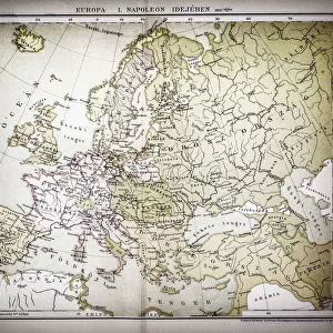
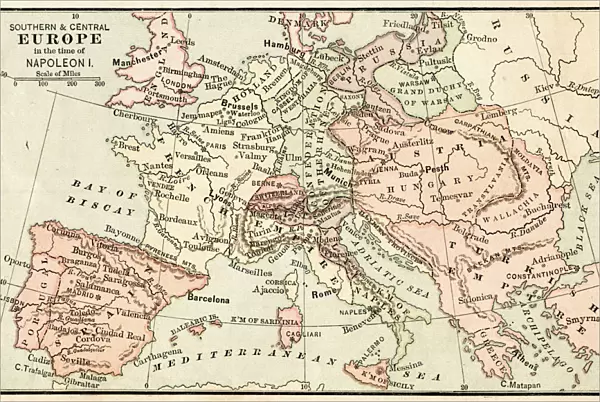
Poster Print : Map of Europe in the time of Napoleon I 1881

![]()
Poster Prints from Fine Art Storehouse
Map of Europe in the time of Napoleon I 1881
Appletons American Standard Geographies - New York 1881 - d. Appleton and Company
Unleash your creativity and transform your space into a visual masterpiece!
THEPALMER
Media ID 18442883
© 2014 Roberto Adrian Photography
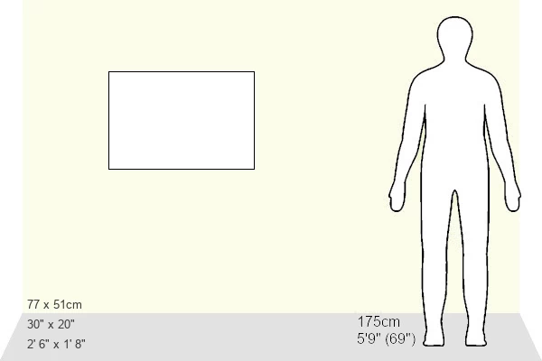
20x30 inch Poster Print
Step back in time with our captivating Map of Europe in the Time of Napoleon I, a stunning poster print from ThePalmer's Fine Art Storehouse collection. This exquisite piece is based on the 1881 Appleton's American Standard Geographies map published by D. Appleton and Company. The intricate details of European borders and territories during Napoleon's reign provide a captivating glimpse into history. Bring this piece into your home or office to inspire curiosity and ignite conversations about the past. Each print is meticulously produced using high-quality materials, ensuring a vibrant and long-lasting display. Elevate your space with a touch of history and culture.
Poster prints are budget friendly enlarged prints in standard poster paper sizes. Printed on 150 gsm Matte Paper for a natural feel and supplied rolled in a tube. Great for framing and should last many years. To clean wipe with a microfiber, non-abrasive cloth or napkin. Our Archival Quality Photo Prints and Fine Art Paper Prints are printed on higher quality paper and the choice of which largely depends on your budget.
Poster prints are budget friendly enlarged prints in standard poster paper sizes (A0, A1, A2, A3 etc). Whilst poster paper is sometimes thinner and less durable than our other paper types, they are still ok for framing and should last many years. Our Archival Quality Photo Prints and Fine Art Paper Prints are printed on higher quality paper and the choice of which largely depends on your budget.
Estimated Product Size is 76.8cm x 51.4cm (30.2" x 20.2")
These are individually made so all sizes are approximate
Artwork printed orientated as per the preview above, with landscape (horizontal) or portrait (vertical) orientation to match the source image.
FEATURES IN THESE COLLECTIONS
> Fine Art Storehouse
> Map
> Historical Maps
> Europe
> Related Images
> Maps and Charts
> Related Images
> North America
> United States of America
> New York
> New York
> Maps
> North America
> United States of America
> New York
> Related Images
EDITORS COMMENTS
In this print titled "Map of Europe in the time of Napoleon I 1881" we are transported back to a pivotal era in European history. The image, sourced from Appletons American Standard Geographies - New York 1881 by d. Appleton and Company, offers a glimpse into the geopolitical landscape during the reign of Napoleon Bonaparte. The map itself is a testament to both artistry and historical accuracy, showcasing intricate details that bring the past to life. As our eyes wander across its surface, we can trace the borders of various nations as they existed at that time – France under Napoleon's rule dominating much of continental Europe, while other powers such as Britain, Austria, Prussia, and Russia jostle for their own spheres of influence. This particular print captures not only an important moment in European history but also serves as a reminder of how cartography has evolved over time. It showcases the craftsmanship involved in creating detailed maps before modern technology made it more accessible. "The Map of Europe in the time of Napoleon I" invites us to reflect on how political boundaries have shifted throughout history and encourages us to delve deeper into understanding this transformative period. Its presence adds depth and character to any space it graces while serving as a visual gateway into an intriguing chapter from our collective past.
MADE IN THE USA
Safe Shipping with 30 Day Money Back Guarantee
FREE PERSONALISATION*
We are proud to offer a range of customisation features including Personalised Captions, Color Filters and Picture Zoom Tools
SECURE PAYMENTS
We happily accept a wide range of payment options so you can pay for the things you need in the way that is most convenient for you
* Options may vary by product and licensing agreement. Zoomed Pictures can be adjusted in the Cart.