Poster Print > Europe > France > Maps
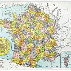
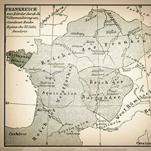
Poster Print : Map of France 1886


![]()
Poster Prints from Fine Art Storehouse
Map of France 1886
Map of France Maps Monteith Physical Geography 1886
Unleash your creativity and transform your space into a visual masterpiece!
THEPALMER
Media ID 14756944
© This content is subject to copyright
18x24 inch Poster Print
"Step back in time with our exquisite Map of France 1886 print from THEPALMER at Media Storehouse. This stunning piece of historical cartography, sourced from the esteemed Fine Art Storehouse, showcases the geographical layout of France during the late 19th century. With intricate detail and vibrant colors, this poster print is a captivating addition to any home or office space, transporting you back to an era of exploration and discovery. Bring a touch of history and charm to your walls with this beautifully preserved piece from the Monteith Physical Geography series."
Poster prints are budget friendly enlarged prints in standard poster paper sizes. Printed on 150 gsm Matte Paper for a natural feel and supplied rolled in a tube. Great for framing and should last many years. To clean wipe with a microfiber, non-abrasive cloth or napkin. Our Archival Quality Photo Prints and Fine Art Paper Prints are printed on higher quality paper and the choice of which largely depends on your budget.
Poster prints are budget friendly enlarged prints in standard poster paper sizes (A0, A1, A2, A3 etc). Whilst poster paper is sometimes thinner and less durable than our other paper types, they are still ok for framing and should last many years. Our Archival Quality Photo Prints and Fine Art Paper Prints are printed on higher quality paper and the choice of which largely depends on your budget.
Estimated Product Size is 61.6cm x 46.3cm (24.3" x 18.2")
These are individually made so all sizes are approximate
Artwork printed orientated as per the preview above, with landscape (horizontal) orientation to match the source image.
FEATURES IN THESE COLLECTIONS
> Fine Art Storehouse
> Map
> Historical Maps
> Maps and Charts
> Related Images
EDITORS COMMENTS
In this print titled "Map of France 1886" we are transported back in time to the late 19th century. The map, originally published as part of the Monteith Physical Geography collection, offers a fascinating glimpse into the intricate details and artistic craftsmanship of cartography during that era. The carefully drawn lines and delicate shading bring forth a sense of nostalgia, reminding us of an age when maps were meticulously handcrafted works of art. As our eyes wander across the image, we can trace the borders and contours that define France's diverse landscapes – from its majestic mountain ranges to its meandering rivers and picturesque coastlines. This particular rendition captures France at a significant moment in history. It allows us to explore not only its geographical features but also provides insights into political boundaries and regional divisions prevalent during that period. Each city, town, and village is marked with precision, inviting us to embark on a journey through time as we imagine life in these different regions over a century ago. "The Map of France 1886" by THEPALMER serves as both an educational tool for geography enthusiasts and an exquisite piece of artwork for collectors. Its historical significance combined with its aesthetic appeal makes it a timeless addition to any space – be it your study or living room – where it can spark conversations about history, culture, or simply ignite one's imagination about exploring the beautiful country depicted within its borders.
MADE IN THE USA
Safe Shipping with 30 Day Money Back Guarantee
FREE PERSONALISATION*
We are proud to offer a range of customisation features including Personalised Captions, Color Filters and Picture Zoom Tools
SECURE PAYMENTS
We happily accept a wide range of payment options so you can pay for the things you need in the way that is most convenient for you
* Options may vary by product and licensing agreement. Zoomed Pictures can be adjusted in the Cart.