Poster Print > Asia > India > Maps
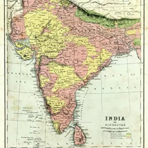
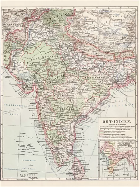
Poster Print : Map of India 1900


![]()
Poster Prints from Fine Art Storehouse
Map of India 1900
Meyers hand-Atlas Leipzig und Wien Verlag des Bibliographischen Instituts 1900
Unleash your creativity and transform your space into a visual masterpiece!
THEPALMER
Media ID 18106853
© 2014 Roberto Adrian Photography
18x24 inch Poster Print
Discover history with our exquisite Map of India 1900 print from THEPALMER's Fine Art Storehouse. This stunning piece is taken from the renowned Meyers Hand-Atlas published by Bibliographisches Institut Leipzig und Wien Verlag in 1900. Travel back in time and explore the intricacies of India's geography as it existed over a century ago. Add this captivating work of art to your home or office to ignite conversations and inspire curiosity. Each print is meticulously produced using high-quality materials to ensure a vibrant and long-lasting display. Bring a piece of historical cartography into your space and elevate your decor with our Map of India 1900 print from the Media Storehouse collection.
Poster prints are budget friendly enlarged prints in standard poster paper sizes. Printed on 150 gsm Matte Paper for a natural feel and supplied rolled in a tube. Great for framing and should last many years. To clean wipe with a microfiber, non-abrasive cloth or napkin. Our Archival Quality Photo Prints and Fine Art Paper Prints are printed on higher quality paper and the choice of which largely depends on your budget.
Poster prints are budget friendly enlarged prints in standard poster paper sizes (A0, A1, A2, A3 etc). Whilst poster paper is sometimes thinner and less durable than our other paper types, they are still ok for framing and should last many years. Our Archival Quality Photo Prints and Fine Art Paper Prints are printed on higher quality paper and the choice of which largely depends on your budget.
Estimated Product Size is 46.3cm x 61.6cm (18.2" x 24.3")
These are individually made so all sizes are approximate
Artwork printed orientated as per the preview above, with portrait (vertical) orientation to match the source image.
FEATURES IN THESE COLLECTIONS
> Fine Art Storehouse
> Map
> Historical Maps
> Asia
> India
> Related Images
> Maps and Charts
> India
EDITORS COMMENTS
In this print titled "Map of India 1900". THEPALMER takes us on a journey back in time to the turn of the 20th century. The map, sourced from Meyers hand-Atlas Leipzig und Wien Verlag des Bibliographischen Instituts 1900, offers a glimpse into the intricate details and artistry that went into cartography during that era. The image showcases an exquisite blend of vibrant colors and meticulous craftsmanship, capturing the essence of India's diverse landscape. From the majestic peaks of the Himalayas to the vast plains and fertile river valleys, every contour is delicately etched onto this historical piece. As we explore this vintage map, our eyes are drawn to various cities and regions marked with precision. Each name tells a story - evoking images of bustling marketplaces, ancient temples, and rich cultural heritage. It serves as a reminder of India's deep-rooted history and its significance as one of the world's oldest civilizations. Beyond its aesthetic appeal lies an educational treasure trove for geography enthusiasts or anyone curious about India's past. This artwork invites us to immerse ourselves in an era when maps were not just navigational tools but also works of art. "The Map of India 1900" by THEPALMER is more than just a decorative piece; it encapsulates nostalgia for an era gone by while offering valuable insights into Indian geography at that time. Whether displayed in homes or educational institutions, this print sparks curiosity and appreciation for both artistic expression
MADE IN THE USA
Safe Shipping with 30 Day Money Back Guarantee
FREE PERSONALISATION*
We are proud to offer a range of customisation features including Personalised Captions, Color Filters and Picture Zoom Tools
SECURE PAYMENTS
We happily accept a wide range of payment options so you can pay for the things you need in the way that is most convenient for you
* Options may vary by product and licensing agreement. Zoomed Pictures can be adjusted in the Cart.