Poster Print > Europe > Italy > Lazio > Rome
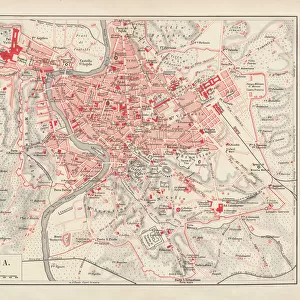
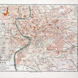
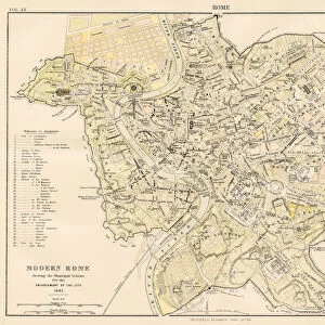
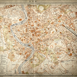
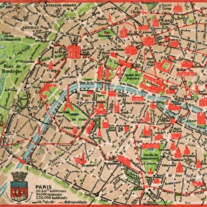
Poster Print : Map of Rome 1900


![]()
Poster Prints from Fine Art Storehouse
Map of Rome 1900
Meyers hand-Atlas Leipzig und Wien Verlag des Bibliographischen Instituts 1900
Unleash your creativity and transform your space into a visual masterpiece!
THEPALMER
Media ID 18106911
© 2014 Roberto Adrian Photography
18x24 inch Poster Print
Step back in time with our exquisite 'Map of Rome 1900' poster print from THEPALMER at Media Storehouse. This stunning piece is taken from the Meyers Hand-Atlas, published by the Bibliographisches Institut in Leipzig and Wien in 1900. Immerse yourself in the historical detail and intricate cartography of this iconic map, which captures Rome in a moment in time. Bring a piece of the past into your home or office and transport yourself on a journey through history with every glance. Order your 'Map of Rome 1900' poster print today from the Fine Art Storehouse at Media Storehouse.
Poster prints are budget friendly enlarged prints in standard poster paper sizes. Printed on 150 gsm Matte Paper for a natural feel and supplied rolled in a tube. Great for framing and should last many years. To clean wipe with a microfiber, non-abrasive cloth or napkin. Our Archival Quality Photo Prints and Fine Art Paper Prints are printed on higher quality paper and the choice of which largely depends on your budget.
Poster prints are budget friendly enlarged prints in standard poster paper sizes (A0, A1, A2, A3 etc). Whilst poster paper is sometimes thinner and less durable than our other paper types, they are still ok for framing and should last many years. Our Archival Quality Photo Prints and Fine Art Paper Prints are printed on higher quality paper and the choice of which largely depends on your budget.
Estimated Product Size is 61.6cm x 46.3cm (24.3" x 18.2")
These are individually made so all sizes are approximate
Artwork printed orientated as per the preview above, with landscape (horizontal) orientation to match the source image.
FEATURES IN THESE COLLECTIONS
> Fine Art Storehouse
> Map
> Historical Maps
> Europe
> Italy
> Lazio
> Rome
EDITORS COMMENTS
In this print titled "Map of Rome 1900". THEPALMER takes us on a journey back in time to the enchanting city of Rome at the turn of the 20th century. The image showcases a meticulously detailed map, sourced from Meyers Hand-Atlas Leipzig und Wien Verlag des Bibliographischen Instituts in 1900. The map itself is a true work of art, displaying an intricate network of streets, landmarks, and historical sites that make up the eternal city. Every corner is filled with delicate lines and labels, inviting viewers to explore its hidden treasures. From the iconic Colosseum to the majestic Vatican City, this vintage map offers a glimpse into Rome's rich history and cultural heritage. THEPALMER's choice to capture this particular piece evokes nostalgia for an era long gone by. The sepia tones lend an air of antiquity while preserving every minute detail with remarkable clarity. This print serves as both a decorative piece and a window into history—a reminder that cities are living organisms constantly evolving through time. Whether you have visited Rome before or dreamt about walking its ancient streets, "Map of Rome 1900" transports you effortlessly into another world. It invites contemplation on how much has changed over the past century while celebrating timeless beauty that continues to captivate travelers from around the globe.
MADE IN THE USA
Safe Shipping with 30 Day Money Back Guarantee
FREE PERSONALISATION*
We are proud to offer a range of customisation features including Personalised Captions, Color Filters and Picture Zoom Tools
SECURE PAYMENTS
We happily accept a wide range of payment options so you can pay for the things you need in the way that is most convenient for you
* Options may vary by product and licensing agreement. Zoomed Pictures can be adjusted in the Cart.