Poster Print > Europe > Italy > Maps
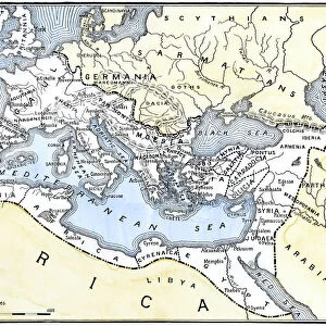
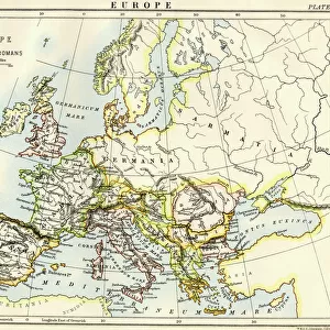
Poster Print : Antique Map of Italy 1732


![]()
Poster Prints from Fine Art Storehouse
Antique Map of Italy 1732
Mediterranean Countries, Antique Maps, 91822666
Unleash your creativity and transform your space into a visual masterpiece!
BernardAllum
Media ID 15311448
© Bernard Allum
18x24 inch Poster Print
"Step back in time with our Antique Map of Italy 1732 from the Media Storehouse collection at Fine Art Storehouse (Item 91822666). This stunning poster print showcases an intricately detailed map of Italy as it appeared over 300 years ago, meticulously crafted by Bernard Allum. Bring the rich history and culture of Mediterranean countries into your home or office with this beautiful and authentic piece of cartographical art. Order your Antique Map of Italy 1732 poster print today and let the stories of the past unfold."
Poster prints are budget friendly enlarged prints in standard poster paper sizes. Printed on 150 gsm Matte Paper for a natural feel and supplied rolled in a tube. Great for framing and should last many years. To clean wipe with a microfiber, non-abrasive cloth or napkin. Our Archival Quality Photo Prints and Fine Art Paper Prints are printed on higher quality paper and the choice of which largely depends on your budget.
Poster prints are budget friendly enlarged prints in standard poster paper sizes (A0, A1, A2, A3 etc). Whilst poster paper is sometimes thinner and less durable than our other paper types, they are still ok for framing and should last many years. Our Archival Quality Photo Prints and Fine Art Paper Prints are printed on higher quality paper and the choice of which largely depends on your budget.
Estimated Product Size is 61.6cm x 46.3cm (24.3" x 18.2")
These are individually made so all sizes are approximate
Artwork printed orientated as per the preview above, with landscape (horizontal) orientation to match the source image.
FEATURES IN THESE COLLECTIONS
> Fine Art Storehouse
> Map
> Historical Maps
> Fine Art Storehouse
> Map
> Italian Maps
> Maps and Charts
> Italy
> Maps and Charts
> Related Images
EDITORS COMMENTS
This print showcases an exquisite "Antique Map of Italy 1732" meticulously crafted by the talented Bernard Allum. Stepping into a world long gone, this piece takes us back to the early 18th century when cartography was both an art form and a scientific pursuit. The map's intricate details transport us to a time where exploration and discovery were at their peak. Italy, with its rich history and cultural heritage, is beautifully depicted in this artwork. From the rolling hills of Tuscany to the majestic peaks of the Alps, every region is intricately illustrated with precision and care. The Mediterranean Sea surrounds this enchanting peninsula, reminding us of Italy's strategic location as a gateway between Europe and Africa. The warm color palette used in this print adds depth and nostalgia to the composition, evoking a sense of antiquity that resonates with history enthusiasts and art lovers alike. As we gaze upon this masterpiece, we can't help but imagine how these maps were once treasured possessions for explorers planning their journeys or scholars seeking knowledge about distant lands. Bernard Allum's attention to detail truly shines through in every stroke of his brush or pen. This print from Fine Art Storehouse allows us to bring home a piece of history while appreciating the beauty inherent in antique maps – not just as navigational tools but also as works of art that transcend time itself.
MADE IN THE USA
Safe Shipping with 30 Day Money Back Guarantee
FREE PERSONALISATION*
We are proud to offer a range of customisation features including Personalised Captions, Color Filters and Picture Zoom Tools
SECURE PAYMENTS
We happily accept a wide range of payment options so you can pay for the things you need in the way that is most convenient for you
* Options may vary by product and licensing agreement. Zoomed Pictures can be adjusted in the Cart.