Poster Print > Oceania > Samoa > Maps
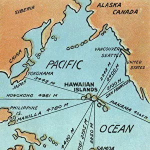
Poster Print : Pacific island Samoa map 1898


![]()
Poster Prints from Fine Art Storehouse
Pacific island Samoa map 1898
Map from Physical Geography by R. S. Tarr - The MacMillan Company - London 1898
Unleash your creativity and transform your space into a visual masterpiece!
THEPALMER
Media ID 20773157
© A 2014 Roberto Adrian Photography
18x24 inch Poster Print
Discover the rich history of Pacific islands with our stunningly detailed and authentic poster print of Samoa from 1898. This captivating map, titled "Physical Geography" and published by The MacMillan Company in London, is a beautiful representation of the region as it appeared over a century ago. Meticulously reproduced from the original work by THEPALMER, this poster print is a must-have for history enthusiasts, cartography collectors, and anyone with a passion for the Pacific. Bring a piece of the past into your home or office and transport yourself to a time of exploration and discovery with our Media Storehouse Samoa Map 1898 poster print.
Poster prints are budget friendly enlarged prints in standard poster paper sizes. Printed on 150 gsm Matte Paper for a natural feel and supplied rolled in a tube. Great for framing and should last many years. To clean wipe with a microfiber, non-abrasive cloth or napkin. Our Archival Quality Photo Prints and Fine Art Paper Prints are printed on higher quality paper and the choice of which largely depends on your budget.
Poster prints are budget friendly enlarged prints in standard poster paper sizes (A0, A1, A2, A3 etc). Whilst poster paper is sometimes thinner and less durable than our other paper types, they are still ok for framing and should last many years. Our Archival Quality Photo Prints and Fine Art Paper Prints are printed on higher quality paper and the choice of which largely depends on your budget.
Estimated Product Size is 46.3cm x 61.6cm (18.2" x 24.3")
These are individually made so all sizes are approximate
Artwork printed orientated as per the preview above, with portrait (vertical) orientation to match the source image.
FEATURES IN THESE COLLECTIONS
> Maps and Charts
> Related Images
EDITORS COMMENTS
In this print titled "Pacific island Samoa map 1898" we are transported back in time to the late 19th century. The image showcases a beautifully detailed map, sourced from the esteemed book "Physical Geography" by R. S. Tarr and published by The MacMillan Company in London, 1898. The map itself is a testament to the artistry and precision of cartography during that era. Every contour line, river, mountain range, and coastal feature has been meticulously drawn with utmost care and accuracy. It serves as a visual representation of the Pacific island nation of Samoa at a significant moment in history. As we gaze upon this vintage piece, our imagination takes flight as we envision explorers poring over similar maps before embarking on daring voyages across vast oceans. We can almost feel their excitement and anticipation for what lies beyond these shores. "The Palmer" an artist associated with Fine Art Storehouse, has skillfully captured this historical artifact through photography, preserving its essence for generations to come. Through his lens, he allows us to appreciate not only the scientific value of such maps but also their aesthetic appeal. This print invites us to delve into the rich tapestry of human exploration and discovery while celebrating the beauty inherent in both nature's landscapes and man-made creations like maps. It serves as a reminder that even within seemingly mundane objects lie stories waiting to be unraveled – stories that connect us to our past while inspiring future journeys into uncharted territories.
MADE IN THE USA
Safe Shipping with 30 Day Money Back Guarantee
FREE PERSONALISATION*
We are proud to offer a range of customisation features including Personalised Captions, Color Filters and Picture Zoom Tools
SECURE PAYMENTS
We happily accept a wide range of payment options so you can pay for the things you need in the way that is most convenient for you
* Options may vary by product and licensing agreement. Zoomed Pictures can be adjusted in the Cart.