Poster Print > Maps and Charts > Related Images
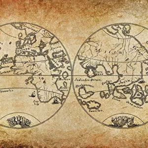
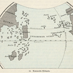
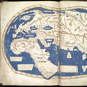
Poster Print : Paolo dal Pozzo Toscanelli map of earth from 15th century


![]()
Poster Prints from Fine Art Storehouse
Paolo dal Pozzo Toscanelli map of earth from 15th century
Illustration of a Paolo dal Pozzo Toscanelli map of earth from 15th century
Unleash your creativity and transform your space into a visual masterpiece!
Nastasic
Media ID 14719397
© This content is subject to copyright
18x24 inch Poster Print
Discover the fascinating history of cartography with our exquisite Paolo dal Pozzo Toscanelli Map of the Earth from the 15th century, available now at Media Storehouse from the Fine Art Storehouse collection. This breathtaking reproduction showcases the intricate detail and captivating accuracy of one of the earliest known world maps, meticulously crafted by the renowned Italian scholar and cartographer, Paolo dal Pozzo Toscanelli. Immerse yourself in the rich tapestry of geographical exploration and intellectual curiosity as you display this magnificent piece in your home or office. The vibrant colors and meticulous detailing bring the map to life, transporting you back in time to an era of groundbreaking discoveries and new horizons. Add this stunning work of art to your collection and embark on a journey through history.
Poster prints are budget friendly enlarged prints in standard poster paper sizes. Printed on 150 gsm Matte Paper for a natural feel and supplied rolled in a tube. Great for framing and should last many years. To clean wipe with a microfiber, non-abrasive cloth or napkin. Our Archival Quality Photo Prints and Fine Art Paper Prints are printed on higher quality paper and the choice of which largely depends on your budget.
Poster prints are budget friendly enlarged prints in standard poster paper sizes (A0, A1, A2, A3 etc). Whilst poster paper is sometimes thinner and less durable than our other paper types, they are still ok for framing and should last many years. Our Archival Quality Photo Prints and Fine Art Paper Prints are printed on higher quality paper and the choice of which largely depends on your budget.
Estimated Product Size is 61.6cm x 46.3cm (24.3" x 18.2")
These are individually made so all sizes are approximate
Artwork printed orientated as per the preview above, with landscape (horizontal) orientation to match the source image.
FEATURES IN THESE COLLECTIONS
> Maps and Charts
> Related Images
EDITORS COMMENTS
This print showcases an exquisite illustration of the Paolo dal Pozzo Toscanelli map of the Earth from the 15th century. A true masterpiece, this artwork by Nastasic takes us on a journey back in time to explore the intricate cartographic knowledge of one of history's greatest minds. Paolo dal Pozzo Toscanelli, a renowned Italian mathematician and astronomer, meticulously crafted this map during an era when geographical understanding was still evolving. The level of detail and precision depicted in his work is awe-inspiring, considering the limited resources available at that time. As we gaze upon this remarkable piece, we are transported to a world where exploration and discovery were paramount. The map reveals continents with their familiar shapes but also hints at uncharted territories waiting to be explored. It serves as a testament to human curiosity and our innate desire to understand our place in the vastness of space. Nastasic's photograph beautifully captures every intricate line and delicate brushstroke, allowing us to appreciate not only Toscanelli's genius but also the artistry involved in preserving such historical treasures. This print is more than just an image; it represents centuries of scientific progress and intellectual pursuit. Whether you are a history enthusiast or simply captivated by ancient cartography, this Paolo dal Pozzo Toscanelli map print will undoubtedly transport you back in time while igniting your imagination for what lies beyond our known horizons.
MADE IN THE USA
Safe Shipping with 30 Day Money Back Guarantee
FREE PERSONALISATION*
We are proud to offer a range of customisation features including Personalised Captions, Color Filters and Picture Zoom Tools
SECURE PAYMENTS
We happily accept a wide range of payment options so you can pay for the things you need in the way that is most convenient for you
* Options may vary by product and licensing agreement. Zoomed Pictures can be adjusted in the Cart.