Poster Print > North America > Barbados > Maps
Poster Print : Barbados country map


Please select a smaller print size for this image
![]()
from Fine Art Storehouse
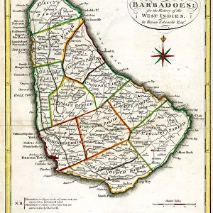
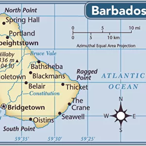
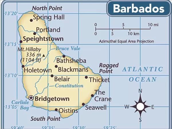
Barbados country map
2011 edition
Unleash your creativity and transform your space into a visual masterpiece!
Media ID 14432425
18x24 inch Poster Print
Poster prints are budget friendly enlarged prints in standard poster paper sizes. Printed on 150 gsm Matte Paper for a natural feel and supplied rolled in a tube. Great for framing and should last many years. To clean wipe with a microfiber, non-abrasive cloth or napkin. Our Archival Quality Photo Prints and Fine Art Paper Prints are printed on higher quality paper and the choice of which largely depends on your budget.
Poster prints are budget friendly enlarged prints in standard poster paper sizes (A0, A1, A2, A3 etc). Whilst poster paper is sometimes thinner and less durable than our other paper types, they are still ok for framing and should last many years. Our Archival Quality Photo Prints and Fine Art Paper Prints are printed on higher quality paper and the choice of which largely depends on your budget.
Estimated Product Size is 61.6cm x 46.3cm (24.3" x 18.2")
These are individually made so all sizes are approximate
Artwork printed orientated as per the preview above, with landscape (horizontal) orientation to match the source image.
FEATURES IN THESE COLLECTIONS
> Fine Art Storehouse
> Map
> Reference Maps
> Maps and Charts
> Related Images
> North America
> Barbados
> Maps
> North America
> Barbados
> Related Images
EDITORS COMMENTS
This print showcases the intricate details of a Barbados country map, specifically the 2011 edition. With its vibrant colors and precise cartographic features, this artwork from Fine Art Storehouse transports viewers to the enchanting Caribbean island. The map captures the essence of Barbados, displaying its stunning coastline with pristine beaches that stretch along turquoise waters. As one's gaze moves inland, lush greenery dominates the landscape, depicting dense tropical forests and rolling hills that invite exploration. Every town and village is meticulously labeled on this map, allowing viewers to immerse themselves in the rich cultural heritage of Barbados. From Bridgetown's bustling streets to Oistins' lively fish market, each location holds its own unique charm waiting to be discovered. Beyond geographical accuracy lies an artistic touch within this print. The delicate brushstrokes used by Fine Art Storehouse evoke a sense of tranquility as they blend seamlessly into each other. This technique adds depth and dimensionality to an already visually striking piece. Whether you are an avid traveler or simply appreciate fine artistry, this print serves as both a decorative statement and a source of inspiration for wanderlust-filled dreams. It invites you to embark on a mental journey through Barbados' picturesque landscapes while igniting curiosity about what lies beyond those borders. Note
MADE IN THE USA
Safe Shipping with 30 Day Money Back Guarantee
FREE PERSONALISATION*
We are proud to offer a range of customisation features including Personalised Captions, Color Filters and Picture Zoom Tools
SECURE PAYMENTS
We happily accept a wide range of payment options so you can pay for the things you need in the way that is most convenient for you
* Options may vary by product and licensing agreement. Zoomed Pictures can be adjusted in the Cart.