Poster Print > Popular Themes > Politics
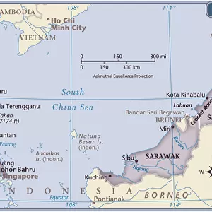
Poster Print : Political map of South East Asia


![]()
Poster Prints from Fine Art Storehouse
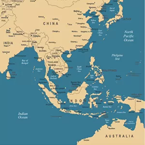
Political map of South East Asia
Vector illustration of the political map of South East Asia
Reference map was created by the US Central Intelligence Agency and is available as a public domain map at the University of Texas Libraries website
Unleash your creativity and transform your space into a visual masterpiece!
Media ID 15192872
27x27 inch Poster Print
Introducing the Political Map of South East Asia print from Media Storehouse's Fine Art collection. This captivating poster showcases an intricately detailed vector illustration of the political map of South East Asia, meticulously created by the US Central Intelligence Agency. Bring a touch of geographical sophistication to your space with this visually striking and informative piece. Ideal for educators, world travelers, and anyone with a passion for geography and politics, this poster is not only a beautiful addition to your home or office, but also a great conversation starter. Order now and explore the diverse regions of South East Asia in a whole new light.
Poster prints are budget friendly enlarged prints in standard poster paper sizes. Printed on 150 gsm Matte Paper for a natural feel and supplied rolled in a tube. Great for framing and should last many years. To clean wipe with a microfiber, non-abrasive cloth or napkin. Our Archival Quality Photo Prints and Fine Art Paper Prints are printed on higher quality paper and the choice of which largely depends on your budget.
Poster prints are budget friendly enlarged prints in standard poster paper sizes (A0, A1, A2, A3 etc). Whilst poster paper is sometimes thinner and less durable than our other paper types, they are still ok for framing and should last many years. Our Archival Quality Photo Prints and Fine Art Paper Prints are printed on higher quality paper and the choice of which largely depends on your budget.
Estimated Product Size is 69.2cm x 69.2cm (27.2" x 27.2")
These are individually made so all sizes are approximate
Artwork printed orientated as per the preview above, with landscape (horizontal) or portrait (vertical) orientation to match the source image.
FEATURES IN THESE COLLECTIONS
> Fine Art Storehouse
> Map
> Reference Maps
> Asia
> Related Images
> Maps and Charts
> Related Images
EDITORS COMMENTS
This print showcases a meticulously detailed political map of South East Asia, rendered in stunning vector illustration. Every intricate border and geographical feature is expertly depicted, offering an immersive visual experience for any admirer of cartography. The reference map used as the basis for this artwork was originally created by the US Central Intelligence Agency and is now available as a public domain resource at the esteemed University of Texas Libraries website. This ensures its accuracy and reliability, making it an invaluable tool for scholars, researchers, or anyone with a keen interest in exploring the diverse nations that comprise this vibrant region. From Indonesia's sprawling archipelago to Vietnam's elongated coastline; from Thailand's lush jungles to Malaysia's modern metropolises - all are beautifully represented on this print. The delicate balance between land and sea is artfully captured, showcasing not only national boundaries but also major rivers, mountain ranges, and other natural landmarks that shape these countries' identities. Whether displayed in a classroom setting or proudly hung on your own wall at home, this print serves as both an educational resource and a striking piece of art. It invites viewers to embark on their own mental journey through South East Asia - unraveling its rich history, cultural diversity, and geopolitical dynamics one glance at a time.
MADE IN THE USA
Safe Shipping with 30 Day Money Back Guarantee
FREE PERSONALISATION*
We are proud to offer a range of customisation features including Personalised Captions, Color Filters and Picture Zoom Tools
SECURE PAYMENTS
We happily accept a wide range of payment options so you can pay for the things you need in the way that is most convenient for you
* Options may vary by product and licensing agreement. Zoomed Pictures can be adjusted in the Cart.