Poster Print > Fine Art Storehouse > Map > Reference Maps
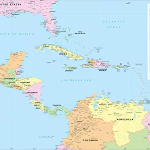
Poster Print : United States reference map


Please select a smaller print size for this image
![]()
Poster Prints from Fine Art Storehouse
United States reference map
Fine Art Storehouse Maps: Reference Maps
Unleash your creativity and transform your space into a visual masterpiece!
Media ID 14431161
12x16 inch Poster Print
Explore the intricacies of the United States with our exquisite Reference Map Poster Print from Fine Art Storehouse. This detailed and beautifully designed map is part of our Media Storehouse collection of high-quality poster prints. Ideal for educators, historians, or anyone with a passion for geography, this map is a stunning addition to any room. With its vibrant colors and meticulous attention to detail, this poster print is not only functional but also a work of art. Bring the wonders of cartography into your home or office today.
Poster prints are budget friendly enlarged prints in standard poster paper sizes. Printed on 150 gsm Matte Paper for a natural feel and supplied rolled in a tube. Great for framing and should last many years. To clean wipe with a microfiber, non-abrasive cloth or napkin. Our Archival Quality Photo Prints and Fine Art Paper Prints are printed on higher quality paper and the choice of which largely depends on your budget.
Poster prints are budget friendly enlarged prints in standard poster paper sizes (A0, A1, A2, A3 etc). Whilst poster paper is sometimes thinner and less durable than our other paper types, they are still ok for framing and should last many years. Our Archival Quality Photo Prints and Fine Art Paper Prints are printed on higher quality paper and the choice of which largely depends on your budget.
Estimated Product Size is 31.1cm x 41.3cm (12.2" x 16.3")
These are individually made so all sizes are approximate
Artwork printed orientated as per the preview above, with landscape (horizontal) or portrait (vertical) orientation to match the source image.
EDITORS COMMENTS
This print showcases a meticulously detailed United States reference map, brought to you by Fine Art Storehouse Maps: Reference Maps. With its intricate cartography and rich colors, this artwork is a testament to the beauty and complexity of our great nation. Every state is clearly delineated, allowing viewers to explore the vast diversity that makes up the United States. From the rugged mountains of the West Coast to the sprawling plains of the Midwest, this map captures it all with stunning accuracy. The rivers, lakes, and coastlines are intricately depicted, highlighting their importance in shaping both geography and history. The attention to detail in this print is truly remarkable; even small towns and major cities are labeled for easy navigation. Whether you're planning a road trip or simply curious about different regions within America's borders, this reference map provides an invaluable resource for exploration. Perfectly suited for any home or office space, this art piece adds sophistication and educational value to any setting. Its timeless appeal transcends generations as it invites viewers on a visual journey across one of Earth's most diverse countries.
MADE IN THE USA
Safe Shipping with 30 Day Money Back Guarantee
FREE PERSONALISATION*
We are proud to offer a range of customisation features including Personalised Captions, Color Filters and Picture Zoom Tools
SECURE PAYMENTS
We happily accept a wide range of payment options so you can pay for the things you need in the way that is most convenient for you
* Options may vary by product and licensing agreement. Zoomed Pictures can be adjusted in the Cart.