Poster Print > Arts > Street art graffiti > Digital art > Vector illustrations
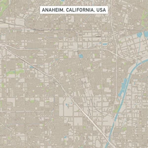
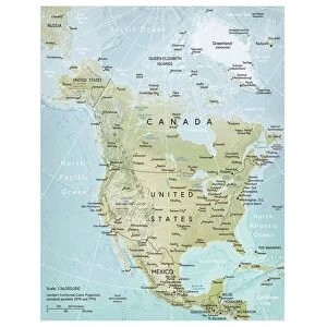
Poster Print : West Covina California US City Street Map


![]()
Poster Prints from Fine Art Storehouse
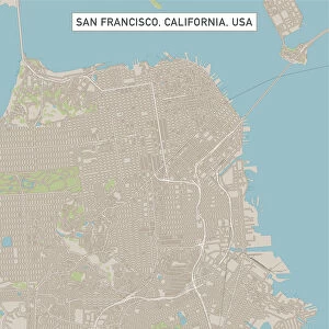
West Covina California US City Street Map
Vector Illustration of a City Street Map of West Covina, California, USA. Scale 1:60, 000.
All source data is in the public domain.
U.S. Geological Survey, US Topo
Used Layers:
USGS The National Map: National Hydrography Dataset (NHD)
USGS The National Map: National Transportation Dataset (NTD)
Unleash your creativity and transform your space into a visual masterpiece!
Frank Ramspott
Media ID 15055049
© Frank Ramspott, all rights reserved
Aerial View California City Map Computer Graphic Directly Above Downtown District Gray Road Map Text Digitally Generated Image Green Color White Color
27x27 inch Poster Print
Discover the charm of West Covina, California with our stunningly detailed City Street Map print from Frank Ramspott's Media Storehouse collection. This captivating vector illustration offers a precise 1:60,000 scale representation of the city's streets, making it an essential addition for both locals and visitors. With all source data sourced from the public domain and the United States, this beautiful Fine Art Storehouse print is not only a functional tool but also a decorative piece that adds character to any room. Bring a piece of West Covina into your home or office today!
Poster prints are budget friendly enlarged prints in standard poster paper sizes. Printed on 150 gsm Matte Paper for a natural feel and supplied rolled in a tube. Great for framing and should last many years. To clean wipe with a microfiber, non-abrasive cloth or napkin. Our Archival Quality Photo Prints and Fine Art Paper Prints are printed on higher quality paper and the choice of which largely depends on your budget.
Poster prints are budget friendly enlarged prints in standard poster paper sizes (A0, A1, A2, A3 etc). Whilst poster paper is sometimes thinner and less durable than our other paper types, they are still ok for framing and should last many years. Our Archival Quality Photo Prints and Fine Art Paper Prints are printed on higher quality paper and the choice of which largely depends on your budget.
Estimated Product Size is 69.2cm x 69.2cm (27.2" x 27.2")
These are individually made so all sizes are approximate
Artwork printed orientated as per the preview above, with landscape (horizontal) or portrait (vertical) orientation to match the source image.
FEATURES IN THESE COLLECTIONS
> Fine Art Storehouse
> Map
> Street Maps
> Fine Art Storehouse
> Map
> USA Maps
> Aerial Photography
> Related Images
> Animals
> Insects
> Hemiptera
> Green Scale
> Animals
> Mammals
> Cricetidae
> California Mouse
> Arts
> Contemporary art
> Digital artwork
> Street art
> Arts
> Landscape paintings
> Waterfall and river artworks
> River artworks
> Arts
> Portraits
> Pop art gallery
> Street art portraits
> Arts
> Street art graffiti
> Digital art
> Digital paintings
> Arts
> Street art graffiti
> Digital art
> Vector illustrations
> Maps and Charts
> Geological Map
> Maps and Charts
> Related Images
EDITORS COMMENTS
This print showcases the intricate details of West Covina, California's city street map. With a scale of 1:60,000, every road and district is meticulously illustrated in this vector illustration. The image captures the essence of this vibrant city, highlighting its downtown district, river, lake, and bustling streets. The source data used to create this masterpiece is in the public domain and comes from reputable sources such as the U. S. Geological Survey (USGS) and their National Map datasets including the National Hydrography Dataset (NHD) and National Transportation Dataset (NTD). These layers ensure accuracy and authenticity in depicting West Covina's geography. Designed by Frank Ramspott using computer graphics technology, this digitally generated image offers an aerial view directly above the city. The color palette features shades of gray for roads and text while green represents parks or open spaces. Blue signifies water bodies like rivers or lakes while white denotes residential areas or commercial zones. With no people present in the picture, all attention is drawn towards exploring West Covina's layout and cartography. This stunning print serves as both a decorative piece for any space as well as a valuable tool for navigating through one of California's dynamic cities.
MADE IN THE USA
Safe Shipping with 30 Day Money Back Guarantee
FREE PERSONALISATION*
We are proud to offer a range of customisation features including Personalised Captions, Color Filters and Picture Zoom Tools
SECURE PAYMENTS
We happily accept a wide range of payment options so you can pay for the things you need in the way that is most convenient for you
* Options may vary by product and licensing agreement. Zoomed Pictures can be adjusted in the Cart.