Poster Print > Animals > Mammals > Cricetidae > California Mouse
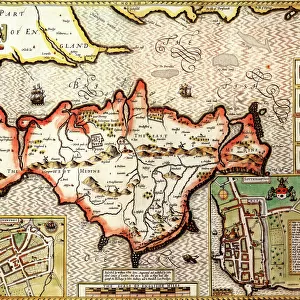
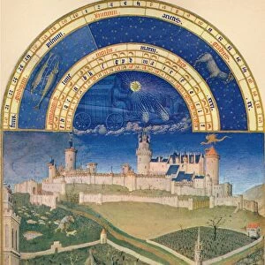
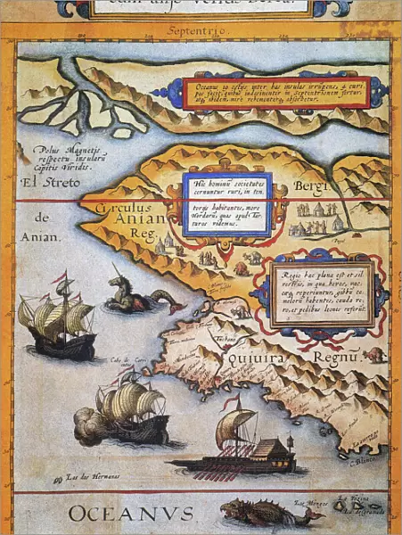
Poster Print : BERING STRAIT MAP, 1593. Cornelis de Jodes 1593 map of Western North America showing the fabled province of Quivira in California and the Bering Strait (El Streto de Anian); depicted also are two sea monsters, two European sailing ships, and a large Oriental
; depicted also are two sea monsters, two European sailing ships, and a large Oriental")

![]()
Poster Prints from Granger
BERING STRAIT MAP, 1593. Cornelis de Jodes 1593 map of Western North America showing the fabled province of Quivira in California and the Bering Strait (El Streto de Anian); depicted also are two sea monsters, two European sailing ships, and a large Oriental
BERING STRAIT MAP, 1593. Cornelis de Jodes 1593 map of Western North America showing the fabled province of Quivira in California and the Bering Strait (El Streto de Anian); depicted also are two sea monsters, two European sailing ships, and a large Oriental sailing galley
Granger holds millions of images spanning more than 25,000 years of world history, from before the Stone Age to the dawn of the Space Age
Media ID 6617543
1590s Age Of Discovery Alaska California Cornelis New World Ocean Province Russia Russian Sea Serpent Strait Topography Bering Strait Jode Quivira
18x24 inch Poster Print
Discover the captivating history of exploration with our Bering Strait Map print from The Granger Collection. Dated back to 1593, this rare and intriguing map by Cornelis de Jodes reveals the early European understanding of Western North America. This vintage map features the fabled province of Quivira in California, the legendary Bering Strait (El Streto de Anian), and other unexplored territories. The map also showcases two sea monsters, adding an element of mystery and intrigue. Two European sailing ships and a large Oriental vessel are depicted, highlighting the global reach of 16th-century exploration. Add this captivating Bering Strait Map print to your collection and bring the rich history of cartography into your home or office. This high-quality poster print is a perfect conversation starter and a unique addition to any room. Order yours today and step back in time to the age of discovery.
Poster prints are budget friendly enlarged prints in standard poster paper sizes. Printed on 150 gsm Matte Paper for a natural feel and supplied rolled in a tube. Great for framing and should last many years. To clean wipe with a microfiber, non-abrasive cloth or napkin. Our Archival Quality Photo Prints and Fine Art Paper Prints are printed on higher quality paper and the choice of which largely depends on your budget.
Poster prints are budget friendly enlarged prints in standard poster paper sizes (A0, A1, A2, A3 etc). Whilst poster paper is sometimes thinner and less durable than our other paper types, they are still ok for framing and should last many years. Our Archival Quality Photo Prints and Fine Art Paper Prints are printed on higher quality paper and the choice of which largely depends on your budget.
Estimated Product Size is 46.3cm x 61.6cm (18.2" x 24.3")
These are individually made so all sizes are approximate
Artwork printed orientated as per the preview above, with portrait (vertical) orientation to match the source image.
FEATURES IN THESE COLLECTIONS
> Granger Art on Demand
> Maps
> Granger Art on Demand
> Mythology
> Animals
> Mammals
> Cricetidae
> California Mouse
> Animals
> Mammals
> Muridae
> Western Mouse
> Arts
> Artists
> O
> Oceanic Oceanic
> Arts
> Landscape paintings
> Waterfall and river artworks
> River artworks
> Europe
> Related Images
> Europe
> Russia
> Related Images
EDITORS COMMENTS
This print showcases the Bering Strait Map of 1593, created by Cornelis de Jode. The map provides a fascinating glimpse into Western North America during the Age of Discovery. It vividly depicts the mythical province of Quivira in California and highlights the significant Bering Strait, also known as El Streto de Anian. The intricately detailed artwork features two awe-inspiring sea monsters lurking in the vast ocean waters, adding an element of mystery and adventure to this historical representation. Additionally, two European sailing ships gracefully navigate through these uncharted territories alongside a grand Oriental sailing galley. As we delve into this remarkable piece, it becomes evident that it is not merely a geographical depiction but rather a testament to human curiosity and exploration. The map serves as a visual record of early attempts to understand and conquer new lands. Notably, the inclusion of Quivira alludes to legends surrounding seven cities of gold that captivated explorers' imaginations at that time. This detail further emphasizes how maps were often influenced by folklore and tales from distant lands. Overall, this exquisite print offers viewers an opportunity to travel back in time and witness the evolving understanding of Western North America's topography during one of history's most exciting periods – an era when intrepid explorers set sail towards unknown horizons in search of discovery and riches beyond their wildest dreams.
MADE IN THE USA
Safe Shipping with 30 Day Money Back Guarantee
FREE PERSONALISATION*
We are proud to offer a range of customisation features including Personalised Captions, Color Filters and Picture Zoom Tools
SECURE PAYMENTS
We happily accept a wide range of payment options so you can pay for the things you need in the way that is most convenient for you
* Options may vary by product and licensing agreement. Zoomed Pictures can be adjusted in the Cart.