Poster Print > Oceania > New Zealand > Maps
Poster Print : Ports d'Auckland; Les Terres Du Pacifique, 1914. Creator: Unknown


![]()
Poster Prints from Heritage Images
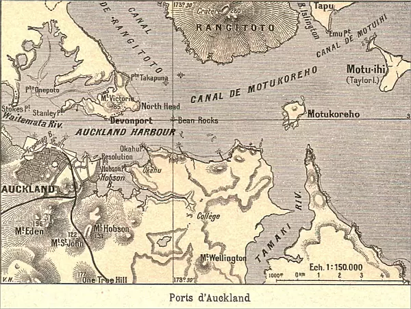
Ports d'Auckland; Les Terres Du Pacifique, 1914. Creator: Unknown
Ports d'Auckland; Les Terres Du Pacifique, 1914. From "Grande Geographie Bong Illustree", 1914
Heritage Images features heritage image collections
Media ID 36287498
© The Print Collector/Heritage Images
Aotearoa Australasia Cartography Geological Map Map Making Mapmaking New Zealand Auckland Harbour
18x24 inch Poster Print
Step back in time with our exquisite selection of vintage poster prints from Media Storehouse. This captivating piece, titled "Ports d'Auckland; Les Terres Du Pacifique" from the year 1914, showcases the bustling ports of Auckland, New Zealand. Originally published in the renowned Grande Geographie Bong Illustree, this stunning, unknown creation transports you to a bygone era with its intricate details and rich colors. Bring a piece of history into your home or office with this beautiful, unknown work from Heritage Images.
Poster prints are budget friendly enlarged prints in standard poster paper sizes. Printed on 150 gsm Matte Paper for a natural feel and supplied rolled in a tube. Great for framing and should last many years. To clean wipe with a microfiber, non-abrasive cloth or napkin. Our Archival Quality Photo Prints and Fine Art Paper Prints are printed on higher quality paper and the choice of which largely depends on your budget.
Poster prints are budget friendly enlarged prints in standard poster paper sizes (A0, A1, A2, A3 etc). Whilst poster paper is sometimes thinner and less durable than our other paper types, they are still ok for framing and should last many years. Our Archival Quality Photo Prints and Fine Art Paper Prints are printed on higher quality paper and the choice of which largely depends on your budget.
Estimated Product Size is 61.6cm x 46.3cm (24.3" x 18.2")
These are individually made so all sizes are approximate
Artwork printed orientated as per the preview above, with landscape (horizontal) orientation to match the source image.
FEATURES IN THESE COLLECTIONS
> Maps and Charts
> Geological Map
> Maps and Charts
> Related Images
> Oceania
> New Zealand
> Auckland
> Oceania
> New Zealand
> Maps
> Oceania
> New Zealand
> Related Images
Ports d'Auckland; Les Terres Du Pacifique, 1914
EDITORS COMMENTS
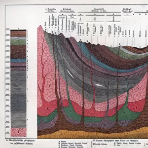
is a captivating and intriguing geographical map print from the early 20th century, created by an unknown cartographer. This vintage map offers a fascinating glimpse into the geographical knowledge and perception of the Pacific region during this time. The map focuses on the Auckland Harbour area in New Zealand, a significant location in the Pacific, and is part of a larger series published in the renowned French geographical publication "Grande Geographie Illustreé" in 1914. The map's title, "Ports d'Auckland; Les Terres Du Pacifique," translates to "Auckland Harbours; The Lands of the Pacific," indicating the map's primary focus on this region. The map is a testament to the advancements in cartography during the 1900s. It is a colorful and detailed representation of the geographical features of the area, including the coastline, islands, and harbors. The map also includes a geological map insert, which provides information on the geological formations and structures beneath the surface. The map's vibrant colors and intricate detailing transport us back in time, offering a unique perspective on how the Pacific region was perceived and represented during the early 20th century. The map's unknown origin adds to its allure and mystery, making it a valuable addition to any collection of historical maps or geographical curiosities. This map is not only a testament to the advancements in cartography during the 20th century but also a reminder of the rich history and cultural significance of the Pacific region. It serves as a reminder of the importance of exploration, discovery, and the pursuit of knowledge, making it a must-have for anyone with an interest in geography, history, or the Pacific region.
MADE IN THE USA
Safe Shipping with 30 Day Money Back Guarantee
FREE PERSONALISATION*
We are proud to offer a range of customisation features including Personalised Captions, Color Filters and Picture Zoom Tools
SECURE PAYMENTS
We happily accept a wide range of payment options so you can pay for the things you need in the way that is most convenient for you
* Options may vary by product and licensing agreement. Zoomed Pictures can be adjusted in the Cart.