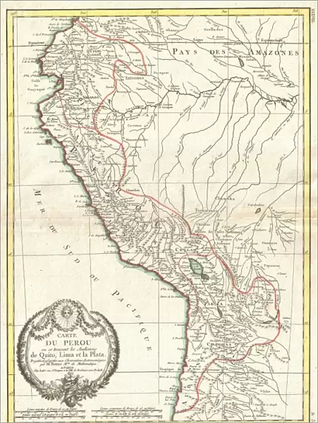
Poster Print : 1775, Bonne Map of Peru, Ecuador, Bolivia, and the Western Amazon, Rigobert Bonne 1727 - 1794


![]()
Poster Prints from Liszt Collection
1775, Bonne Map of Peru, Ecuador, Bolivia, and the Western Amazon, Rigobert Bonne 1727 - 1794
1775, Bonne Map of Peru, Ecuador, Bolivia, and the Western Amazon, Rigobert Bonne 1727 - 1794, one of the most important cartographers of the late 18th century
Liszt Collection of nineteenth-century engravings and images to browse and enjoy
Media ID 14004731
© Artokoloro Quint Lox Limited
1775 Bolivia Ecuador Rigobert Bonne 1727 1794 Rigobert Bonne 1727 – 1794 Rigobert Bonne 17271794 Antique Map Latitude Longitude Mappa Mundi Old Antique Plan Old Antique View Ols Antique Map Rare Old Maps Topo
18x24 inch Poster Print
Step back in time with our exquisite selection from the Media Storehouse range of Poster Prints. This captivating piece showcases the 1775 Bonne Map of Peru, Ecuador, Bolivia, and the Western Amazon, created by the renowned cartographer Rigobert Bonne (1727-1794). Known for his significant contributions to cartography during the late 18th century, Bonne's intricately detailed map transports you to a time of exploration and discovery. Add this beautiful and historically significant poster to your collection and adorn your walls with a piece of cartographic history.
Poster prints are budget friendly enlarged prints in standard poster paper sizes. Printed on 150 gsm Matte Paper for a natural feel and supplied rolled in a tube. Great for framing and should last many years. To clean wipe with a microfiber, non-abrasive cloth or napkin. Our Archival Quality Photo Prints and Fine Art Paper Prints are printed on higher quality paper and the choice of which largely depends on your budget.
Poster prints are budget friendly enlarged prints in standard poster paper sizes (A0, A1, A2, A3 etc). Whilst poster paper is sometimes thinner and less durable than our other paper types, they are still ok for framing and should last many years. Our Archival Quality Photo Prints and Fine Art Paper Prints are printed on higher quality paper and the choice of which largely depends on your budget.
Estimated Product Size is 46.3cm x 61.6cm (18.2" x 24.3")
These are individually made so all sizes are approximate
Artwork printed orientated as per the preview above, with portrait (vertical) orientation to match the source image.
EDITORS COMMENTS
This print showcases the remarkable "1775, Bonne Map of Peru, Ecuador, Bolivia, and the Western Amazon" created by Rigobert Bonne. As one of the most influential cartographers during the late 18th century, Bonne's expertise in topography and geography is evident in this intricate illustration. The map encompasses a vast expanse of land, providing an invaluable glimpse into the historical geography of Peru, Ecuador, Bolivia, and the Western Amazon. With its meticulously detailed grid lines indicating latitude and longitude coordinates, this vintage piece serves as a navigational tool for explorers and historians alike. The aged appearance adds to its charm as it transports us back to a time when cartography was both an art form and a scientific endeavor. Its decorative elements evoke a sense of wonder about our world's past exploration and discovery. As we gaze upon this rare antique map from Rigobert Bonne's collection dating back to 1775, we are reminded of how far we have come in understanding our planet's diverse regions. This extraordinary piece invites us on a journey through history while highlighting the importance of preserving these valuable artifacts for future generations.
MADE IN THE USA
Safe Shipping with 30 Day Money Back Guarantee
FREE PERSONALISATION*
We are proud to offer a range of customisation features including Personalised Captions, Color Filters and Picture Zoom Tools
SECURE PAYMENTS
We happily accept a wide range of payment options so you can pay for the things you need in the way that is most convenient for you
* Options may vary by product and licensing agreement. Zoomed Pictures can be adjusted in the Cart.