Poster Print : 1855, Colton Map of Peru and Bolivia, topography, cartography, geography, land, illustration


![]()
Poster Prints from Liszt Collection
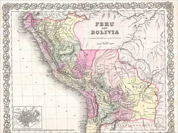
1855, Colton Map of Peru and Bolivia, topography, cartography, geography, land, illustration
1855, Colton Map of Peru and Bolivia
Liszt Collection of nineteenth-century engravings and images to browse and enjoy
Media ID 14007525
© Artokoloro Quint Lox Limited
1855 Antique Map Latitude Longitude Mappa Mundi Old Antique Plan Old Antique View Ols Antique Map Rare Old Maps Topo
18x24 inch Poster Print
Discover the rich history and geography of Peru and Bolivia with our stunning poster print from the Media Storehouse Liszt Collection. This intricately detailed 1855 Colton Map of Peru and Bolivia showcases the topography, cartography, and illustrations of the region during a pivotal time in its history. Bring the captivating world of South American geography into your home or office with this beautiful and informative poster print. Perfect for educators, history enthusiasts, or anyone with a curiosity for the wonders of the world.
Poster prints are budget friendly enlarged prints in standard poster paper sizes. Printed on 150 gsm Matte Paper for a natural feel and supplied rolled in a tube. Great for framing and should last many years. To clean wipe with a microfiber, non-abrasive cloth or napkin. Our Archival Quality Photo Prints and Fine Art Paper Prints are printed on higher quality paper and the choice of which largely depends on your budget.
Poster prints are budget friendly enlarged prints in standard poster paper sizes (A0, A1, A2, A3 etc). Whilst poster paper is sometimes thinner and less durable than our other paper types, they are still ok for framing and should last many years. Our Archival Quality Photo Prints and Fine Art Paper Prints are printed on higher quality paper and the choice of which largely depends on your budget.
Estimated Product Size is 61.6cm x 46.3cm (24.3" x 18.2")
These are individually made so all sizes are approximate
Artwork printed orientated as per the preview above, with landscape (horizontal) orientation to match the source image.
EDITORS COMMENTS
This print showcases the intricate and detailed 1855 Colton Map of Peru and Bolivia. A true masterpiece in the realm of cartography, this vintage map takes us on a journey through time, offering a glimpse into the topography, geography, and land formations of these South American countries. With its precise illustrations and meticulous attention to detail, this map serves as both an educational tool and a work of art. Its geometric grid system allows for easy navigation across latitude and longitude lines, making it an invaluable resource for travelers and explorers alike. The aged appearance adds a touch of historical charm to this decorative piece. It transports us back to an era when maps were meticulously hand-drawn with ink on paper, showcasing the craftsmanship that went into creating such intricate works. As we gaze upon this rare antique map from the Liszt Collection, we can't help but marvel at how it encapsulates not only geographical knowledge but also echoes of past discoveries and expeditions. It reminds us that our understanding of the world is ever-evolving and shaped by those who came before us. Whether you are a history enthusiast or simply appreciate fine artistry, this stunning print offers a window into another time—a testament to human curiosity about our planet's vast regions.
MADE IN THE USA
Safe Shipping with 30 Day Money Back Guarantee
FREE PERSONALISATION*
We are proud to offer a range of customisation features including Personalised Captions, Color Filters and Picture Zoom Tools
SECURE PAYMENTS
We happily accept a wide range of payment options so you can pay for the things you need in the way that is most convenient for you
* Options may vary by product and licensing agreement. Zoomed Pictures can be adjusted in the Cart.