Poster Print > Europe > France > Canton > Landes
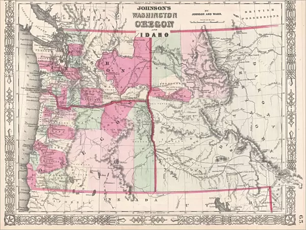
Poster Print : 1864, Johnson Map of Washington, Oregon, and Idaho, topography, cartography, geography


![]()
Poster Prints from Liszt Collection
1864, Johnson Map of Washington, Oregon, and Idaho, topography, cartography, geography
1864, Johnson Map of Washington, Oregon, and Idaho
Liszt Collection of nineteenth-century engravings and images to browse and enjoy
Media ID 14006032
© Artokoloro Quint Lox Limited
1864 Oregon Antique Map Johnson Map Of Washington Latitude Longitude Mappa Mundi Old Antique Plan Old Antique View Ols Antique Map Rare Old Maps Topo
18x24 inch Poster Print
Discover history with our stunning Media Storehouse Poster Prints, featuring the 1864 Johnson Map of Washington, Oregon, and Idaho from the Liszt Collection. This intricately detailed topographical map, published during a pivotal period in the exploration and settlement of the American West, showcases the cartography and geography of the region as it was understood at the time. Each print is produced using high-quality materials and vibrant colors to bring the intricacies of the map to life, making it an excellent addition to any home or office space. Journey back in time and explore the rich history of the Pacific Northwest with this beautiful and informative poster print.
Poster prints are budget friendly enlarged prints in standard poster paper sizes. Printed on 150 gsm Matte Paper for a natural feel and supplied rolled in a tube. Great for framing and should last many years. To clean wipe with a microfiber, non-abrasive cloth or napkin. Our Archival Quality Photo Prints and Fine Art Paper Prints are printed on higher quality paper and the choice of which largely depends on your budget.
Poster prints are budget friendly enlarged prints in standard poster paper sizes (A0, A1, A2, A3 etc). Whilst poster paper is sometimes thinner and less durable than our other paper types, they are still ok for framing and should last many years. Our Archival Quality Photo Prints and Fine Art Paper Prints are printed on higher quality paper and the choice of which largely depends on your budget.
Estimated Product Size is 61.6cm x 46.3cm (24.3" x 18.2")
These are individually made so all sizes are approximate
Artwork printed orientated as per the preview above, with landscape (horizontal) orientation to match the source image.
FEATURES IN THESE COLLECTIONS
> Europe
> France
> Canton
> Landes
> Historic
> Space exploration
> Maps and Charts
> Early Maps
> Maps and Charts
> Related Images
> Maps and Charts
> World
EDITORS COMMENTS
This print showcases the remarkable "1864, Johnson Map of Washington, Oregon, and Idaho". A true masterpiece in topography, cartography, and geography, this vintage map takes us on a journey through time. The intricate details beautifully illustrate the vastness and diversity of these three states. With its faded paper texture and aged appearance, this historic artifact transports us back to an era when exploration and discovery were at their peak. The carefully plotted grid lines reveal the precise latitude and longitude coordinates that guided early travelers across these uncharted lands. As we gaze upon this decorative piece of art, we can't help but marvel at the craftsmanship that went into creating such a comprehensive atlas. Every contour line represents a unique geographical feature; every stroke tells a story of our world's past. This rare old map is not just an antique relic; it serves as a reminder of how far we've come in understanding our planet's landscapes. It sparks curiosity about the regions depicted - what secrets lay hidden within those borders? What tales could be told by those who once traversed these territories? The "1864 Johnson Map" from Liszt Collection captures both history enthusiasts' hearts and admirers of fine art alike. Its presence invites us to embark on an imaginary voyage through time while appreciating the beauty found in ancient cartographic works like this one.
MADE IN THE USA
Safe Shipping with 30 Day Money Back Guarantee
FREE PERSONALISATION*
We are proud to offer a range of customisation features including Personalised Captions, Color Filters and Picture Zoom Tools
SECURE PAYMENTS
We happily accept a wide range of payment options so you can pay for the things you need in the way that is most convenient for you
* Options may vary by product and licensing agreement. Zoomed Pictures can be adjusted in the Cart.