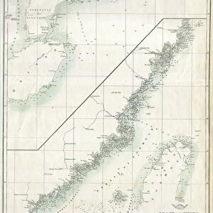
Poster Print : 1876, Imray Blue-back Nautical Chart or Map of Taiwan, Formosa, China, topography


![]()
Poster Prints from Liszt Collection
1876, Imray Blue-back Nautical Chart or Map of Taiwan, Formosa, China, topography
1876, Imray Blue-back Nautical Chart or Map of Taiwan, Formosa, China
Liszt Collection of nineteenth-century engravings and images to browse and enjoy
Media ID 14006382
© Artokoloro Quint Lox Limited
1876 China Formosa Antique Map Latitude Longitude Mappa Mundi Old Antique Plan Old Antique View Ols Antique Map Rare Old Maps Topo
18x24 inch Poster Print
Discover the rich history of maritime exploration with our stunning Media Storehouse Poster Print of the 1876 Imray Blue-back Nautical Chart or Map of Taiwan, Formosa, China, from the renowned Liszt Collection. This captivating vintage chart showcases intricate topographical details of the region, offering a glimpse into the past as well as a beautiful decorative piece for your home or office. With its authentic and detailed representation, this poster print is a must-have for history enthusiasts, cartography lovers, and anyone who appreciates the beauty of the world's cartographic heritage.
Poster prints are budget friendly enlarged prints in standard poster paper sizes. Printed on 150 gsm Matte Paper for a natural feel and supplied rolled in a tube. Great for framing and should last many years. To clean wipe with a microfiber, non-abrasive cloth or napkin. Our Archival Quality Photo Prints and Fine Art Paper Prints are printed on higher quality paper and the choice of which largely depends on your budget.
Poster prints are budget friendly enlarged prints in standard poster paper sizes (A0, A1, A2, A3 etc). Whilst poster paper is sometimes thinner and less durable than our other paper types, they are still ok for framing and should last many years. Our Archival Quality Photo Prints and Fine Art Paper Prints are printed on higher quality paper and the choice of which largely depends on your budget.
Estimated Product Size is 61.6cm x 46.3cm (24.3" x 18.2")
These are individually made so all sizes are approximate
Artwork printed orientated as per the preview above, with landscape (horizontal) orientation to match the source image.
EDITORS COMMENTS
This print showcases a remarkable piece of history - the 1876 Imray Blue-back Nautical Chart or Map of Taiwan, Formosa, China. With its intricate details and stunning topography, this map offers a glimpse into the past, allowing us to explore the geography and cartography of this region from over a century ago. The carefully illustrated landforms and geographic features on this vintage chart transport us back in time, inviting us to embark on a journey of discovery and exploration. The grid lines marking latitude and longitude add an element of precision to this artistic representation of Taiwan's landscape. As we gaze upon this ancient artifact, we are reminded of the importance that maps held in navigation during those times. This decorative piece not only serves as a historical document but also as an art form with its aged paper texture and retro aesthetic. With its rich colors and detailed illustrations, this old antique view takes us back to an era when maps were essential tools for travelers seeking new frontiers. It reminds us how far we have come in our understanding of the world while appreciating the beauty inherent in these rare old maps.
MADE IN THE USA
Safe Shipping with 30 Day Money Back Guarantee
FREE PERSONALISATION*
We are proud to offer a range of customisation features including Personalised Captions, Color Filters and Picture Zoom Tools
SECURE PAYMENTS
We happily accept a wide range of payment options so you can pay for the things you need in the way that is most convenient for you
* Options may vary by product and licensing agreement. Zoomed Pictures can be adjusted in the Cart.