Poster Print > Europe > United Kingdom > England > Birmingham > Area > Wells Green
Poster Print : Old Map of Birmingham 1866 by Fullarton & Co


![]()
Poster Prints from MapSeeker
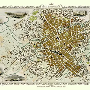
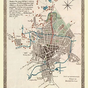
Old Map of Birmingham 1866 by Fullarton & Co
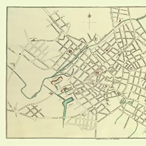
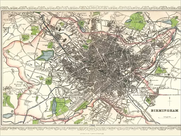
This detailed reproduction plan of Birmingham has been re-worked from an antique originally published in the 1860,s by Archibold Fullarton & Company. He was a well known publisher of books in the 19th century; however it is of significant note that the engraver, John Bartholomew Junior, had followed in the footsteps of his father and grandfather, establishing the reputation of the famous Bartholomew map-making company. John Bartholomew Junior was the first person to use layer colouring to indicate land heights and sea depths. The Bartholomew map-making generations would continue to prosper, introducing new map-making techniques into the 20th century. The plan of 1866 covers a greater area than previous plans of Birmingham, stretching out to include Aston, an area as yet not incorporated into Birmingham. To the south there is Edgbaston, the small village of Harborne is just about featured. However, this plan reveals something new, something that Birminghams people had needed for quite some time, public open space. The green coloured areas add a splash of colour to the plan, highlighting the arrival of BirminghamAEs first parks
Welcome to the Mapseeker Image library and enter an historic gateway to one of the largest on-line collections of Historic Maps, Nostalgic Views, Vista's and Panorama's from a World gone by.
Media ID 20347164
© Mapseeker Digital Ltd
Birmingham Birmingham City Birmingham City Map Birmingham Map Birmingham Town Plan City Of Birmingham Map Historic Birmingham Map Historic Map Map Of Birmingham Old Map Of Birmingham Old Town Plan Town Plan Of Birmingham
18x24 inch Poster Print
Step back in time with our Old Map of Birmingham 1866 by Fullarton & Co. Poster Print from Media Storehouse. This beautifully detailed reproduction brings history to life with its intricate depiction of Birmingham as it was over a century ago. Originally published by Archibold Fullarton & Company in the 1860s, this antique map showcases the city's growth and development during that era. Add a touch of historical charm to your home or office with this captivating piece of Birmingham's rich past.
Poster prints are budget friendly enlarged prints in standard poster paper sizes. Printed on 150 gsm Matte Paper for a natural feel and supplied rolled in a tube. Great for framing and should last many years. To clean wipe with a microfiber, non-abrasive cloth or napkin. Our Archival Quality Photo Prints and Fine Art Paper Prints are printed on higher quality paper and the choice of which largely depends on your budget.
Poster prints are budget friendly enlarged prints in standard poster paper sizes (A0, A1, A2, A3 etc). Whilst poster paper is sometimes thinner and less durable than our other paper types, they are still ok for framing and should last many years. Our Archival Quality Photo Prints and Fine Art Paper Prints are printed on higher quality paper and the choice of which largely depends on your budget.
Estimated Product Size is 61.6cm x 46.3cm (24.3" x 18.2")
These are individually made so all sizes are approximate
Artwork printed orientated as per the preview above, with landscape (horizontal) orientation to match the source image.
FEATURES IN THESE COLLECTIONS
> MapSeeker
> British Town And City Plans
> English & Welsh PORTFOLIO
> Arts
> Photorealistic artworks
> Detailed art pieces
> Masterful detailing in art
> Europe
> France
> Canton
> Landes
> Europe
> United Kingdom
> England
> Birmingham
> Area
> Aston
> Europe
> United Kingdom
> England
> Birmingham
> Area
> Edgbaston
> Europe
> United Kingdom
> England
> Birmingham
> Area
> Harborne
> Europe
> United Kingdom
> England
> Birmingham
> Area
> Wells Green
> Maps and Charts
> Related Images
EDITORS COMMENTS
This detailed reproduction print of the "Old Map of Birmingham 1866" by Fullarton & Co takes us back in time to a significant era in the city's history. Originally published in the 1860s, this antique map showcases the expertise and craftsmanship of Archibold Fullarton & Company, a renowned publisher during the 19th century. What makes this particular map even more remarkable is the contribution of John Bartholomew Junior, an engraver who followed in his father and grandfather's footsteps to establish the famous Bartholomew map-making company. John Bartholomew Junior introduced innovative techniques such as layer colouring to indicate land heights and sea depths, revolutionizing cartography at that time. Covering a larger area than previous plans, this 1866 edition includes Aston, which was not yet incorporated into Birmingham. It also features Edgbaston to the south and highlights Harborne village. However, what truly stands out on this plan are vibrant green-colored areas representing public open spaces – Birmingham's first parks. These splashes of color symbolize progress and reflect the growing need for recreational areas within an expanding industrial city like Birmingham. They offer respite from urban life while showcasing how society recognized its inhabitants' well-being even during times of rapid development. As we gaze upon this print, we can appreciate both its historical significance and its role in documenting Birmingham's evolution over time.
MADE IN THE USA
Safe Shipping with 30 Day Money Back Guarantee
FREE PERSONALISATION*
We are proud to offer a range of customisation features including Personalised Captions, Color Filters and Picture Zoom Tools
SECURE PAYMENTS
We happily accept a wide range of payment options so you can pay for the things you need in the way that is most convenient for you
* Options may vary by product and licensing agreement. Zoomed Pictures can be adjusted in the Cart.