Poster Print > Arts > Artists > M > Thomas Moule
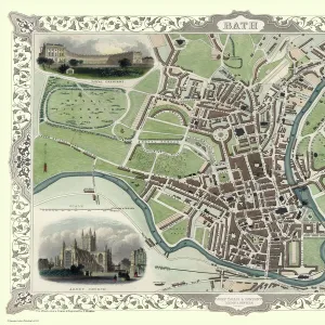
Poster Print : Old Map of the City of Bath 1836 by Thomas Moule


![]()
Poster Prints from MapSeeker
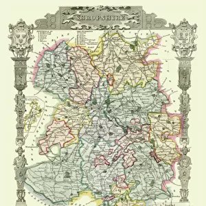
Old Map of the City of Bath 1836 by Thomas Moule
This is a fine decorative reproduction Map of The City of Bath from the First Edition series of Thomas Moule Maps, originally Published in 1836
Welcome to the Mapseeker Image library and enter an historic gateway to one of the largest on-line collections of Historic Maps, Nostalgic Views, Vista's and Panorama's from a World gone by.
Media ID 20348239
Historic Map Moule Map Old Town Plan Thomas Moule Thomas Moule Map Town Plan Bath City
18x24 inch Poster Print
Step back in time with our exquisite Old Map of the City of Bath 1836 by Thomas Moule from the esteemed MapSeeker collection. This fine decorative reproduction captures the historical charm of Bath, England, as it appeared over 180 years ago. The intricate details of the city's architecture and layout are beautifully preserved in this vintage map. Bring a touch of history and elegance to your home or office with this unique and captivating piece from the First Edition series of Thomas Moule Maps. Order now and travel through time with every glance.
Poster prints are budget friendly enlarged prints in standard poster paper sizes. Printed on 150 gsm Matte Paper for a natural feel and supplied rolled in a tube. Great for framing and should last many years. To clean wipe with a microfiber, non-abrasive cloth or napkin. Our Archival Quality Photo Prints and Fine Art Paper Prints are printed on higher quality paper and the choice of which largely depends on your budget.
Poster prints are budget friendly enlarged prints in standard poster paper sizes (A0, A1, A2, A3 etc). Whilst poster paper is sometimes thinner and less durable than our other paper types, they are still ok for framing and should last many years. Our Archival Quality Photo Prints and Fine Art Paper Prints are printed on higher quality paper and the choice of which largely depends on your budget.
Estimated Product Size is 46.3cm x 61.6cm (18.2" x 24.3")
These are individually made so all sizes are approximate
Artwork printed orientated as per the preview above, with portrait (vertical) orientation to match the source image.
FEATURES IN THESE COLLECTIONS
> MapSeeker
> British Town And City Plans
> English & Welsh PORTFOLIO
> Arts
> Artists
> M
> Thomas Moule
EDITORS COMMENTS
This stunning print showcases the "Old Map of the City of Bath 1836" by Thomas Moule, a renowned cartographer from the early 19th century. This fine decorative reproduction is part of the First Edition series of Thomas Moule Maps, originally published in 1836. The map offers a captivating glimpse into the historic city of Bath, capturing its intricate layout and architectural beauty during that era. With meticulous detail, it presents an invaluable resource for historians, urban planners, and enthusiasts alike. Thomas Moule's expertise shines through as he masterfully depicts every street, square, and landmark within this vibrant city. The town plan provides a fascinating insight into how Bath has evolved over time while retaining its timeless charm. This particular print serves as a testament to both Moule's skill as a cartographer and his passion for preserving history through maps. It allows us to appreciate Bath's rich heritage and invites us to explore its streets with our imagination. Whether you are an avid collector or simply captivated by historical maps, this print is sure to be a cherished addition to any space. Its elegant design and attention to detail make it an exquisite piece that celebrates not only Bath but also the artistry behind creating these remarkable historical documents.
MADE IN THE USA
Safe Shipping with 30 Day Money Back Guarantee
FREE PERSONALISATION*
We are proud to offer a range of customisation features including Personalised Captions, Color Filters and Picture Zoom Tools
SECURE PAYMENTS
We happily accept a wide range of payment options so you can pay for the things you need in the way that is most convenient for you
* Options may vary by product and licensing agreement. Zoomed Pictures can be adjusted in the Cart.