Poster Print > Europe > United Kingdom > Scotland > Perth and Kinross > Scone
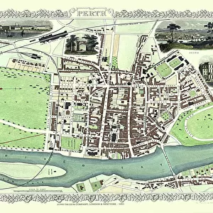
Poster Print : Old Map of Perth Scotland 1851 by John Tallis


![]()
Poster Prints from MapSeeker
Old Map of Perth Scotland 1851 by John Tallis
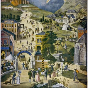
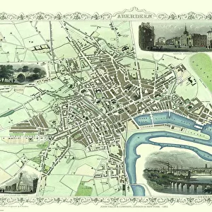
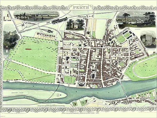
This 1851 John Tallis Victorian map of Perth in Scotland shows town sandwiched between the South Inch and North Inch. The plan shows only one bridge across the River Tay into Perth. The plan is finished with three attractive illustrations, Scone Palace, Kingfauns Castle and Bank of Scotland
Welcome to the Mapseeker Image library and enter an historic gateway to one of the largest on-line collections of Historic Maps, Nostalgic Views, Vista's and Panorama's from a World gone by.
Media ID 20347584
Historic Map John Tallis John Tallis Map Old Town Plan Tallis Map Perth
18x24 inch Poster Print
Introducing the Media Storehouse collection of vintage poster prints, featuring an intriguing old map of Perth, Scotland from 1851 by renowned cartographer John Tallis. This captivating map offers a glimpse into the past, showcasing Perth as it once was, nestled between the South Inch and North Inch, with only one bridge gracing the River Tay into the town. Travel back in time and adorn your walls with this exquisite piece of historical cartography. Perfect for history enthusiasts, map collectors, or those looking to add a touch of nostalgia to their decor. Order your vintage Perth map poster print today! #PerthHistory #JohnTallisMap #VintagePosterPrints #MapCollectors #HistoricalDecor
Poster prints are budget friendly enlarged prints in standard poster paper sizes. Printed on 150 gsm Matte Paper for a natural feel and supplied rolled in a tube. Great for framing and should last many years. To clean wipe with a microfiber, non-abrasive cloth or napkin. Our Archival Quality Photo Prints and Fine Art Paper Prints are printed on higher quality paper and the choice of which largely depends on your budget.
Poster prints are budget friendly enlarged prints in standard poster paper sizes (A0, A1, A2, A3 etc). Whilst poster paper is sometimes thinner and less durable than our other paper types, they are still ok for framing and should last many years. Our Archival Quality Photo Prints and Fine Art Paper Prints are printed on higher quality paper and the choice of which largely depends on your budget.
Estimated Product Size is 61.6cm x 46.3cm (24.3" x 18.2")
These are individually made so all sizes are approximate
Artwork printed orientated as per the preview above, with landscape (horizontal) orientation to match the source image.
FEATURES IN THESE COLLECTIONS
> MapSeeker
> British Town And City Plans
> Scottish PORTFOLIO
> Arts
> Artists
> T
> John Tallis
> Europe
> United Kingdom
> Scotland
> Castles
> Europe
> United Kingdom
> Scotland
> Maps
> Europe
> United Kingdom
> Scotland
> Palaces
> Europe
> United Kingdom
> Scotland
> Perth and Kinross
> Perth
> Europe
> United Kingdom
> Scotland
> Perth and Kinross
> Scone
> Europe
> United Kingdom
> Scotland
> Perth
> Europe
> United Kingdom
> Scotland
> Rivers
> Historic
> Medieval architecture
> Castles and fortresses
> Historic castles
> Maps and Charts
> Related Images
EDITORS COMMENTS
This 1851 John Tallis Victorian map of Perth, Scotland takes us on a journey back in time to explore the town's rich history. The intricately detailed plan showcases Perth nestled between the picturesque South Inch and North Inch, offering a glimpse into its geographical layout during that era. As we delve deeper into this historical artifact, our eyes are drawn to the sole bridge gracefully spanning across the majestic River Tay, connecting Perth with its surroundings. This single point of entry emphasizes the significance of this bustling town as a hub for trade and commerce. Adding an artistic touch to this remarkable map are three enchanting illustrations. The first depicts Scone Palace, an iconic landmark known for its regal charm and historic importance. Next is Kingfauns Castle, standing tall amidst lush greenery, evoking a sense of grandeur and mystery. Finally, we encounter the Bank of Scotland building—a symbol of financial stability and prosperity within Perth's thriving community. With every intricate detail meticulously preserved over centuries, this old map serves as a testament to both John Tallis' cartographic expertise and Perth's enduring legacy. It invites us to immerse ourselves in the past while appreciating how much has changed since then. Whether you're an avid historian or simply captivated by maps from yesteryears, this vintage print is sure to transport you through time as you unravel the stories woven within each street corner and architectural marvel captured on paper.
MADE IN THE USA
Safe Shipping with 30 Day Money Back Guarantee
FREE PERSONALISATION*
We are proud to offer a range of customisation features including Personalised Captions, Color Filters and Picture Zoom Tools
SECURE PAYMENTS
We happily accept a wide range of payment options so you can pay for the things you need in the way that is most convenient for you
* Options may vary by product and licensing agreement. Zoomed Pictures can be adjusted in the Cart.