Poster Print > Arts > Artists > T > John Tallis
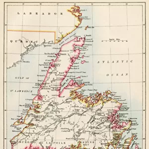
Poster Print : Old Map of East Canada and New Brunswick 1851 by John Tallis


![]()
Poster Prints from MapSeeker
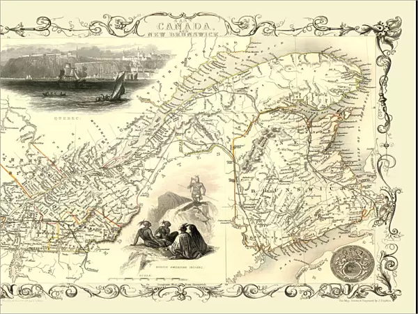
Old Map of East Canada and New Brunswick 1851 by John Tallis
A fine facimile artworked from an antique original map of East Canada and New Brunswick, issued as part of the 1851 edition of John Tallis and Companys " The Illustrated Atlas and Modern History of the World"
Welcome to the Mapseeker Image library and enter an historic gateway to one of the largest on-line collections of Historic Maps, Nostalgic Views, Vista's and Panorama's from a World gone by.
Media ID 20347660
© Mapseeker Publishing Ltd
John Tallis John Tallis Map Tallis Map
18x24 inch Poster Print
Step back in time with our Old Map of East Canada and New Brunswick 1851 by John Tallis. This stunning poster print is a faithful reproduction of the antique original map, taken from the 1851 edition of John Tallis and Company's "The Illustrated Atlas." Meticulously crafted by MapSeeker, this fine facsimile preserves the historical detail and charm of the original map, making it a captivating addition to any home or office. With its intricate cartography and rich, vivid colors, this poster print is not just a map, but a window into the past. Travel back to a time of exploration and discovery with this beautiful piece of cartographic history.
Poster prints are budget friendly enlarged prints in standard poster paper sizes. Printed on 150 gsm Matte Paper for a natural feel and supplied rolled in a tube. Great for framing and should last many years. To clean wipe with a microfiber, non-abrasive cloth or napkin. Our Archival Quality Photo Prints and Fine Art Paper Prints are printed on higher quality paper and the choice of which largely depends on your budget.
Poster prints are budget friendly enlarged prints in standard poster paper sizes (A0, A1, A2, A3 etc). Whilst poster paper is sometimes thinner and less durable than our other paper types, they are still ok for framing and should last many years. Our Archival Quality Photo Prints and Fine Art Paper Prints are printed on higher quality paper and the choice of which largely depends on your budget.
Estimated Product Size is 61.6cm x 46.3cm (24.3" x 18.2")
These are individually made so all sizes are approximate
Artwork printed orientated as per the preview above, with landscape (horizontal) orientation to match the source image.
FEATURES IN THESE COLLECTIONS
> MapSeeker
> Maps of the Americas
> Maps of Canada, Newfoundland
> Arts
> Artists
> T
> John Tallis
> Maps and Charts
> Related Images
> Maps and Charts
> World
> North America
> Canada
> Maps
> North America
> Canada
> Related Images
EDITORS COMMENTS
This print showcases an exquisite piece of history, the "Old Map of East Canada and New Brunswick 1851" by John Tallis. Crafted with utmost precision and attention to detail, this fine facsimile artwork is a testament to the rich cartographic heritage of Canada. Originally featured in the esteemed 1851 edition of John Tallis and Company's "The Illustrated Atlas and Modern History of the World" this map offers a glimpse into the past, transporting us back to a time when exploration was at its peak. With intricate illustrations depicting cities, rivers, mountains, and coastlines, it serves as a visual gateway to understanding how East Canada and New Brunswick appeared over 150 years ago. John Tallis's expertise shines through every stroke on this map. His dedication to accuracy allows us to trace historical routes taken by early settlers or discover forgotten landmarks that have shaped Canadian history. As we explore this vintage masterpiece, we can't help but marvel at its ability to connect us with our roots. Whether you are an avid historian or simply appreciate artistry from days gone by, this stunning print will undoubtedly captivate your imagination. Its timeless beauty makes it a perfect addition for any home or office space seeking an elegant touch infused with historical significance. Let yourself be transported back in time as you delve into the intricacies of this remarkable old map created by two visionary minds: John Tallis and John Rapkin.
MADE IN THE USA
Safe Shipping with 30 Day Money Back Guarantee
FREE PERSONALISATION*
We are proud to offer a range of customisation features including Personalised Captions, Color Filters and Picture Zoom Tools
SECURE PAYMENTS
We happily accept a wide range of payment options so you can pay for the things you need in the way that is most convenient for you
* Options may vary by product and licensing agreement. Zoomed Pictures can be adjusted in the Cart.