Poster Print > Europe > United Kingdom > Wales > South Glamorgan > Barry
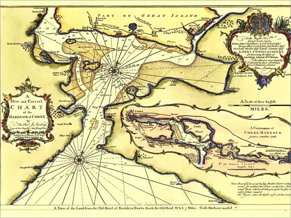
Poster Print : Early Coastal Survey Map of Chart of the Harbour of Cork 1759


![]()
Poster Prints from MapSeeker
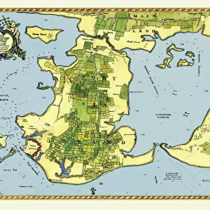
Early Coastal Survey Map of Chart of the Harbour of Cork 1759
This is a reproduction in colour of the early chart of Cork Harbour originally surveyed by John Lindsay, c.1759), and titled A New and Correct Chart of the Harbour of Corke by the Revd. J. Lindsay, Late of His Majestys Ship Fougueux. Sold by W. & I. Mount, T. & T. Page on Tower Hill, London. 1759, large dedication cartouche with name of Lords Commissioners, inset map of Cork harbour featuring detail of Little Island, Barrys Point, Black Rock, Glanmier, and approaches to the city - A Continuation of Corke Harbour from a smaller Scale, below the chart is a coastal profile - A View of the Land from the Old Head of Kinsale to Hawks Rock, the Old Head W bs 7 Miles
Welcome to the Mapseeker Image library and enter an historic gateway to one of the largest on-line collections of Historic Maps, Nostalgic Views, Vista's and Panorama's from a World gone by.
Media ID 20347483
18x24 inch Poster Print
"Step back in time with our stunning Media Storehouse Poster Print of the Early Coastal Survey Map of Cork Harbour, originally surveyed by John Lindsay in 1759. This beautiful reproduction in vibrant colours brings to life the intricate details of the harbour as it appeared over 250 years ago. Titled "A New and Correct Chart of the Harbour of Corke by the Revd. J. Rocque," this poster is more than just a decorative piece. It's a window into the past, offering a unique perspective on maritime history. Hang it in your home or office to add a touch of history and character to any space."
Poster prints are budget friendly enlarged prints in standard poster paper sizes. Printed on 150 gsm Matte Paper for a natural feel and supplied rolled in a tube. Great for framing and should last many years. To clean wipe with a microfiber, non-abrasive cloth or napkin. Our Archival Quality Photo Prints and Fine Art Paper Prints are printed on higher quality paper and the choice of which largely depends on your budget.
Poster prints are budget friendly enlarged prints in standard poster paper sizes (A0, A1, A2, A3 etc). Whilst poster paper is sometimes thinner and less durable than our other paper types, they are still ok for framing and should last many years. Our Archival Quality Photo Prints and Fine Art Paper Prints are printed on higher quality paper and the choice of which largely depends on your budget.
Estimated Product Size is 61.6cm x 46.3cm (24.3" x 18.2")
These are individually made so all sizes are approximate
Artwork printed orientated as per the preview above, with landscape (horizontal) orientation to match the source image.
FEATURES IN THESE COLLECTIONS
> MapSeeker
> Maps from the British Isles
> British Coastal Surveys PORTFOLIO
> Animals
> Insects
> Hemiptera
> Black Scale
> Arts
> Artists
> H
> John Hillers
> Arts
> Artists
> H
> John Hills
> Europe
> France
> Canton
> Landes
> Europe
> United Kingdom
> Wales
> South Glamorgan
> Barry
> Maps and Charts
> Early Maps
> Maps and Charts
> Related Images
EDITORS COMMENTS
This vibrant and meticulously detailed reproduction print showcases the Early Coastal Survey Map of Chart of the Harbour of Cork from 1759. Originally surveyed by John Lindsay, this chart was later revised and titled "A New and Correct Chart of the Harbour of Corke" by the Reverend J. Lindsay, who served on His Majesty's Ship Fougueux. The map is a true testament to the skill and dedication required for coastal surveying in that era. It features a large dedication cartouche with the names of Lords Commissioners, emphasizing its official status. An inset map provides a closer look at key areas within Cork Harbour, including Little Island, Barrys Point, Black Rock, Glanmier, and approaches to the city. What sets this print apart is its inclusion of additional elements that enhance our understanding of the region's geography. A continuation chart below offers further detail on Corke Harbour from a smaller scale perspective. Additionally, a coastal profile entitled "A View of Land from Old Head Kinsale to Hawks Rock" adds depth to our appreciation for this stretch along Ireland's southern coast. Whether you are an enthusiast or historian interested in British coastal surveys or simply captivated by maritime history, this stunning reproduction print will transport you back in time to experience firsthand how early charts were crafted with precision and artistry.
MADE IN THE USA
Safe Shipping with 30 Day Money Back Guarantee
FREE PERSONALISATION*
We are proud to offer a range of customisation features including Personalised Captions, Color Filters and Picture Zoom Tools
SECURE PAYMENTS
We happily accept a wide range of payment options so you can pay for the things you need in the way that is most convenient for you
* Options may vary by product and licensing agreement. Zoomed Pictures can be adjusted in the Cart.