Poster Print > Maps and Charts > World
Poster Print : Europe Map C1914


Poster Prints from Mary Evans Picture Library
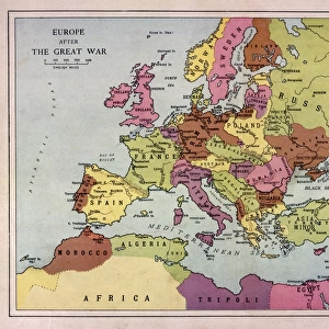
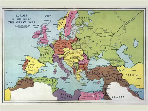
Europe Map C1914
The map of Europe on the eve of World War One
Mary Evans Picture Library makes available wonderful images created for people to enjoy over the centuries
Media ID 4315925
© Mary Evans Picture Library 2015 - https://copyrighthub.org/s0/hub1/creation/maryevans/MaryEvansPictureID/10125199
18x24 inch Poster Print
Introducing the captivating European Map C1914 from Media Storehouse's exclusive collection of historical poster prints. This intriguing piece, sourced from the extensive archive of Mary Evans Prints Online, offers a fascinating glimpse into Europe on the brink of World War One. The detailed cartography of this rights-managed map print transports you back in time, allowing you to explore the political landscape of Europe as it once was. Add an air of historical intrigue to your space with this evocative and engaging addition to your decor. Order your European Map C1914 poster print from Media Storehouse today and step into the past.
Poster prints are budget friendly enlarged prints in standard poster paper sizes. Printed on 150 gsm Matte Paper for a natural feel and supplied rolled in a tube. Great for framing and should last many years. To clean wipe with a microfiber, non-abrasive cloth or napkin. Our Archival Quality Photo Prints and Fine Art Paper Prints are printed on higher quality paper and the choice of which largely depends on your budget.
Poster prints are budget friendly enlarged prints in standard poster paper sizes (A0, A1, A2, A3 etc). Whilst poster paper is sometimes thinner and less durable than our other paper types, they are still ok for framing and should last many years. Our Archival Quality Photo Prints and Fine Art Paper Prints are printed on higher quality paper and the choice of which largely depends on your budget.
Estimated Image Size (if not cropped) is 61.5cm x 41.3cm (24.2" x 16.3")
Estimated Product Size is 61.6cm x 46.3cm (24.3" x 18.2")
These are individually made so all sizes are approximate
Artwork printed orientated as per the preview above, with landscape (horizontal) orientation to match the source image.
FEATURES IN THESE COLLECTIONS
> Europe
> Related Images
> Maps and Charts
> Early Maps
> Maps and Charts
> Popular Maps
> Maps and Charts
> Related Images
> Maps and Charts
> World
> Popular Themes
> Maps and Charts
EDITORS COMMENTS
This stunning print of the Europe Map circa 1914 captures a pivotal moment in history, just on the eve of World War One. The intricate details and borders of each country are beautifully depicted, showcasing the political landscape of Europe at that time. As we gaze upon this map, we can almost feel the tension and uncertainty that loomed over the continent before the outbreak of one of the deadliest conflicts in human history.
The colors and design of this map transport us back to a time when alliances were shifting, empires were crumbling, and nations were on edge. It serves as a powerful reminder of how quickly peace can unravel into chaos and conflict.
As we study this map closely, we can see how interconnected yet divided Europe was in 1914. Each country represented had its own ambitions, fears, and aspirations - all factors that would eventually contribute to the outbreak of World War One.
This print is not just a historical artifact; it is a visual representation of a world on the brink of destruction. It reminds us to never take peace for granted and to always strive for diplomacy over war.
MADE IN THE USA
Safe Shipping with 30 Day Money Back Guarantee
FREE PERSONALISATION*
We are proud to offer a range of customisation features including Personalised Captions, Color Filters and Picture Zoom Tools
SECURE PAYMENTS
We happily accept a wide range of payment options so you can pay for the things you need in the way that is most convenient for you
* Options may vary by product and licensing agreement. Zoomed Pictures can be adjusted in the Cart.