Poster Print > Europe > United Kingdom > Scotland > Fife > Falkland
Poster Print : Falklands War - 1982


![]()
Poster Prints from Mary Evans Picture Library
Falklands War - 1982
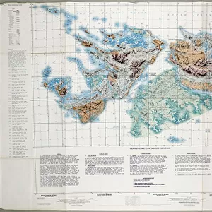
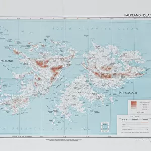
Directorate of Overseas Surveys map of the Falklands Islands, 1983 (c). One of four maps of the Falkland Islands, 1982 (c)-1984 (c). Associated with the South Atlantic (Falklands War), (1982) Date: circa 1860
Mary Evans Picture Library makes available wonderful images created for people to enjoy over the centuries
Media ID 14403821
© The National Army Museum / Mary Evans Picture Library
1982 1983 1984 Associated Atlantic Falkland Falklands Maps Overseas Surveying Surveys Directorate
18x24 inch Poster Print
Step back in time with our Falklands War - 1982 poster print from Media Storehouse. This captivating image, sourced from Mary Evans Prints Online, features a Directorate of Overseas Surveys map of the Falklands Islands from 1983. A fascinating historical record, this poster is perfect for history enthusiasts, educators, or anyone interested in the geopolitical events of the 1980s. Rights managed by Mary Evans, this high-quality print is a must-have addition to any home or office space. Order yours today and relive the history of the Falklands War.
Poster prints are budget friendly enlarged prints in standard poster paper sizes. Printed on 150 gsm Matte Paper for a natural feel and supplied rolled in a tube. Great for framing and should last many years. To clean wipe with a microfiber, non-abrasive cloth or napkin. Our Archival Quality Photo Prints and Fine Art Paper Prints are printed on higher quality paper and the choice of which largely depends on your budget.
Poster prints are budget friendly enlarged prints in standard poster paper sizes (A0, A1, A2, A3 etc). Whilst poster paper is sometimes thinner and less durable than our other paper types, they are still ok for framing and should last many years. Our Archival Quality Photo Prints and Fine Art Paper Prints are printed on higher quality paper and the choice of which largely depends on your budget.
Estimated Product Size is 61.6cm x 46.3cm (24.3" x 18.2")
These are individually made so all sizes are approximate
Artwork printed orientated as per the preview above, with landscape (horizontal) orientation to match the source image.
FEATURES IN THESE COLLECTIONS
> Europe
> United Kingdom
> Scotland
> Fife
> Falkland
> Maps and Charts
> Related Images
> South America
> Falkland Islands
> Maps
> South America
> Falkland Islands
> Related Images
EDITORS COMMENTS
This historic map print depicts the Falkland Islands, created by the Directorate of Overseas Surveys in 1983, following the South Atlantic (Falklands) War in 1982. The conflict between Argentina and the United Kingdom over the sovereignty of the islands resulted in a brief but intense military engagement. Prior to the war, the cartographic knowledge of the Falklands was based on outdated maps from the late 19th century. In response to the conflict, the British government commissioned the Directorate of Overseas Surveys to produce updated and accurate maps of the islands. This map, one of four produced between 1982 and 1984, provides a detailed and precise representation of the Falklands' geography. The map's title, "Falkland Islands, 1983," is inscribed in the lower left corner, with the scale and orientation indicated in the lower right. The map's historical significance lies in its role as a product of the South Atlantic (Falklands) War, a pivotal moment in the history of the Falkland Islands and the relationship between Argentina and the United Kingdom. The map serves as a testament to the importance of accurate cartographic information in times of conflict, as well as the role of surveying and mapping in shaping our understanding of the world.
MADE IN THE USA
Safe Shipping with 30 Day Money Back Guarantee
FREE PERSONALISATION*
We are proud to offer a range of customisation features including Personalised Captions, Color Filters and Picture Zoom Tools
SECURE PAYMENTS
We happily accept a wide range of payment options so you can pay for the things you need in the way that is most convenient for you
* Options may vary by product and licensing agreement. Zoomed Pictures can be adjusted in the Cart.