Poster Print > Historic > Ancient civilizations > Roman Empire > Roman art
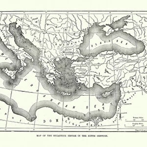
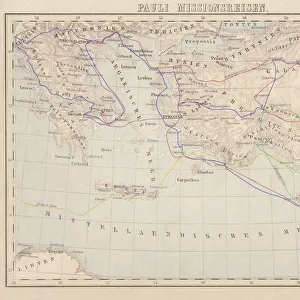
Poster Print : Map of The Byzantine Empire


Poster Prints from Mary Evans Picture Library
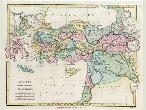
Map of The Byzantine Empire
A map showing the extent of the Byzantine Empire - the predominantly Greek-speaking continuation of the Roman Empire during Late Antiquity and the Middle Ages. Date: 1800
Mary Evans Picture Library makes available wonderful images created for people to enjoy over the centuries
Media ID 11575341
© Mary Evans / Grenville Collins Postcard Collection
1800 Anatolia Assyria Byzantine Byzantium Continuation Crete Cyprus Mediterranean Minor
18x24 inch Poster Print
Discover the rich history of the Byzantine Empire with our stunning Map of The Byzantine Empire print from Media Storehouse. This exquisite poster, sourced from Mary Evans Prints Online, takes you on a journey through Late Antiquity and the Middle Ages, showcasing the extent of the predominantly Greek-speaking continuation of the Roman Empire. With intricate detail and historical accuracy, this map print is a must-have for history enthusiasts, educators, and anyone interested in the fascinating history of the Byzantine Empire. Bring a piece of the past into your home or office with our high-quality poster print.
Poster prints are budget friendly enlarged prints in standard poster paper sizes. Printed on 150 gsm Matte Paper for a natural feel and supplied rolled in a tube. Great for framing and should last many years. To clean wipe with a microfiber, non-abrasive cloth or napkin. Our Archival Quality Photo Prints and Fine Art Paper Prints are printed on higher quality paper and the choice of which largely depends on your budget.
Poster prints are budget friendly enlarged prints in standard poster paper sizes (A0, A1, A2, A3 etc). Whilst poster paper is sometimes thinner and less durable than our other paper types, they are still ok for framing and should last many years. Our Archival Quality Photo Prints and Fine Art Paper Prints are printed on higher quality paper and the choice of which largely depends on your budget.
Estimated Product Size is 61.6cm x 46.3cm (24.3" x 18.2")
These are individually made so all sizes are approximate
Artwork printed orientated as per the preview above, with landscape (horizontal) orientation to match the source image.
FEATURES IN THESE COLLECTIONS
> Arts
> Artists
> R
> Roman Roman
> Asia
> Cyprus
> Related Images
> Asia
> Related Images
> Asia
> Turkey
> Related Images
> Europe
> Greece
> Related Images
> Historic
> Ancient civilizations
> Ancient Greece
> Greek history
> Historic
> Ancient civilizations
> Roman Empire
> Roman art
> Popular Themes
> Maps and Charts
EDITORS COMMENTS
This stunning antique map print depicts the Byzantine Empire in the year 1800, providing a captivating glimpse into the historical extent of this predominantly Greek-speaking continuation of the Roman Empire during Late Antiquity and the Middle Ages. The Byzantine Empire, also known as the Eastern Roman Empire, is shown here in all its grandeur, stretching from the Adriatic and Ionian seas in the west to the Black Sea and the Caucasus Mountains in the east, and from Anatolia in Asia Minor to the Balkans and Italy in Europe. The Mediterranean Sea dominates the map, with the Byzantine territories surrounding it, including the islands of Cyprus and Crete. Anatolia, a significant region in Asia Minor, is also clearly marked, as well as the Asian territories of Assyria and Thracia. The empire's eastern borders extend into modern-day Turkey, with Constantinople, the imperial capital, situated at the center of the map. The Byzantine Empire's rich history is evident in this map, which showcases the empire's significant cultural and political influence during Late Antiquity and the Middle Ages. The empire's legacy can still be seen today in the Greek and Turkish cultures, as well as in the many historical sites and landmarks that bear witness to its enduring impact. This map print is an essential addition to any history or geography collection, offering a unique perspective on the historical development of Europe, Asia, and the Mediterranean world. Its intricate details and accurate depiction of the Byzantine Empire's territories make it a fascinating and educational piece, transporting us back in time to an era of great historical significance.
MADE IN THE USA
Safe Shipping with 30 Day Money Back Guarantee
FREE PERSONALISATION*
We are proud to offer a range of customisation features including Personalised Captions, Color Filters and Picture Zoom Tools
SECURE PAYMENTS
We happily accept a wide range of payment options so you can pay for the things you need in the way that is most convenient for you
* Options may vary by product and licensing agreement. Zoomed Pictures can be adjusted in the Cart.