Poster Print > Europe > Spain > Related Images
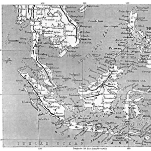
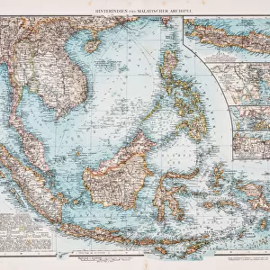
Poster Print : Map East Indies


![]()
Poster Prints from Mary Evans Picture Library
Map East Indies
Much of this region is still under Dutch rule : but todays Malaysia is part of the Birman Empire and the Philippines are claimed by Spain : Britain has yet to stake her claim... Date: circa 1827
Mary Evans Picture Library makes available wonderful images created for people to enjoy over the centuries
Media ID 14113525
© Mary Evans Picture Library
1827 Birman Claim Claimed Indies Malaysia Maps Philippines Region Rule Stake Today
18x24 inch Poster Print
"Step back in time with our exquisite Map East Indies print from the Media Storehouse collection. This captivating antique map, sourced from Mary Evans Prints Online, offers a glimpse into the historical geography of the East Indies region around 1827. Discover a world on the brink of transformation, where the Dutch, British, Spanish, and Birman Empires jostled for influence. This rights-managed print makes a stunning addition to any home or office, transporting you back to an era of exploration and discovery. Add this piece to your collection and bring a touch of history into your space."
Poster prints are budget friendly enlarged prints in standard poster paper sizes. Printed on 150 gsm Matte Paper for a natural feel and supplied rolled in a tube. Great for framing and should last many years. To clean wipe with a microfiber, non-abrasive cloth or napkin. Our Archival Quality Photo Prints and Fine Art Paper Prints are printed on higher quality paper and the choice of which largely depends on your budget.
Poster prints are budget friendly enlarged prints in standard poster paper sizes (A0, A1, A2, A3 etc). Whilst poster paper is sometimes thinner and less durable than our other paper types, they are still ok for framing and should last many years. Our Archival Quality Photo Prints and Fine Art Paper Prints are printed on higher quality paper and the choice of which largely depends on your budget.
Estimated Product Size is 61.6cm x 46.3cm (24.3" x 18.2")
These are individually made so all sizes are approximate
Artwork printed orientated as per the preview above, with landscape (horizontal) orientation to match the source image.
FEATURES IN THESE COLLECTIONS
> Asia
> Philippines
> Related Images
> Europe
> Spain
> Related Images
EDITORS COMMENTS
This map print, titled 'Map of the East Indies,' offers a glimpse into the complex political landscape of the Asian Pacific region circa 1827. At this time, much of the East Indies was still under Dutch rule, with the Netherlands maintaining colonies in present-day Indonesia and Timor. However, significant parts of the map reveal the territorial claims of other major powers, including the British and Spanish empires. Today, the regions depicted in this map have undergone dramatic transformations. For instance, the area that is now Malaysia was part of the Burmese Empire, while the Philippines were claimed by Spain. Britain, which is not yet shown as having staked a claim on any territory, would later establish colonies in Malaya, Singapore, and other parts of Southeast Asia. The intricate details on this map reflect the extensive exploratory efforts and geographical knowledge of European powers during the Age of Discovery. The map includes various islands, peninsulas, and waterways, as well as annotations indicating the locations of major ports, cities, and geographical features. The map also features elegant cartouches and decorative elements, making it a beautiful and historically significant piece. This map provides a fascinating window into the past, offering insights into the political, economic, and cultural interactions between European powers and the peoples of the East Indies during a period of intense exploration and expansion. It serves as a reminder of the rich and complex history of the Asian Pacific region and the enduring impact of European colonialism on its development.
MADE IN THE USA
Safe Shipping with 30 Day Money Back Guarantee
FREE PERSONALISATION*
We are proud to offer a range of customisation features including Personalised Captions, Color Filters and Picture Zoom Tools
SECURE PAYMENTS
We happily accept a wide range of payment options so you can pay for the things you need in the way that is most convenient for you
* Options may vary by product and licensing agreement. Zoomed Pictures can be adjusted in the Cart.