Poster Print > Arts > Artists > S > Syrian Syrian
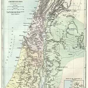
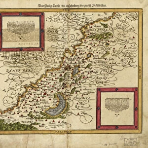
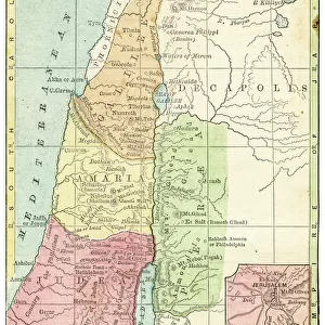
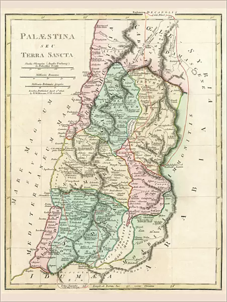
Poster Print : Map of Palestine and the Holy Land


![]()
Poster Prints from Mary Evans Picture Library
Map of Palestine and the Holy Land
Map of Palestine and the Holy Land - all places named in their Latin form. Date: 1806
Mary Evans Picture Library makes available wonderful images created for people to enjoy over the centuries
Media ID 11575327
© Mary Evans / Grenville Collins Postcard Collection
1806 Chart Damascus Dead Galilee Israel Jerusalem Maps Palestine Palestinian Ports Scale Sidon Syria Syrian Territory Tyre
18x24 inch Poster Print
Discover the rich history and cultural significance of the Holy Land with our exquisite "Map of Palestine and the Holy Land" poster print from Media Storehouse. Dating back to 1806, this antique map, sourced from Mary Evans Prints Online, showcases the region in its Latin form, providing an intriguing insight into the geography of the time. With all places named in their Latin forms, this captivating print is a must-have for history enthusiasts, educators, and anyone with an appreciation for the past. Bring the stories of the Holy Land to life in your home or office with this beautiful, vintage map from Media Storehouse.
Poster prints are budget friendly enlarged prints in standard poster paper sizes. Printed on 150 gsm Matte Paper for a natural feel and supplied rolled in a tube. Great for framing and should last many years. To clean wipe with a microfiber, non-abrasive cloth or napkin. Our Archival Quality Photo Prints and Fine Art Paper Prints are printed on higher quality paper and the choice of which largely depends on your budget.
Poster prints are budget friendly enlarged prints in standard poster paper sizes (A0, A1, A2, A3 etc). Whilst poster paper is sometimes thinner and less durable than our other paper types, they are still ok for framing and should last many years. Our Archival Quality Photo Prints and Fine Art Paper Prints are printed on higher quality paper and the choice of which largely depends on your budget.
Estimated Product Size is 46.3cm x 61.6cm (18.2" x 24.3")
These are individually made so all sizes are approximate
Artwork printed orientated as per the preview above, with portrait (vertical) orientation to match the source image.
FEATURES IN THESE COLLECTIONS
> Arts
> Artists
> S
> Syrian Syrian
> Asia
> Israel
> Related Images
> Asia
> Palestine
> Jerusalem
> Asia
> Palestine
> Related Images
> Asia
> Syria
> Related Images
EDITORS COMMENTS
This intricately detailed map, titled "Palestina et Terra Sancta" and dated 1806, offers a glimpse into the historical geography of the Middle East, focusing on the region now known as Palestine and the Holy Land. The map, which is adorned with Latin names for various places, was created during a time when European powers were increasing their influence in the region. The map provides a clear representation of the coastal cities, including Tyre, Sidon, and Jaffa, with their ports marked as important points of entry and exit. The Dead Sea, the lowest point on Earth, is also depicted, along with the Syrian border and the bustling city of Damascus. The heart of the map, however, is the region of Galilee and Judea, which includes the ancient city of Jerusalem. The map's key reveals that the scale is set at 1:1,250,000, providing a sense of the vastness of the land. The map serves as an essential historical document, illustrating the complex geography of the region during a time of significant political and cultural change. It offers a window into the past, providing valuable context for understanding the rich history of the Middle East, particularly the Holy Land, and its enduring significance in world history.
MADE IN THE USA
Safe Shipping with 30 Day Money Back Guarantee
FREE PERSONALISATION*
We are proud to offer a range of customisation features including Personalised Captions, Color Filters and Picture Zoom Tools
SECURE PAYMENTS
We happily accept a wide range of payment options so you can pay for the things you need in the way that is most convenient for you
* Options may vary by product and licensing agreement. Zoomed Pictures can be adjusted in the Cart.