Poster Print > Europe > France > Canton > Ille
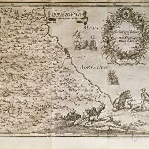
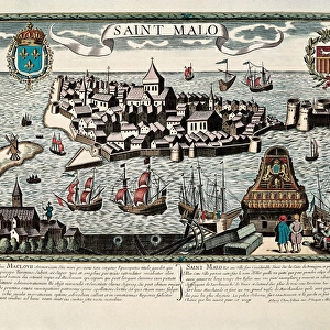
Poster Print : Map of Saint Malo, 17th c. Engraving


![]()
Poster Prints from Mary Evans Picture Library
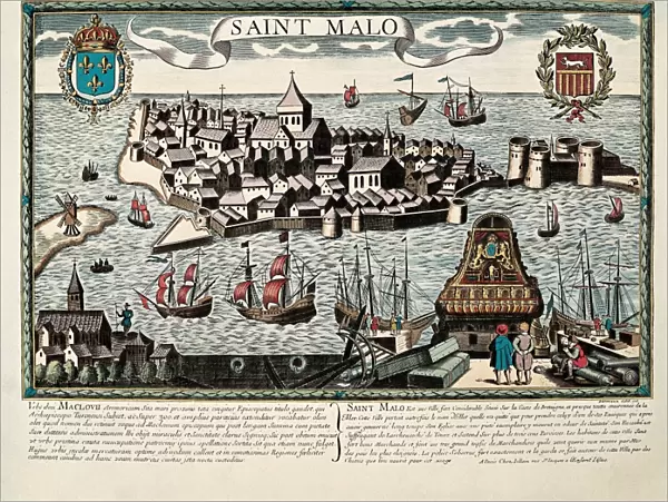
Map of Saint Malo, 17th c. Engraving
Mary Evans Picture Library makes available wonderful images created for people to enjoy over the centuries
Media ID 8283089
© Mary Evans/BeBa/Iberfoto
Bretagne Breton Bretons Britanny Day Light Engravings Fort Fortification Fortress Malo Robust Strong Sun Light Ille Vilaine
18x24 inch Poster Print
"Step back in time with our exquisite Map of Saint Malo print from the Media Storehouse collection. This stunning 17th century engraving, sourced from Mary Evans Prints Online, offers a captivating glimpse into the past. Explore the intricate details of the fortified city's layout, harbor, and surrounding lands as they appeared centuries ago. Bring historical charm to your home or office with this beautiful and authentic work of art."
Poster prints are budget friendly enlarged prints in standard poster paper sizes. Printed on 150 gsm Matte Paper for a natural feel and supplied rolled in a tube. Great for framing and should last many years. To clean wipe with a microfiber, non-abrasive cloth or napkin. Our Archival Quality Photo Prints and Fine Art Paper Prints are printed on higher quality paper and the choice of which largely depends on your budget.
Poster prints are budget friendly enlarged prints in standard poster paper sizes (A0, A1, A2, A3 etc). Whilst poster paper is sometimes thinner and less durable than our other paper types, they are still ok for framing and should last many years. Our Archival Quality Photo Prints and Fine Art Paper Prints are printed on higher quality paper and the choice of which largely depends on your budget.
Estimated Product Size is 61.6cm x 46.3cm (24.3" x 18.2")
These are individually made so all sizes are approximate
Artwork printed orientated as per the preview above, with landscape (horizontal) orientation to match the source image.
FEATURES IN THESE COLLECTIONS
> Europe
> France
> Canton
> Ille
> Historic
> Medieval architecture
> Castles and fortresses
> Ancient fortifications
> Maps and Charts
> Related Images
EDITORS COMMENTS
This stunning 17th century engraving depicts the fortified town of Saint Malo, located in the region of Brittany, France. The map, illuminated by the warm, golden rays of the sun, showcases the robust fortifications that once protected this historic port city. The exterior view highlights the strong walls and bastions, encircling the old town and the island of Saint-Malo, separated from the mainland by the Rance River. The vibrant colors of the engraving bring the map to life, revealing the intricate details of the fortresses, churches, and buildings within the city limits. The horizontal layout of the map provides an expansive view of the entire town, allowing the viewer to appreciate the strategic placement of the fortifications and the natural beauty of the surrounding landscape. The Bretons, the people of Brittany, are known for their rich history and strong cultural identity. This map serves as a testament to their resilience and the importance of Saint Malo as a significant fortified town during the 17th century. The engravings on the map are meticulously detailed, providing a glimpse into the past and offering a fascinating look at the architectural and military innovations of the time. The map of Saint Malo is a beautiful and captivating piece of historical cartography, showcasing the strong fortifications, natural beauty, and rich cultural heritage of this remarkable French town.
MADE IN THE USA
Safe Shipping with 30 Day Money Back Guarantee
FREE PERSONALISATION*
We are proud to offer a range of customisation features including Personalised Captions, Color Filters and Picture Zoom Tools
SECURE PAYMENTS
We happily accept a wide range of payment options so you can pay for the things you need in the way that is most convenient for you
* Options may vary by product and licensing agreement. Zoomed Pictures can be adjusted in the Cart.