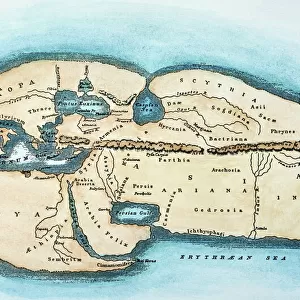
Poster Print : Maps / World / Strabo


![]()
Poster Prints from Mary Evans Picture Library
Maps / World / Strabo
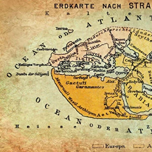
The world as known to Strabo
Mary Evans Picture Library makes available wonderful images created for people to enjoy over the centuries
Media ID 581520
© Mary Evans Picture Library 2015 - https://copyrighthub.org/s0/hub1/creation/maryevans/MaryEvansPictureID/10027529
18x24 inch Poster Print
Introducing the captivating "Maps / World / Strabo" print from our Media Storehouse collection, brought to you by Mary Evans Picture Library from Mary Evans Prints Online. This exquisite poster transport you back in time to the ancient world as it was known to the renowned geographer Strabo. Delve into the intricacies of ancient cartography and explore the world as it was depicted over 2,000 years ago. With stunning attention to detail, this print is an essential addition to any home or office space, igniting curiosity and inspiring a newfound appreciation for the rich history of cartography. Bring a touch of the ancient world into your modern life with our "Maps / World / Strabo" print.
Poster prints are budget friendly enlarged prints in standard poster paper sizes. Printed on 150 gsm Matte Paper for a natural feel and supplied rolled in a tube. Great for framing and should last many years. To clean wipe with a microfiber, non-abrasive cloth or napkin. Our Archival Quality Photo Prints and Fine Art Paper Prints are printed on higher quality paper and the choice of which largely depends on your budget.
Poster prints are budget friendly enlarged prints in standard poster paper sizes (A0, A1, A2, A3 etc). Whilst poster paper is sometimes thinner and less durable than our other paper types, they are still ok for framing and should last many years. Our Archival Quality Photo Prints and Fine Art Paper Prints are printed on higher quality paper and the choice of which largely depends on your budget.
Estimated Product Size is 61.6cm x 46.3cm (24.3" x 18.2")
These are individually made so all sizes are approximate
Artwork printed orientated as per the preview above, with landscape (horizontal) orientation to match the source image.
EDITORS COMMENTS
This print from Mary Evans Picture Library showcases a historical map titled "Maps / World / Strabo (The world as known to Strabo)." Dating back to around 30 AD, this ancient depiction offers a fascinating glimpse into the geographical knowledge of the time.
As one of the most renowned geographers and historians of antiquity, Strabo's interpretation of the world is both insightful and intriguing. The intricate details and markings on this map provide valuable insights into how people in that era perceived their surroundings.
From Europe to Asia, Africa to the Americas, this map illustrates the extent of human exploration and understanding during Strabo's lifetime. It serves as a reminder of our ancestors' curiosity about distant lands and their desire to chart unknown territories.
The craftsmanship evident in this piece is truly remarkable, showcasing not only an accurate representation of geographical features but also artistic flair. Each line drawn with precision tells a story of discovery and adventure.
For history enthusiasts or those with an appreciation for cartography, this print is sure to spark curiosity and wonder about how our world has evolved over centuries. It stands as a testament to humanity's enduring quest for knowledge and understanding of our planet.
MADE IN THE USA
Safe Shipping with 30 Day Money Back Guarantee
FREE PERSONALISATION*
We are proud to offer a range of customisation features including Personalised Captions, Color Filters and Picture Zoom Tools
SECURE PAYMENTS
We happily accept a wide range of payment options so you can pay for the things you need in the way that is most convenient for you
* Options may vary by product and licensing agreement. Zoomed Pictures can be adjusted in the Cart.