Poster Print > Popular Themes > Balaclava, Crimea
Poster Print : Crimean War


![]()
Poster Prints from Mary Evans Picture Library
Crimean War
Mary Evans Picture Library makes available wonderful images created for people to enjoy over the centuries
Media ID 7403247
© Mary Evans Picture Library 2015 - https://copyrighthub.org/s0/hub1/creation/maryevans/MaryEvansPictureID/10474856
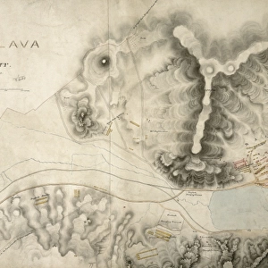
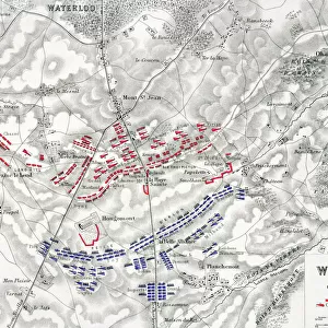
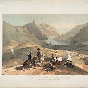
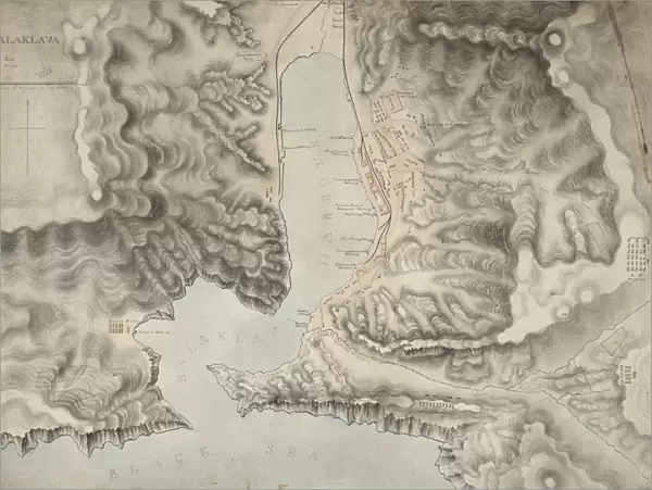
1030 Balaclava Crimea Crimean Maps Wo78
18x24 inch Poster Print
Poster prints are budget friendly enlarged prints in standard poster paper sizes. Printed on 150 gsm Matte Paper for a natural feel and supplied rolled in a tube. Great for framing and should last many years. To clean wipe with a microfiber, non-abrasive cloth or napkin. Our Archival Quality Photo Prints and Fine Art Paper Prints are printed on higher quality paper and the choice of which largely depends on your budget.
Poster prints are budget friendly enlarged prints in standard poster paper sizes (A0, A1, A2, A3 etc). Whilst poster paper is sometimes thinner and less durable than our other paper types, they are still ok for framing and should last many years. Our Archival Quality Photo Prints and Fine Art Paper Prints are printed on higher quality paper and the choice of which largely depends on your budget.
Estimated Product Size is 61.6cm x 46.3cm (24.3" x 18.2")
These are individually made so all sizes are approximate
Artwork printed orientated as per the preview above, with landscape (horizontal) orientation to match the source image.
FEATURES IN THESE COLLECTIONS
> Mary Evans Prints Online
> National Archives
> Maps and Charts
> Related Images
> Popular Themes
> Balaclava, Crimea
EDITORS COMMENTS
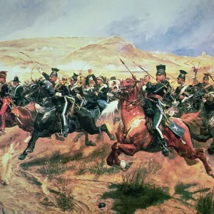
This map print depicts the key locations and events of the Crimean War (1853-1856), a significant conflict in European history that took place during the 19th century. The map, titled "Map of the Crimea and the Black Sea," meticulously illustrates the strategic regions involved in the war, including the Crimean Peninsula, the Black Sea, and the Danube River. The Crimean War was a complex conflict that arose from a number of factors, including the great power rivalries of the time, the desire for territorial expansion, and religious tensions. The major powers of Europe, including Russia, Great Britain, France, and the Ottoman Empire, all played a role in the conflict. One of the most famous battles of the Crimean War took place at Balaklava, which is marked on the map. This battle, also known as the Battle of the Balaklava Road or the Battle of Balaclava, took place on October 25, 1854. It is most famous for the Charge of the Light Brigade, a disastrous cavalry charge that resulted in heavy losses for the British and French forces. The map also highlights other key locations and battles of the war, such as Sevastopol, Alma, and Inkerman. The map's intricate details and clear labeling make it an invaluable resource for anyone interested in the history of the Crimean War and the geopolitical landscape of Europe during the 19th century. This map print is a fascinating glimpse into the past, offering a unique perspective on a pivotal moment in history. Its antique aesthetic and meticulous attention to detail make it a beautiful addition to any home or office, and a conversation starter for history enthusiasts and casual observers alike.
MADE IN THE USA
Safe Shipping with 30 Day Money Back Guarantee
FREE PERSONALISATION*
We are proud to offer a range of customisation features including Personalised Captions, Color Filters and Picture Zoom Tools
SECURE PAYMENTS
We happily accept a wide range of payment options so you can pay for the things you need in the way that is most convenient for you
* Options may vary by product and licensing agreement. Zoomed Pictures can be adjusted in the Cart.