Poster Print > Europe > France > Canton > Allier
Poster Print : Map of Europe showing WW2 alliances, September 1939


![]()
Poster Prints from Mary Evans Picture Library
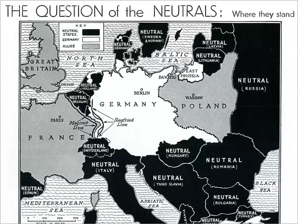
Map of Europe showing WW2 alliances, September 1939
A map of Europe, colour-coded to represent the different alliances between nations shortly after the outbreak of war, September 1939. The accompanying article lists the various sympathies of the neutral European powers and the title; " the question of the neutrals", highlights how important their support will be in the coming war.
1939
Mary Evans Picture Library makes available wonderful images created for people to enjoy over the centuries
Media ID 23268940
© Illustrated London News Ltd/Mary Evans
Alliance Allied Allies Countries Jul19 Maps Neutral Outbreak Power Powers Alliances Neutrals
18x24 inch Poster Print
Step back in time with our captivating Map of Europe showing WW2 Alliances, September 1939, from the Illustrated London News Ltd/Mary Evans collection. This vintage poster print offers a unique and educational perspective on the complex political landscape of Europe on the brink of war. The colorful representation of alliances between nations adds depth and intrigue to this historical piece. Bring a piece of the past into your home or office with this striking and informative poster print.
Poster prints are budget friendly enlarged prints in standard poster paper sizes. Printed on 150 gsm Matte Paper for a natural feel and supplied rolled in a tube. Great for framing and should last many years. To clean wipe with a microfiber, non-abrasive cloth or napkin. Our Archival Quality Photo Prints and Fine Art Paper Prints are printed on higher quality paper and the choice of which largely depends on your budget.
Poster prints are budget friendly enlarged prints in standard poster paper sizes (A0, A1, A2, A3 etc). Whilst poster paper is sometimes thinner and less durable than our other paper types, they are still ok for framing and should last many years. Our Archival Quality Photo Prints and Fine Art Paper Prints are printed on higher quality paper and the choice of which largely depends on your budget.
Estimated Product Size is 61.6cm x 46.3cm (24.3" x 18.2")
These are individually made so all sizes are approximate
Artwork printed orientated as per the preview above, with landscape (horizontal) orientation to match the source image.
FEATURES IN THESE COLLECTIONS
> Mary Evans Prints Online
> New Images August 2021
> Europe
> France
> Canton
> Allier
> Europe
> Related Images
> Historic
> World War I and II
> World War II
> Maps and Charts
> Related Images
> Maps and Charts
> World
EDITORS COMMENTS
September 1939: The Question of the Neutrals - A Map of Europe and the Alliances at the Outbreak of World War II As the ominous shadows of war loomed over Europe in September 1939, the continent was a complex tapestry of alliances and neutral powers. This evocative map, published by the Illustrated London News in the early days of the conflict, offers a colour-coded representation of the various European nations and their allegiances. The Axis Powers, led by Germany, are depicted in a menacing dark red. The Allied Powers, primarily France and the United Kingdom, are shown in a bold, resolute blue. The map also highlights the neutral European countries, painted in various shades of grey, whose sympathies and eventual involvement would prove pivotal in the coming conflict. Switzerland, Belgium, Holland, and Sweden, among others, were determined to maintain their neutrality, despite the mounting pressure from both sides. Their support, or lack thereof, would significantly impact the outcome of the war. The map serves as a poignant reminder of the intricate web of political alliances and the delicate balance of power that defined Europe on the brink of World War II. The title, "The Question of the Neutrals," underscores the importance of these countries in the unfolding conflict. As the world watched with bated breath, the fate of Europe hung in the balance, and the choices made by these neutral powers would shape the course of history. This historic map, originally published by the Illustrated London News Ltd. in September 1939, offers a captivating glimpse into the complex geopolitical landscape of Europe on the eve of World War II.
MADE IN THE USA
Safe Shipping with 30 Day Money Back Guarantee
FREE PERSONALISATION*
We are proud to offer a range of customisation features including Personalised Captions, Color Filters and Picture Zoom Tools
SECURE PAYMENTS
We happily accept a wide range of payment options so you can pay for the things you need in the way that is most convenient for you
* Options may vary by product and licensing agreement. Zoomed Pictures can be adjusted in the Cart.