Poster Print > Animals > Mammals > Cricetidae > California Mouse
Poster Print : HSET2A-00123

![]()
Poster Prints from North Wind
HSET2A-00123
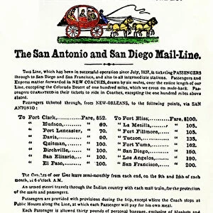
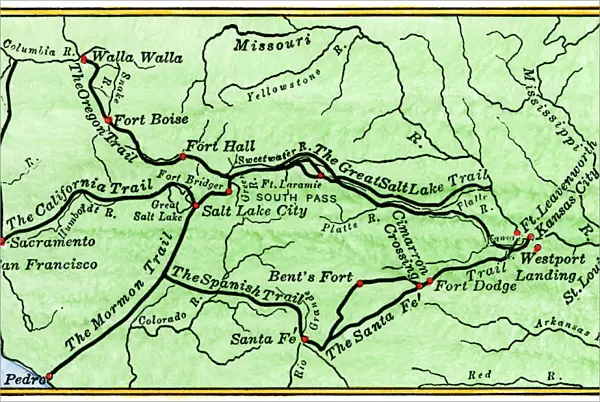
Map of the principal westward trails in the 1800s.
Hand-colored woodcut of a 19th-century illustration
North Wind Picture Archives brings history to life with stock images and hand-colored illustrations
Media ID 5877245
© North Wind Picture Archives
California Trail Diagram Fort Fort Laramie Frontier Mormon Trail Oregon Trail Pioneer Santa Fe Trail Settler Trail West Western Boise Salt Lake
20x30 inch Poster Print
Step back in time with our captivating HSET2A-00123 poster print from the Media Storehouse collection, featuring a beautifully hand-colored woodcut illustration of the principal westward trails in the 1800s from North Wind Picture Archives. This vintage map transports you to an era of adventure and discovery, perfect for adding historical charm to your home or office. With intricate detail and rich colors, this poster print is a stunning addition to any room, igniting the imagination and sparking conversation. Bring a piece of the past into your present with this exquisite and authentic work of art.
Poster prints are budget friendly enlarged prints in standard poster paper sizes. Printed on 150 gsm Matte Paper for a natural feel and supplied rolled in a tube. Great for framing and should last many years. To clean wipe with a microfiber, non-abrasive cloth or napkin. Our Archival Quality Photo Prints and Fine Art Paper Prints are printed on higher quality paper and the choice of which largely depends on your budget.
Poster prints are budget friendly enlarged prints in standard poster paper sizes (A0, A1, A2, A3 etc). Whilst poster paper is sometimes thinner and less durable than our other paper types, they are still ok for framing and should last many years. Our Archival Quality Photo Prints and Fine Art Paper Prints are printed on higher quality paper and the choice of which largely depends on your budget.
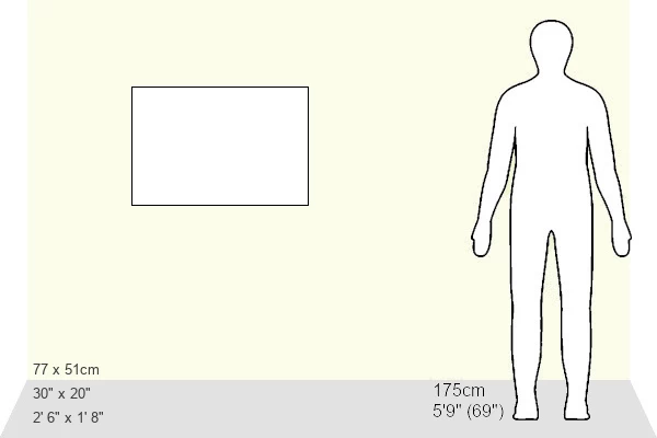
Estimated Product Size is 76.8cm x 51.4cm (30.2" x 20.2")
These are individually made so all sizes are approximate
Artwork printed orientated as per the preview above, with landscape (horizontal) or portrait (vertical) orientation to match the source image.
FEATURES IN THESE COLLECTIONS
> North Wind Picture Archives
> American West
> North Wind Picture Archives
> Maps
> Animals
> Mammals
> Cricetidae
> California Mouse
> Animals
> Mammals
> Muridae
> Western Mouse
> Europe
> Spain
> Related Images
> Maps and Charts
> Spain
> North America
> Related Images
> South America
> Related Images
EDITORS COMMENTS
This photo print, titled "HSET2A-00123: Map of the principal westward trails in the 1800s" takes us on a visual journey back to the American frontier of the 19th century. Hand-colored with meticulous detail, this woodcut illustration beautifully captures the essence of a bygone era. The map showcases an intricate network of pioneer trails that were crucial for westward expansion during this transformative period in history. From its vintage charm to its traditional artistic style, this print serves as a window into North America's past and invites us to explore its rich heritage. Highlighted on the map are iconic routes such as the Oregon Trail, Santa Fe Trail, California Trail, and Mormon Trail. Each trail represents countless stories of settlers seeking new opportunities and adventures across untamed lands. Forts like Dodge, Laramie, Bridger, Boise, and Bent's Fort dotting these paths remind us of their strategic importance in providing shelter and protection along arduous journeys. As we gaze upon this remarkable piece of artistry from North Wind Picture Archives, we can almost hear wagon wheels creaking under heavy loads and imagine pioneers forging ahead through rugged terrains towards their dreams. It is a testament to human resilience and determination that shaped our nation's history. With every glance at this historic treasure trove encapsulated within one frame—salt lakes shimmering in Utah or South Pass leading intrepid souls through Wyoming—we are reminded how far we have come while honoring those who paved
MADE IN THE USA
Safe Shipping with 30 Day Money Back Guarantee
FREE PERSONALISATION*
We are proud to offer a range of customisation features including Personalised Captions, Color Filters and Picture Zoom Tools
SECURE PAYMENTS
We happily accept a wide range of payment options so you can pay for the things you need in the way that is most convenient for you
* Options may vary by product and licensing agreement. Zoomed Pictures can be adjusted in the Cart.