Poster Print > Europe > United Kingdom > Scotland > Maps
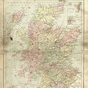
Poster Print : Scotland map, 1870s


Poster Prints from North Wind
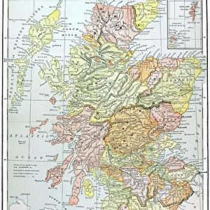
Scotland map, 1870s
Map of Scotland, 1870s.
Printed color lithograph
North Wind Picture Archives brings history to life with stock images and hand-colored illustrations
Media ID 5879180
© North Wind Picture Archives
1870s British British Isles Europe European Great Britain Scot Land Scottish Territory
18x24 inch Poster Print
Discover the rich history of Scotland with our stunning, vintage-inspired poster prints from Media Storehouse. This captivating map of Scotland, dating back to the 1870s, is a beautiful addition to any home or office. Printed using high-quality, color lithography techniques from the North Wind Picture Archives, each print brings the past to life with intricate detail and vibrant colors. Transport yourself back in time as you explore the historical landscapes and geographical features of Scotland. Add this unique and charming piece to your collection today and make a statement with a touch of history.
Poster prints are budget friendly enlarged prints in standard poster paper sizes. Printed on 150 gsm Matte Paper for a natural feel and supplied rolled in a tube. Great for framing and should last many years. To clean wipe with a microfiber, non-abrasive cloth or napkin. Our Archival Quality Photo Prints and Fine Art Paper Prints are printed on higher quality paper and the choice of which largely depends on your budget.
Poster prints are budget friendly enlarged prints in standard poster paper sizes (A0, A1, A2, A3 etc). Whilst poster paper is sometimes thinner and less durable than our other paper types, they are still ok for framing and should last many years. Our Archival Quality Photo Prints and Fine Art Paper Prints are printed on higher quality paper and the choice of which largely depends on your budget.
Estimated Product Size is 46.3cm x 61.6cm (18.2" x 24.3")
These are individually made so all sizes are approximate
Artwork printed orientated as per the preview above, with portrait (vertical) orientation to match the source image.
FEATURES IN THESE COLLECTIONS
> North Wind Picture Archives
> British history
> North Wind Picture Archives
> Maps
> Europe
> France
> Canton
> Landes
> Europe
> United Kingdom
> Maps
> Europe
> United Kingdom
> Scotland
> Maps
> Europe
> United Kingdom
> Scotland
> Posters
> Europe
> United Kingdom
> Scotland
> Related Images
> Maps and Charts
> Related Images
> Popular Themes
> Maps and Charts
EDITORS COMMENTS
This stunning vintage print showcases a meticulously detailed map of Scotland, dating back to the 1870s. The rich hues of printed color lithography bring this piece to life, capturing the essence of Scottish heritage and tradition. The map itself is a testament to the historic significance of Scotland within Great Britain and Europe as a whole. Every contour, river, and town is intricately illustrated, providing an invaluable glimpse into the territory's past. This artwork serves as a visual time capsule from the 19th century, offering viewers a chance to explore British history through cartography. As we gaze upon this print, we are transported back in time to an era when maps were not just navigational tools but works of art themselves. The attention to detail and artistic flair evident in this piece truly make it stand out. Whether you have personal ties to Scotland or simply appreciate historical artifacts, this print is sure to captivate your imagination. It serves as a reminder that even in our modern world dominated by GPS systems and digital mapping technologies, there is still something enchanting about holding a physical representation of our past. Displaying this magnificent map on your wall will not only add character and charm but also spark conversations about history and geography for years to come.
MADE IN THE USA
Safe Shipping with 30 Day Money Back Guarantee
FREE PERSONALISATION*
We are proud to offer a range of customisation features including Personalised Captions, Color Filters and Picture Zoom Tools
SECURE PAYMENTS
We happily accept a wide range of payment options so you can pay for the things you need in the way that is most convenient for you
* Options may vary by product and licensing agreement. Zoomed Pictures can be adjusted in the Cart.